During emergency response, knowing where our responders are located increases their safety. It enables decision-makers and incident management teams to make informed decisions, increases resource allocation efficiency, and ensures personnel can receive help if needed. In our previous blog post, “Lost and Found: How ArcGIS and GPS Change Location Sharing in the Wild,” we explored how disconnected environments challenge first responders and how we can track them despite their lack of connectivity. In this blog post, we’ll look at how we can achieve location sharing in connected environments with the apps that many agencies already use.
As a quick reminder, to say that we’ve truly solved the location sharing issue for responders, we must obtain location sharing across the following three environments:
Disconnected – Responder to Incident Command Post (Disconnected to Connected): While we want the responders in the field to know each other’s locations, we also want to ensure their locations are visible to incident management teams or managers in connected environments. This means that we need something more than a mesh network, because we need to retrieve the location data out of the field and make it accessible for decision-makers in a connected environment at places like an incident command post. Note: Mesh is still required for offline responder-to-responder location sharing.
Connected: In this environment, we assume that our responders are operating within cell or Wi-Fi connectivity, which we can leverage to populate location data. This is by far the easiest of scenarios to achieve location sharing and can be accomplished with the appropriate user type and any of the field apps you already own.
Disconnected – Responder to Responder (Disconnected to Disconnected): In disconnected environments (no cell or Wi-Fi service), responders need to locate one another. To achieve this, we need technology that creates a local area network (LAN) of sorts—a mesh network. This ensures that location data can be exchanged between the devices in the field. As a result, responders can visualize one another on a common map in the disconnected environment.
Mobile Apps in Connected Environments
In areas with internet or cellular connectivity, mobile applications like ArcGIS Field Maps, ArcGIS Survey123, and ArcGIS QuickCapture allow responders to share their locations in near real time. These apps natively integrate with ArcGIS Online, allowing live positions of responders to be visualized on maps accessible to both field teams and command centers.
How It Works:
User Activation: Responders enable location sharing within their app, which begins transmitting their location.
Data Transmission: The app sends location data to ArcGIS Online or ArcGIS Enterprise as a layer, updating positions in near real time.
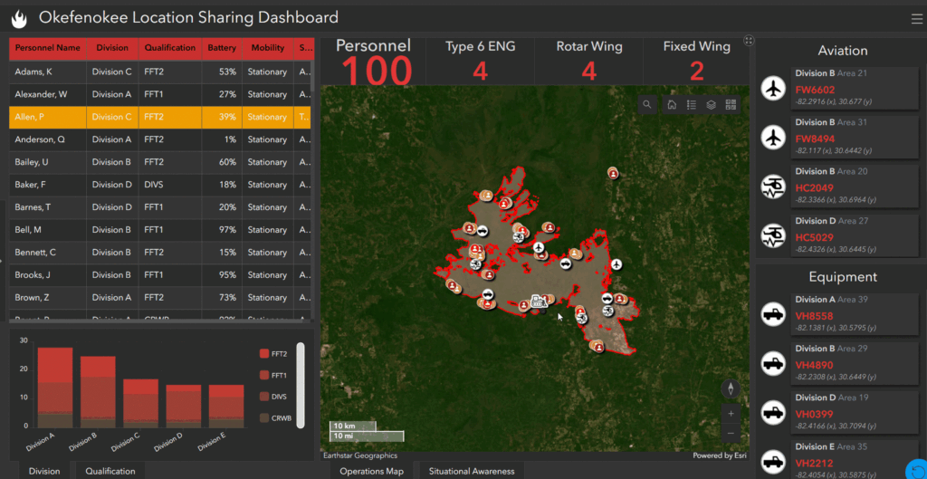
Visualization: Commanders and team members view locations on dashboards or mobile devices updated at user-defined intervals. The app sends location data to ArcGIS Online or ArcGIS Enterprise as a layer, updating positions in near real time.
Implementing Location Sharing
Deploying these capabilities is straightforward:
Licensing: Organizations assign Mobile Worker user type licenses or extensions to enable location sharing features within the apps.
Configuration: Administrators enable location sharing in organizational settings and set up track views to control data visibility among users.
Track views are particularly beneficial, allowing administrators to segment location data by roles or teams, ensuring that sensitive information is shared appropriately.
Enhancing Location Sharing with Advanced Features
In our last blog post, we highlighted the capabilities that ArcGIS Velocity brings when enriching location data in disconnected environments. However, just because we’re operating in a connected environment doesn’t mean that Velocity has a diminished role—if Velocity is utilized, all that enrichment can still occur:
Geofencing: Establish virtual boundaries to monitor entries and exits, triggering alerts for unauthorized movements, or even enable and disable location sharing when entering or departing an incident area.
Qualification Filtering: Sort responders by qualification levels to deploy appropriate personnel for specific tasks.
For those looking to implement geofencing in Field Maps without Velocity, refer to this documentation about geofences in ArcGIS Field Maps.
Preparing for the Future
As technologies like satellite-based connectivity and drone-enabled mobile networks become more accessible, the reach of connected environments will expand. Agencies must proactively develop plans to integrate these advancements, ensuring responders are equipped with the latest tools for safety and efficiency. Embracing mobile applications for real-time location tracking in connected environments is another step toward enhancing the safety and effectiveness of responders. By understanding and implementing these technologies, agencies can ensure that their field personnel are always accounted for.
Learn more
To learn more about GIS solutions for wildland fire, visit our solutions page or download our ebook.