On his first day in office President Biden signed an executive order to further advance equity within underserved communities by incorporating requirements into federal agencies. The Executive Order orders all agencies to create equity action plans.
“The President’s Order emphasized the enormous human costs of systemic racism, persistent poverty, and other disparities, and directed the Federal Government to advance an ambitious, whole-of-government equity agenda that matches the scale of the challenges we face as a country and the opportunities we have to build a more perfect union.” Advancing Equity and Racial Justice Through the Federal Government | The White House
This is in continuum with his Diversity, Equity, Inclusion, and Accessibility in the Federal Workforce order that was passed to ensure his administration is the most diverse, to reflect the growing diversity within American communities.
In this executive order President Biden hopes to launch a whole-of-government approach to equity. I make note of this as this is Esri’s approach to equity as well. Enhancing equity has traditionally been viewed as work that community-based organizations, civic nonprofits, grassroots organizations, and activists have engaged in. The Executive Order now aims to integrate equity nationwide placing the ownership on everyone. What many do not understand is that these issues are embedded into everyone’s work. From where the department of transportation builds a highway to where a new park is constructed should all start off with an equity lens. A successful equity lens adopts the geographic approach. The geographic approach is a way of thinking and a way of problem solving, it allows leaders to address a problem by first looking at which communities are impacted the most. By leveraging geographic information system (GIS) technology organizations can quickly deploy targeted solutions maximizing their impact.
In this blog I outline three keyways that GIS tools can be used to enhance the Biden Administrations’ commitment to remove the barriers underserved communities continue to face.
1. Strengthen community engagement and transparency
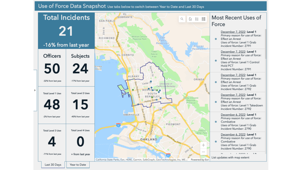
Part of the problem is that community members face barriers in engaging with federal agencies. These barriers range from meetings conflicting with work hours, language barriers, websites that are difficult to navigate and are not user friendly, and data that is not always publicly available. Agencies have an opportunity to utilize GIS tools to increase engagement by making data more user friendly and accessible to the public. GIS tools such as ArcGIS dashboards and hub sites allow governments to easily display data in real-time, allowing community members to access policy updates via smart phones or laptops.
2. Invest in underserved communities
Governments are in possession of thousands of dollars via the Bipartisan Infrastructure Law, Inflation Reduction Act, and other federal funding grants. This poses a huge opportunity for them to invest back into communities or maybe fund programs and projects they were unable to beforehand. However, to ensure equitable investments organizations must leverage GIS tools to visualize which communities have been disproportionately impacted and underinvested in compared next to which communities have continuously received funding.
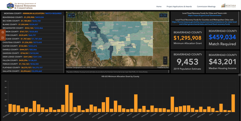
Hub sites and dashboards such as the Montana one above allows governments to easily visualize which communities are being neglected and where they should invest next.
3. Promote data equity and transparency
The executive order calls for governments to facilitate better collection, analysis, and use of demographic data to advance equity, and to regularly report on progress to the White House and the American public. GIS tools such as ArcGIS Survey123 are regularly used to collect data and easily streamline that data into internal systems or to public facing systems such as dashboards and hub sites. Governments can also leverage public demogrphic data via ArcGIS Living Atlas of the World which verifies and publishes data from a variety of government agencies.
Leveraging GIS Technology to Enhance Equity
It is a huge milestone for the current administration to acknowledge historic systemic inequities and not only acknowledge this but also set requirements that local governments must follow to remove these barriers and ensure an equitable world for all Americans. Without technology and a strategic plan these orders can fall short, and therefore I believe adopting a geographic approach provides organizations with the necessary perspective to address these issues.
Learn how you can develop an equity strategic plan with GIS tools.