I am fortunate to live in an area that experiences four distinct seasons throughout the year, and those who know me don’t have to guess which is my least favorite. That’s right – although I appreciate nature’s beauty in winter, I don’t appreciate the frozen misery that comes with it! Too many hours spent out working in it as a ranch kid, and later as a surveyor, I guess. What I do love about winter, however, is that it is also surveying convention season throughout much of the country. And this year, I had the privilege of attending and speaking at a number of them. While there were many common threads, one question I was asked repeatedly was, “What are some ways I can leverage GIS in my surveying firm?” So, I decided it was time to summarize my top five responses and share them with everyone:
1.) Firm Management – Surveying is a Spatial Business
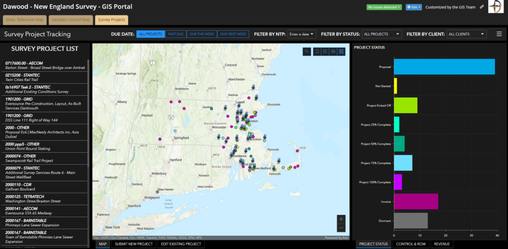
One recurring theme was how much your workload continues to increase and how difficult it is to keep track of where you have worked and what was done. Imagine if you could open a map on a web browser at any time, from anywhere, and know? With GIS, you can put your project areas together on one map (a great reason to work in a projected coordinate system if you are not already). Add a few basic attributes such as year, client, and project number, along with a link to the final deliverable, and you are well on your way to being so organized that you won’t know how you lived without it! Feeling bold? Add a few more attributes like client type, project type, and contract amount. Now, you can start to analyze patterns in your business. Create a simple ArcGIS dashboard to track patterns in project types, clients, and contract amounts year-to-year.
Have a new employee starting? Providing access to a comprehensive map of the projects completed by the firm and easy access to archived deliverables goes a long way during training! It also increases efficiency for project managers when scoping out new projects. Awareness of previous work in an area can help the project manager identify if there were challenges, constraints, or other extenuating circumstances encountered. It also reduces the amount of time spent researching and minimizes duplication of effort from project to project.
2.) Project Management – There is a Lot to Keep Track of
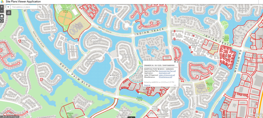
Regardless of the type of projects you work on, you probably gather a lot of background information as you prepare to work on the project. Maps, plats, plans, reports, service cards, and so on. And it probably comes in a lot formats – including paper. Are you tired of the “traveling box” full of documents that moves around the office to each person who needs to use it? And what about those dreadful document hoarders? You know what I’m talking about. Those individuals who can’t let go and put ALL of the documents back in the box to move on but instead store some of them in their field trucks for safekeeping…
All jokes aside, there is a better way. You invest a lot of time and money in research, which is the foundation of your decisions throughout a project. By leveraging GIS, you can create a quick map and spatially index all of the information you’ve retrieved. Publish it out to a web map, and now your team members ALL have instant access– to ALL project data anytime, from anywhere.
Some of you expressed concern over the time required to scan or digitize paper records so they can be included in the map. From my experience, the amount of time spent converting to digital is far less than the time lost due to not having complete information readily accessible. The good news is many organizations either have or are in the process of converting records to a digital format.
3.) Collaboration – Communication is Key
Public-private partnerships are key for many surveyors’ businesses and the success of public infrastructure projects. GIS strengthens these collaborations by providing a way to seamlessly share project updates and gather feedback in real-time through interactive web maps, dashboards, and surveys. Final deliverables can be digitally submitted and as-built conditions captured using ArcGIS Field Maps and high-accuracy data collection methods – straight into the owner’s GIS!
Need to mail project notification letters and questionnaires to impacted landowners? With GIS, you can easily automate the generation of letters for mailing. And, by creating an ArcGIS Survey123 form to capture questionnaire feedback, there is a reduction in postage and supplies for return mailing. It also eliminates the need for manual entry of responses for tabulation and analysis; it all happens in real-time, allowing you and your client to visualize the data as it comes in.
Public meetings are also commonly required for these community projects. With GIS, it is easy to facilitate meetings, gather feedback, and provide ongoing project updates through web maps or ArcGIS Story Maps. The ability to provide current information to residents and other stakeholders, such as EMS, when conditions are continuously changing (e.g. during construction), improves confidence in public agencies and results in a better experience for all.
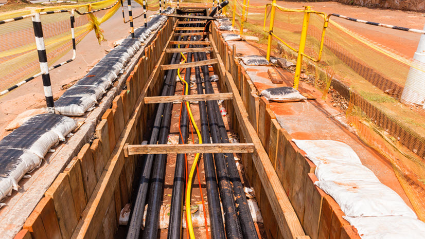
4.) Field Safety and Efficiency – Being Productive and Bringing Everyone Home Safely
Safety is paramount for all surveyors working in the field. Many companies have their own requirements for ensuring safety protocols are being followed, as do many project owners. GIS can help streamline the process:
- Document your daily toolbox/tailgate talks. ArcGIS Survey123 is a great way to gather crew member acknowledgment signatures and share them with clients, if necessary.
- Enable geofences to ensure crews do not enter areas that are unsafe or they do not have permission to be in.
Right behind safety in the field is efficiency. We have all experienced getting out in the field (sometimes a LONG way out) and not having a key piece of information. Ok – quiz time: what did we cover in item two above? That is right – project management! Having all that project information in your pocket, accessible on your mobile device, can really come in handy. Especially when you are a few hours/hundred miles down the road! Work in some remote areas that don’t have cell coverage? Not to worry – ArcGIS Field Maps can easily go offline and keep you working.
Now that we have covered the beginning of your day and saved you an unnecessary trip back to the office, what about the other end of the day? Ever stay out a couple of extra hours just to make sure you had it all so you wouldn’t have to come back—only to find out once you are back in the office that a small (but critical) area is missing? I know—sigh. You thought the other crew picked it up, didn’t you? By collecting data in real-time and having it available to the whole team, other crews can see what has been accomplished, and so can managers in the office. This is very helpful for planning future work and monitoring project progress.
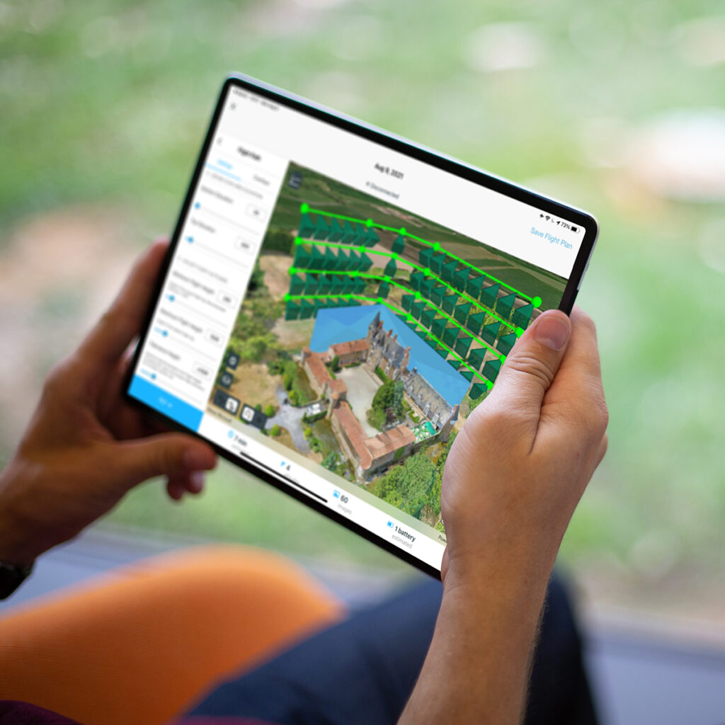
5.) Drone Operations – A One-Stop Shop with GIS
Have you taken the leap and added drones to your surveying business? They are a great way to enhance your work, aren’t they? If you haven’t had a chance to check out ArcGIS Reality, you really should. It is another example of how GIS can augment the work you are already doing. Providing a seamless end-to-end solution, Esri software can manage your drone fleet, facilitate flight planning, process captured data, and produce 2D and 3D mapping deliverables for sharing and analysis. Don’t forget to include ArcGIS Field Maps and its high-accuracy data capture ability for your ground control needs.
These are just a few of the ways GIS can help surveyors in their daily business. There are many more. Stay tuned for “Part Two” and we will explore more together.