The Esri International Infrastructure Management & GIS (IMGIS) Conference is a key event for professionals in infrastructure management and Geographic Information Systems (GIS). It provides a platform for professionals from various sectors including architecture, engineering, construction (AEC); electric, gas, and district energy; telecommunications; transportation; and water to share insights and explore innovative solutions for optimizing infrastructure planning, development, and sustainability.
Let’s explore how each key insight shapes the future of GIS and infrastructure:
Energy Transition and Renewables
Germany’s move towards transitioning from traditional to renewable energy sources stands as a model for change. GIS plays an important role in this transition, providing tools to analyze renewable energy potential, strategize infrastructure planning, and optimize resource allocation. As nations globally pivot towards cleaner energy, GIS assumes a central role in guiding these transitions by providing precise data and modeling scenarios for policymakers and planners.
Juergen Schomakers, CEO of Esri Deutschland, highlights Germany’s steadfast commitment to renewable energy. Schomakers articulates an ambitious goal for Germany: by 2030, 80% of the nation’s energy should stem from renewable sources. This commitment forms part of a broader strategy to reshape Germany’s energy landscape.
Integral to this strategy is the phased decommissioning of nuclear power plants. Germany has already retired 17 nuclear reactors, marking a significant shift in its energy policy. Concurrently, efforts are underway to phase out lignite and hard coal, traditional yet environmentally harmful energy sources.
In support of its energy transition, Germany is investing heavily in renewable energy sources such as offshore wind parks, solar installations, and wind farm management. These initiatives are crucial components of the country’s renewable energy infrastructure, providing a substantial and sustainable power source to meet future energy demands. This multifaceted approach demonstrates Germany’s commitment to a cleaner and more sustainable energy future. GIS is being utilized to visualize and analyze the generation, transportation, and distribution of energy in these new developments.
Climate Resiliency
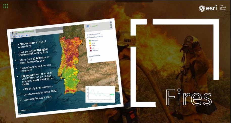
In Portugal, the increasing frequency of heat waves has tragically resulted in the loss of thousands of lives. To combat this, cities and municipalities are undertaking efforts to redesign and construct green infrastructure. With 60% of the territory facing severe fire risks exacerbated by prolonged droughts, GIS emerges as a crucial tool for preparedness.
GIS’s real-time application proves particularly valuable in disaster response. Through its integration with satellite data and weather forecasts, authorities can swiftly detect and track wildfires, optimize resource allocation, and plan evacuation routes, ultimately saving lives and mitigating property damage. As climate change impacts 20% of the population, new infrastructure projects, such as water collection from the sea, aim to address these challenges and ensure sustainability for future generations.
The City of Lisbon utilizes GIS and BIM integration to combat persistent urban challenges like flooding, fostering improved urban design and disaster resilience. The Lisbon Drainage Master Plan, a response to the city’s historical flooding issue, is leveraging GIS to forecast a significant reduction in flood incidents, aiming to mitigate over 70% of occurrences. Through initiatives such as constructing tunnels, anti-pollution basins, and reservoirs, Lisbon is not only addressing flood prevention but also promoting water reuse and pollution management, contributing to urban sustainability. Floods not only pose a threat to the safety of residents but also impact critical sectors like tourism and trade, emphasizing the importance of effective flood mitigation strategies for the city’s economic stability and growth.
The Master Plan’s effectiveness is amplified by GIS integration, facilitating the precise mapping of infrastructure and environmental factors crucial for efficient project planning and execution. This integrated approach ensures optimized resource allocation and accuracy throughout the implementation process, contributing to Lisbon’s endeavors in building sustainable and resilient urban landscapes amidst growing urbanization and climate change pressures. By harnessing the power of GIS and BIM integration, Lisbon demonstrates its commitment to addressing complex urban challenges and creating a safer, more prosperous environment.
Planning and Development
The expansion of the power grid to accommodate growing energy demands requires meticulous planning and optimization. GIS offers tools for cost analysis, route optimization, and 3D visualization, enabling efficient grid expansion while minimizing environmental impact. As renewable energy adoption increases and grids become more complex, GIS plays a pivotal role in ensuring the reliability and sustainability of energy infrastructures by providing essential spatial data analysis and visualization.
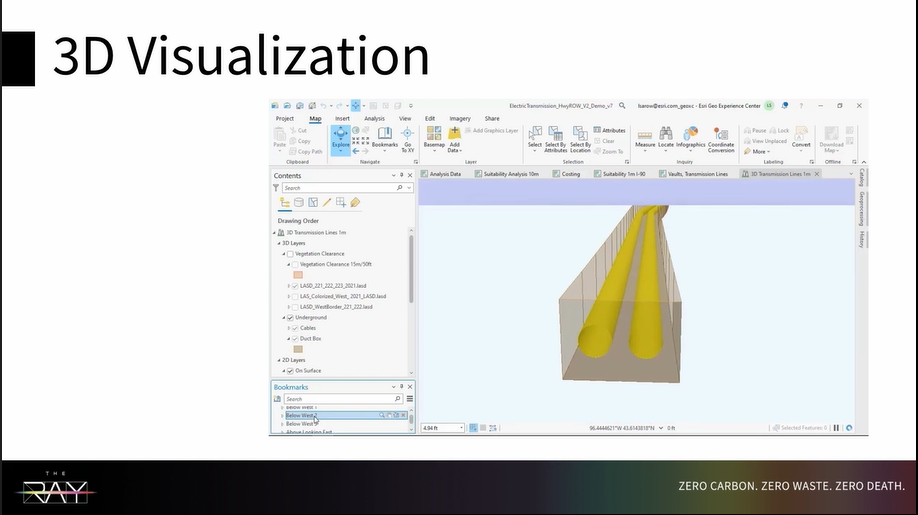
The Ray, a non-profit organization collaborating with public agencies to innovate infrastructure, has joined forces with Minnesota’s Department of Transportation. Their aim is to visualize critical data both above and below ground. Leveraging Minnesota’s data on their own right-of-way, they are pioneering the development of the first GIS tool for evaluating highway roadsides for buried high-voltage direct current (HVDC) in Minneapolis, Minnesota.
This initiative involves conducting suitability analyses and determining optimal paths for right-of-way considerations concerning underground maintenance faults. Through 3D visualization of HVDC, they can pinpoint the most efficient locations for mapping underground vaults to facilitate infrastructure development. Recognizing the pivotal role of GIS in their planning process, they emphasize situational awareness as crucial, instilling confidence for The Ray to proceed with the project.
Real-Time Operations
Efficient management of utility networks and assets is essential for ensuring reliable service delivery. GIS provides real-time insights into network performance, asset conditions, and maintenance needs. By integrating GIS with IoT sensors and predictive analytics, utilities can optimize operations, reduce downtime, and improve customer service. GIS enables smarter, more interconnected infrastructure networks that adapt to changing demands in real-time.

Rotterdam District Heating and Cooling is taking significant strides in enhancing its infrastructure by integrating the ArcGIS Utility Network and ArcGIS Experience Builder. This advanced integration allows the organization to filter data by floors, greatly improving the efficiency of facility management. In addition, they are utilizing 2D indoor mapping and 3D vertical asset mapping capabilities, which enable seamless inspection and monitoring of changes across different floors.
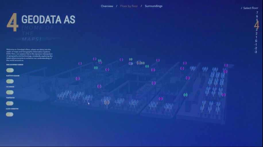
Geodata AS is revolutionizing its operations through the use of ArcGIS combined with real-time analytics. By integrating Building Information Modeling (BIM) models, they can precisely draw polygons, ensuring accurate asset placement and management. Additionally, the deployment of real-time sensors allows for dynamic visualization of assets, providing critical, real-time insights into their infrastructure. These technological advancements highlight a significant shift towards more advanced and integrated approaches in the management and monitoring of utility networks.

EDF Energy is leveraging GIS technology in constructing a nuclear power station, using maps as a universal language to enhance communication and coordination. Jon Dolphin, IT Program Manager, highlights the significance of the site context map in aiding situational awareness, while the area coordination tool streamlines project management. Drones capture aerial data, color-coded to highlight key areas and contractor priorities. Specialized apps and dashboards support field operations, tracking various project aspects, including the accessibility of fire assembly points, prioritizing safety in decision-making. Dolphin, emphasizes the critical role of GIS in providing essential support for the project’s success and safety.
Geospatial digital twins, a virtual representation of reality, encompassing physical objects, processes, and relationships, built on a foundation of geographic information, revolutionize asset management and facility operations. GIS plays a central role in creating and integrating digital twins, providing spatial context and real-time data visualization. As industries increasingly adopt digital twins for asset management and predictive maintenance, GIS is essential for creating and maintaining these virtual replicas.
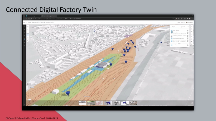
DB Systel GmbH is revolutionizing the maintenance process for train facilities by utilizing advanced GPS and localization data, along with real-time tracking capabilities. By utilizing ArcGIS GeoEvent server, they can create events based on geofences and positional data, enabling precise and immediate event generation. This approach significantly reduces turnaround times for maintenance tasks.
Integrating real-time information with 3D BIM models provides a detailed view of machinery and allows for accurate tracking of trains within the maintenance facility. This creates a connected digital factory twin, combining high-quality BIM models for both indoor and outdoor environments. The key takeaway from this project is that digitization, through the use of 3D modeling and digital twins, leads to more efficient and streamlined maintenance processes, enhancing overall operational efficiency.
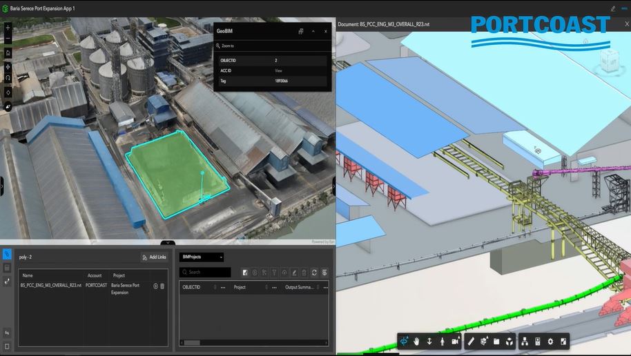
Portcoast is utilizing game engine technology and IoT devices to assist urban planners and engineers in optimizing urban development projects. By leveraging ArcGIS solutions, Portcoast is contributing to national projects across multiple countries, enhancing the efficiency and effectiveness of urban planning. The approach involves creating digital twins—starting with simple models and iteratively refining them to capture more complex data. This use of ArcGIS, which supports 3D modeling, allows for a comprehensive visualization of urban environments. The integration of game engines and IoT devices with ArcGIS not only aids in accurate data collection and analysis but also facilitates dynamic, real-time decision-making processes for urban planners and engineers.
GIS goes beyond mapping; it revolutionizes the way we plan, construct, and manage infrastructure. The geographic approach promotes understanding, encourages collaboration, and empowers data-driven decision-making, inspiring us to take decisive action. By leveraging the power of GIS, we are shaping the infrastructure of tomorrow, paving the way for a more sustainable future.
Join us at the 2025 Esri International IMGIS Conference in Frankfurt Germany, April 9-11.
About the author