Located in Indiana alongside the Ohio River, the city of Evansville is home to 115,749 people. Evansville Water and Sewer Utility (EWSU) is dedicated to providing this community with high-quality, safe, and reliable water and sewer services.
With the retirement of ArcMap and the Geometric Network, EWSU decided to migrate to ArcGIS Pro and ArcGIS Utility Network. These software offerings enable solutions that boost operational efficiency, inform decision-making, and improve customer service.
Addressing Location Inaccuracies
As EWSU transitioned its data from the Geometric Network to Utility Network, staff saw an opportunity to resolve widespread inaccuracies in their existing asset locations.
“As we were thinking about moving to and taking advantage of [ArcGIS] Utility Network, we knew our source data had to be squeaky clean.” — Ryan Key, GIS Manager, EWSU
Taking six months to recapture data with high accuracy became a priority. Inaccurately mapped clusters of infrastructure, such as multiple water meters at one site, had made it difficult to locate individual assets during maintenance, annual inspections, and capital refresh projects.
Additionally, responding to service requests with inaccurate locations often wasted time, with customer service representatives unable to access real-time customer data geospatially.
Meanwhile, capital refresh projects—which target the replacement of aging infrastructure and include design, construction, installation, and final as-built drawings—sometimes experienced project-design delays due to the location inaccuracies. As a result, updating EWSU’s geographic information system (GIS) could often take anywhere from months to a year. The utility’s staff realized that, in addition to preparing them for the migration to Utility Network, remapping and rectifying their asset data could provide a host of additional immediate benefits.
Implementing Arrow Series GNSS Receivers with ArcGIS
EWSU integrated real-time Global Navigation Satellite System (GNSS) technology. EWSU GIS manager Ryan Key was inspired to learn more about Eos Positioning Systems Arrow Series GNSS receivers after hearing about their effectiveness from a GIS specialist and industry peer. As a firm believer in trying technology before buying it, Key decided to put the receivers to the test.
“I actually went out with our field crew and tested an Arrow receiver alongside some other receivers,” Key said. “We did side-by-side comparisons of the location data, and in the end, Arrow won. Our decision really came down to the accuracy of the Arrow receiver and its quick integration with ArcGIS Field Maps.”

Since EWSU was already using ArcGIS software, integrating the Arrow receivers with ArcGIS Field Maps was a huge advantage. Additionally, the receivers were device agnostic, meaning they could pair with the iOS devices field crews were already using.
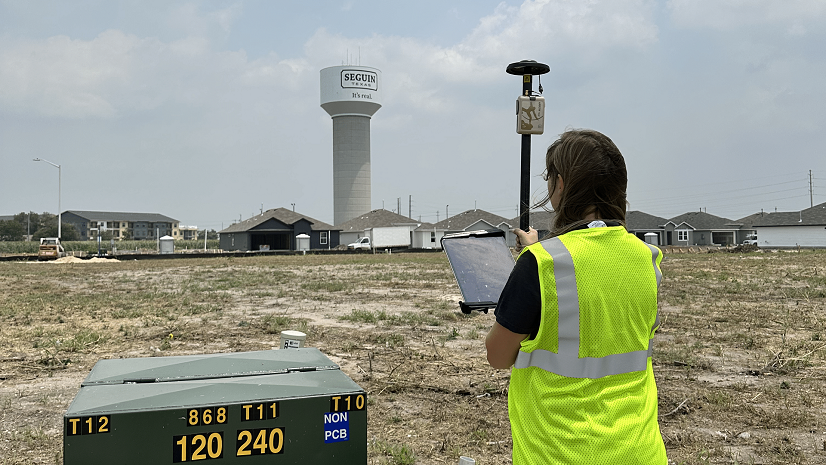
The utility purchased eight Arrow Gold receivers with surveying range poles to distribute to field crews. For projects that needed only submeter accuracy, such as private development inspections, EWSU also purchased two Arrow 100 GNSS receivers to use in handheld configurations.
“If we’re going to collect data, why not have it as accurate as it could possibly be?” Key said. “When you get tight clusters of things like system valves, that accuracy is important.”

By pairing the receivers with ArcGIS Field Maps on their iPad, crews could instantly—and accurately—update asset locations from the field during inspections.
Achieving Centimeter Accuracy with RTK Base Stations
While field crews mapped densely clustered infrastructure, Key wanted to ensure the highest accuracy possible. EWSU’s in-house surveyor set up two real-time kinematic (RTK) base stations, which provide the differential corrections needed for centimeter-level accuracy. By connecting the Arrow Gold rover receivers to a base station, crews could achieve real-time, high-accuracy results.
“We can cover most of the county with one base station,” Key said. “The second acts as more of a redundancy if one becomes inoperant.”
In the Field: Training Non-GIS Employees with Ease
EWSU trained field crews on the new technology with minimal instruction—even for those with no prior experience in high-accuracy data collection.
The EWSU GIS team trains employees new to the technology on the hardware, software configuration, and actual data collection, all of which takes only about an hour. After the training, field crews receive a basic user guide for reference. Key noted that crews rarely need follow-up support.
“The cool thing about this [GNSS] technology and the integration with Field Maps is that it is super user-friendly,” Key said. “It’s essentially plug and play.”

“A lot of these guys had no GIS experience, and they transitioned to collecting data like ducks to water,” Key said. “They get it and they love it.”
In the Office: Real-Time Updates with ArcGIS Dashboards and Utility-Wide GIS Accessibility with U-Net
Using dashboards created with ArcGIS Dashboards, staff in the office visualize and analyze data collected in the field. Back at his desk, GIS technician Aaron Krohn monitors these dashboards to see the data collection in real time.
“I can look at everything our crews have collected and see those numbers update in real time,” Krohn said. “They record the type of asset [and] its status as well as the fix type.”

Using ArcGIS Dashboards, Krohn can respond to edit requests in real time. He can also use the new, accurate locations from the Arrow Gold receivers to correct outdated infrastructure from previous plans.
EWSU also built a custom ArcGIS Utility Network web application, U-Net, by using ArcGIS Maps SDKs, a collection of developer tools used to create applications for mapping and spatial analysis. U-Net is a launching point for other teams to access information from GIS-related systems—such as an asset management system, a CCTV application, a customer service portal, and historical drawings and as-built drawings—all on a map. Non-GIS teams now use U-Net to view their information geospatially without having to open and navigate desktop GIS software. This expands the reach of GIS to teams that are not GIS professionals.
“We’re truly harnessing the service-driven architecture of [ArcGIS] Utility Network,” Key said. “It’s easier to send our colleagues a web URL than have everyone in our organization use a desktop GIS, which has too many bells and whistles for someone who wants to dive in and review, for instance, only customer service information on a map.”
To enable this service-driven, widespread information access, Key and Krohn have been diligently upgrading other systems and data and migrating them onto the cloud, via Microsoft Azure.
“Our thought process was, if we’re going to go ahead and do this Utility Network migration, why not go ahead and move other applications to the cloud too?” Key said.

Increased Accuracy and Efficiency
EWSU’s new mobile mapping workflow has resulted in better accuracy in the utility’s asset maps. This, in turn, has streamlined inspections and set a new standard for the utility’s capital-refresh project timelines. EWSU now completes the as-built process in near real time, rather than up to one year later, thanks to field crews being able to map installations during on-site inspections.
“We’ve collected about 9,000 assets in as little as two years,” Key said. “And we can see those on the map in real time—including maintenance holes, system valves, service connections, and other infrastructure assets.”
The increased accuracy of and access to Utility Network has even enabled EWSU staff to expand use of their GIS to contractors, especially those performing 8-1-1 underground-asset location requests for new development.
Looking Ahead: GIS for All
In the future, EWSU plans to leverage tracing tools in Utility Network. Key envisions how this will simplify customer notifications in impact areas. During boil-water advisories, for instance, truck valve operators will no longer have to manually draw a polygon around the impact area. Instead, they can change the operation mode of a valve at two ends and immediately generate an impact-area polygon directly from their mobile devices. This will be powered by the squeaky-clean data and meticulous cloud environments that EWSU has already created.
“Our field crews who collected this data understand that what they did will ultimately end up making their lives easier in the future,” Key said.
The same workflow can be expanded to engineers to create impact areas for water-main replacements, part of the utility’s capital refresh projects.
Key emphasized that all of this is made possible thanks to the support of EWSU’s executive leadership. Throughout the utility runs an understanding that technology enables EWSU to deliver a higher quality of service. That forward-thinking mindset allows the utility to push the boundaries of what is capable in terms of how and why staff serve customers.
“It’s all about customer service,” Key said. “Having this type of accuracy in our system allows for greater response, reaction, and repair—which translates to greater customer experience.”
Stay Connected with Esri’s Water Team
ArcGIS is an extensive information system that enables modernization of workflows with easy-to-use applications for the field and office. Strengthen your organization with smart water solutions that will increase efficiency and provide insight for decision-makers. Visit the Esri Water Utilities web site for more information.
Join the Water Utilities Community
Follow #EsriWater on social media: X | LinkedIn
Subscribe to the Water Industry newsletter “Esri News for Water Utilities and Water Resources“


