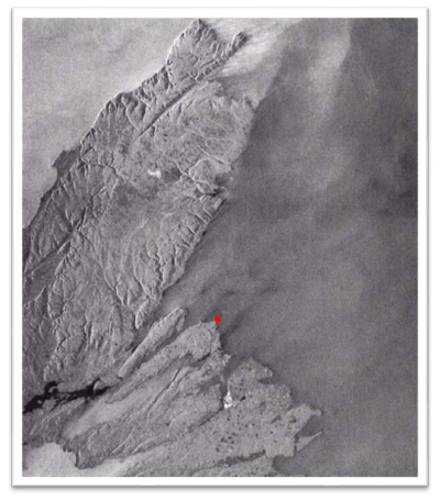
In the vast expanse of space, amid the clouds, fog, haze, and smoke, lies an Earth observation technology that unveils Earth’s secrets with unparalleled clarity. It was a moment etched in my memory, the day Canada’s first radar satellite, called RADARSAT, captured the enchanting landscape of Cape Breton Island in Nova Scotia, where I grew up. The red dot on this image indicates the location of my early homestead. As I gazed upon the black-and-white fuzzy image shared by news channels, a blur of pixels transformed into a breathtaking portrayal of the terrain that I hiked, the beaches I swam, and the rugged landscape I adored—leaping from the page in a mesmerizing 3D spectacle. What could this black-and-white earth-observing sensor technology called synthetic aperture radar (SAR for short) be?
Transforming Perspectives: SAR Unveils Earth
It was more than just an image to me; it was a revelation, a wonder. Driven by insatiable curiosity, I eventually embarked on a journey to master this transformative technology. I learned that SAR’s side-looking data collection method captured Cape Breton with a depth and detail that defied our eyes and surpassed conventional imaging techniques. Despite the veil of clouds that typically covered this island and the vast distance from space where the sensor was located, the landscape unfolded before me with astonishing clarity. At that moment, I knew that SAR technology held the key to unlocking a new frontier of understanding the Earth. That conviction resonates even more powerfully today than it did three decades ago.
As I delved deeper into the realm of SAR technology, it became clear that this innovative approach expanded our vision of the Earth but also presented a new [redundant] way of perceiving and interpreting the world around us. While our eyes capture the world visually, SAR sensors function more like our ears, delicately tuning in to Earth’s echoes in space, presenting unique challenges in comprehension. Unraveling the mysteries of SAR wasn’t easy—it presented intricate hurdles that hindered its widespread adoption. But amid the complexity, my determination only grew stronger, fueled by the immense potential of SAR to revolutionize our comprehension of the Earth. The prospect of SAR reshaping our perception of the Earth was too profound to ignore. It’s a journey of discovery and determination, where innovation converges with the limitless possibilities of technology.
Navigating the New Frontier to Unleash SAR Magic
Since the launch of RADARSAT, the landscape of SAR technology has evolved immensely. The skies are teeming with SAR sensors on satellites, CubeSats, shuttles, and planes, capturing an unprecedented surge of data. Yet, amid this abundance, few dare to directly tackle the challenge of understanding SAR. To truly harness the transformative potential of SAR in addressing Earth’s challenges, we must foster a collaborative spirit within the scientific community, enabling us to decode this wealth of data and translate it into actionable insights for environmental monitoring, disaster response, and sustainable resource management. But how?
The Collaborative Power of SAR and GIS to Illuminate Earth’s Future
At the intersection of cutting-edge technology and global sustainability, a groundbreaking chapter unfolds as SAR converges with the geographic information system (GIS) technology community—a diverse tapestry of scientists, innovators, and problem-solvers all united by a mission to address Earth’s most pressing challenges. With the unparalleled precision of SAR observations and the transformative analytical capabilities of GIS, we are not just harnessing technology; we are collectively building a future where SAR becomes a beacon of hope, illuminating pathways to understanding and safeguarding our planet. Together, this collaboration empowers us to create actionable solutions that drive meaningful change, ensuring a resilient world.
Empowering Everyone Through SAR and GIS
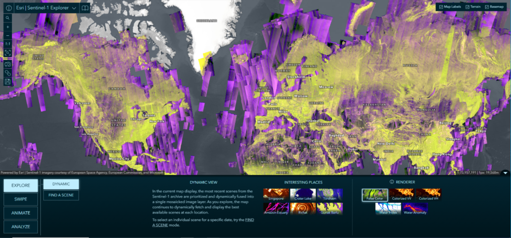
GIS is leading the way in harnessing SAR technology, transforming how we interact with SAR imagery. Driven by a surge in data availability, enhanced computing power, and a growing demand for solutions to complex Earth challenges, we are creating pathways to make SAR technology accessible to all. GIS opens up avenues where users can focus on the impactful outputs and maps generated, without needing to delve into the technical complexities of SAR itself. By seamlessly incorporating analysis-ready SAR data and leveraging AI for enhanced efficiency, GIS enables the pursuit of innovative solutions. The advancements in GIS and SAR technologies, exemplified by tools like the Esri Sentinel-1 Explorer app, showcase our commitment to empowering users with easy access to analysis-ready SAR data but also a wide range of applications, from environmental monitoring to disaster response, thus making SAR technology accessible to experts and novices alike.
Whether you’re a seasoned SAR scientist, a geospatial technology advocate, or a beginner in GIS analysis, we are developing workflows customized to meet your needs. Our mission is clear: to democratize SAR technology and empower individuals with valuable tools to unravel the mysteries of our planet.

Esri Visionaries Driving the Future of SAR in GIS
In the dynamic field of SAR technology, a passionate and diverse team at Esri is leading the way in developing essential tools, applications, and workflows to empower users to tackle the world’s most pressing challenges. This vibrant group consists of seasoned scientists, software developers, and product and program managers pushing innovation’s boundaries alongside skilled analysts adept at deciphering intricate datasets. Together, we embody a spectrum of expertise and collaboration. Through our unique contributions, this team embodies a collaborative spirit that focuses on empowering users to harness SAR technology effectively. Our goal is to unlock the full potential of SAR, equipping users with state-of-the-art tools and insights that enhance their understanding of the Earth while addressing global issues directly.
Meet the Faces of SAR at Esri


Explore the faces behind the cutting-edge SAR innovations in GIS as we introduce the talented Esri minds driving the future of SAR in GIS technology.
We stand at a remarkable crossroads, connecting RADARSAT’s pioneering SAR imagery to the SAR technology in GIS today This extraordinary space is filled with endless opportunities for exploration and innovation. Consider the iconic black-and-white snapshot of Cape Breton Island, which revealed SAR’s ability to pierce the clouds and unveil Earth’s hidden secrets with stunning clarity. Each step forward opens new avenues for understanding our planet and harnessing SAR’s potential in GIS.

We invite you to embark on this amazing journey with the Esri SAR team! Let us hear from you! What tools, workflows, and training in SAR and GIS would you like to see?
Please scan the QR code to share your insights. Your thoughts are important to us.
Look for upcoming blog posts in this five-part series, The Beauty and Promise of SAR and GIS Technology, covering tools, use cases, partners, and training and featuring the Esri faces of SAR!
About the author