Smart forms
Use flexible form builders to design forms tailored to your needs. Choose a template or start fresh. Use calculated fields, conditional logic, defaults, and multiple languages. Create anything—from simple to complex forms.
Included with ArcGIS user types
Smart forms, better decisions
Design smart forms and surveys with ArcGIS Survey123—a dynamic form builder. Accelerate data collection and enhance the quality of results. Visualize and analyze information with a geographic lens to better understand where and why things occur. Share data through web maps, apps, and dashboards to inform decision-making and improve business processes.
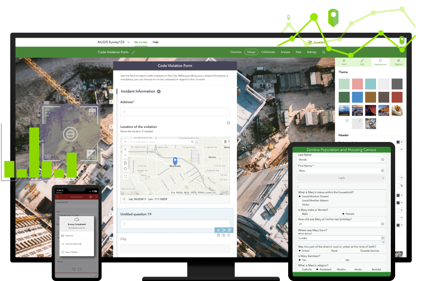
Use flexible form builders to design forms tailored to your needs. Choose a template or start fresh. Use calculated fields, conditional logic, defaults, and multiple languages. Create anything—from simple to complex forms.
Standardized forms—enriched with location data—eliminate laborious paper-based processes prone to error. Collect data faster, increase transparency among your team, and use workflow automation tools to propel data to other business systems.
Easily capture reliable data on any device, anytime, from any location. Stay productive, whether you’re on or offline—in the office or the field. Automatically sync updates to access the latest information.
Seamlessly manage, visualize, and analyze your results in one place. Discover patterns in your data using charts, graphs, and maps. Use reports and ArcGIS apps to create shared understanding across your organization.
With its drag-and-drop form creator and configurable question types, the Survey123 web designer is the perfect place to create your first web form or online survey. Leverage the Survey123 Connect form builder for complete control over smart form design and complex functionality in an XLSForm user experience. Whatever you choose, you’re covered.

Easily increase response rates by sharing online surveys or forms with the web app. For more robust data collection, use the mobile app to capture information wherever you are, on any device—even offline. Survey123 supports high accuracy for moments when subcentimeter data is critical, so you can gather high-quality data that is readily accessible.

Visualize form submissions in real time on a map or in charts and tables. Analyze your results and discover data trends and patterns. Share your insights with dynamic web maps, apps, and dashboards. Or export responses and custom reports as PDF, CSV, or Microsoft Excel files to gain immediate information and drive decision-making.

Esri Blog
Nevada Department of Wildlife took to the air to capture mule deer data and gain a deeper understanding of the species’ habitat.
CASE STUDY
In the wake of Cyclone Shaleen, Majan Electricity Company quickly documented damaged areas, located assets, and restored network connectivity.
CASE STUDY
The Utah Department of Natural Resources evolved from paper-based mining inspections and increased field data consistency by using ArcGIS Survey123.
CASE STUDY
WaterOne digitized its confined space entry permitting process to create authoritative and accessible data that improves safety and security.
CASE STUDY
The Rochester Hills Fire Department reduced paperwork and improved data collection accuracy for on-site safety visits and installations.
ESRI BLOG
US Department of Agriculture (USDA) staff use GIS to record and view data in real time to stop the spread of disease-carrying ticks.
ArcGIS provides a comprehensive set of capabilities for creating, managing, analyzing, and mapping geographic information. Gain access to the capabilities of this application, included in ArcGIS, with user types. Match user types to roles within your organization.

7:00 a.m.–5:00 p.m., Monday through Friday (PT)
Start a chat
Fill out the contact form