ArcGIS Web Editor is now available in ArcGIS Enterprise 11.3 (Windows and Linux) via download from My Esri. ArcGIS Web Editor is an approachable app that makes data editing workflows easier. This new app is designed to streamline workflows by bringing common editing tools into one interface. Web Editor helps prevent errors and keep an accurate system of record by enforcing your organization’s data rules. For additional background information on ArcGIS Web Editor, read this blog.
Web editing has been a highly requested and anticipated capability in the ArcGIS platform and now there is a dedicated, out of box application, made solely for editing data in a web browser. This app has the common editing tools that you expect. It presents capabilities in an unintimidating manner, reduces the chances for data mistakes to be made, and enforces data rules and policies. Web Editor saves time by allowing you to edit more quickly and enables others to do their own editing work. Install ArcGIS Web Editor in Enterprise 11.3 today!
Table of Contents
Below are highlights and details of the Enterprise-specific capabilities now available in Web Editor. This includes support for:
- URL Parameters
- Branch Versioning
- Editing Templates
- Subtype Group Layers
- Attribute Rules
- Utility Networks
URL Parameters
URL Parameters allow you to create a link (or URL) to directly open a web map in Web Editor. This includes options to define a specific map extent, find a location, find a feature, and set a version of the data to use.
Once constructed, the URL can then be shared with others to get them precisely what they need, so they can start working immediately.
For example, define the web map to open immediately in Web Editor. The URL will look like this – https://myportal.domain.com/arcgis/apps/webeditor/index.html?webmap=12a3bc4567890d1efg2h3ij45klmn678
Additionally specify a location to center on, by using find. The URL will look like this – https://myportal.domain.com/arcgis/apps/webeditor/index.html?webmap=12a3bc4567890d1efg2h3ij45klmn678&find=380 new york st,redlands,ca
Or even set the current version to edit within. The URL will look like this – https://myportal.domain.com/arcgis/apps/webeditor/index.html?webmap=12a3bc4567890d1efg2h3ij45klmn678&version=myaccount.myversion
For a more complete dive into the world of URL parameters in Web Editor, read this blog here.
Branch Versioning
Branch versioning enables multiuser editing and long transaction scenarios while working with feature services. Branch versioning provides multiple representations of the data without copying it, supports concurrent editing, and allows maintaining versions for an extended period. This now possible within Web Editor.
Specifically, Web Editor enables users to create a branch version, modify its properties, and select the version to edit within.
When editing within a branch version, the option to save or discard is enabled. This gives the users more control of their edits for the entire edit session. Conversely, when editing against Default or with non-versioned data, edits are committed instantaneously.
The option to undo and redo edits within a sketch using the drawing tools is always available. However, undo and redo outside of the sketch is only available when editing a branch version (this includes attribute updates, adding a feature, and deleting a feature).
The video below demonstrates how branch versioned data works within Web Editor (view in full screen to see detail).
Editing Templates
Editing templates allow for creating data in one or more feature layers or tables. They define the feature’s source, values, and descriptive metadata. There are three types of templates, all of which are described further below and supported in Web Editor.
Feature Templates: Feature templates create data in a single layer. They are supported in both ArcGIS Online and ArcGIS Enterprise and are automatically generated in ArcGIS Pro.
Group Templates: A group template works with multiple features on multiple source layers. They reference existing feature templates and rely on one primary feature to automatically construct the other relative features. Group templates are supported in ArcGIS Enterprise (though not yet available in ArcGIS Online). They are manually configured and shared from ArcGIS Pro. Support for authoring them outside of Pro will be available in a later release.
Preset Templates: A preset template creates features in the same consistent arrangement. The “set” of features is added as a point and rotated and snapped into place. Preset templates are supported in ArcGIS Enterprise (though not yet available in ArcGIS Online), and they are manually configured and shared from ArcGIS Pro. Support for authoring them outside of Pro will be available in a later release.
Subtype Group Layers
Subtype group layers bring together several subtypes into a composite grouping for improved access, drawing efficiency, and query efficiency. The unique subtype values of a source layer are represented in one group, with the individual subtype layers retaining their unique display properties.
Subtype group layers are manually configured and published in ArcGIS Pro, and Web Editor fully supports these services when they are added to a web map.
Attribute Rules
Attribute rules are used to automatically populate attributes (with calculations), restrict invalid edits (through constraints), and perform quality checks on existing data (with validation). Attribute rules are manually configured in ArcGIS Pro with the ArcGIS Arcade scripting language. They require data to be stored in a geodatabase and are supported in ArcGIS Enterprise (though not yet available in ArcGIS Online).
Utility Networks
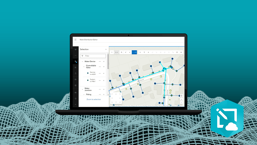
The ArcGIS Utility Network is a data model for managing physical asset networks in the ArcGIS platform. It is a comprehensive framework of functionality for electric, gas, water, storm water, wastewater, and telecommunications. It models behavior of wires, pipes, valves, zones, devices, and circuits. Web Editor works with the framework of the utility network for displaying association information and setting the snapping environment when adding new features. To leverage the below capabilities, a utility network must be added to the web map being used in Web Editor.
Trace Utility Networks: When a named trace configuration is part of the web map used in Web Editor, users can trace the utility network. The trace tool allows users to select the configuration, choose the starting point(s), and optionally specify barrier(s).
View Utility Network Associations: Connectivity of a utility network is modeled with geometric coincidence (features have same x, y, and z), as well as through associations between two non-coincident junctions. The utility network can also define structural attachments to denote if a feature or object is structurally attached to another. Web Editor’s view associations tool allows users to visually understand the connectivity and structural attachment associations, when panning and zooming the map.
View Utility Network Rules: The network rules option helps users understand associations and what features can connect to a specified feature or object as they are editing. It can be accessed from a selected feature or from the create features dialog. The list of rules is displayed in a hierarchical interactive panel.
Rule-based Snapping: When adding new utility network features, the snapping environment is automatically set, based on the connectivity rules defined in the network.
Validate Network Topology: When utility network features are added, modified, or deleted, dirty areas are created based on the extent of feature(s) being updated. Dirty areas indicate that edits have been made and the network topology needs to be updated to maintain data integrity. This can be done using the validate network topology tool in Web Editor.
The video below demonstrates how Utility Network data works within Web Editor (view in full screen to see detail).
Considerations
While most Web Editor capabilities are available in both Online and Enterprise, some functionality is available only within Enterprise. Branch versioning, editing templates, and the utility network are examples of this.
In ArcGIS Enterprise 11.3 (Windows and Linux), ArcGIS Web Editor is a separate installation and must be downloaded from My Esri. The Web Editor setup must be run on all machines running the Portal for ArcGIS component. For high-availability configurations of ArcGIS Enterprise, the Web Editor setup must be installed on both the primary and secondary portal machines. Starting at ArcGIS Enterprise 11.4, it will be included as part of the standard ArcGIS Enterprise installation. At ArcGIS Enterprise 11.4, Kubernetes will also be supported.
In ArcGIS Enterprise 11.3, a minimum of a GIS Professional Basic user type is required to access ArcGIS Web Editor. With the transition to the new user type model starting with 11.4, the minimum requirement becomes a Creator user type. Also note that within ArcGIS Enterprise 11.3, branch version editing and the utility network require a GIS Professional Standard user type. Alternatively, the Advanced Editing user type extension may be added to the GIS Professional Basic user type.
Summary & Next Steps
ArcGIS Web Editor is Esri’s new focused data editing app. It comes with ArcGIS Online and ArcGIS Enterprise 11.3 (and higher). Start streamlining your data editing workflows today! The Enterprise install is available now in My Esri.
For more information check out the below web sites and articles:
Look for more information and updates, including the next release coming to ArcGIS Online late October 2024 and ArcGIS Enterprise 11.5 (Q2 2025).


Commenting is not enabled for this article.