For a utility network to be viewed in web and mobile applications, or edited by multiple users, you must deploy the dataset to ArcGIS Enterprise and create web services for it. While these are key capabilities of the utility network, it is recommended that you do not go through this process until you have worked through your major data quality and configuration issues. This is because it is much easier to administer and make changes to a local geodatabase than to administer an enterprise utility network with the additional levels of infrastructure for DBMS and services.
You can find a comprehensive discussion on the best practices for ArcGIS Enterprise Architecture in the ArcGIS Architecture Center site. The steps discussed here outline those that a user would follow to build out something like a development or staging environment. It assumes you already have all the required ArcGIS software installed and licensed, and all the permissions and security requirements in place with your IT department.
The first step of this process is to load the data into an enterprise geodatabase. While you can load this into an existing geodatabase, it is important that you have a geodatabase that is at a supported release for the ArcGIS Pro client and the utility network dataset created in the previous step. See the Utility network compatibility page for more information about how these releases align. If this is your first utility network, you will likely need to create a new enterprise geodatabase to store your utility network. If you already have a geodatabase that contains a utility network, or plan to host multiple utility networks in the same geodatabase, you should create separate users (data owners) and schema for each utility network. You should not create your utility network in DBO-owned or SDE-owned schema, as the mixing of system tables and user tables is against best practices.
Once you have a schema configured to receive your utility network, there are several ways you can deploy data to SDE. You can find a discussion of different approaches in the Utility network dataset administration topic in ArcGIS Help. The easiest way is to copy and paste the feature dataset, and any standalone tables, from your local geodatabase into the remote geodatabase. If your data is in an asset package, you can also use the Stage Utility Network and Apply Asset Package tools to deploy your utility network. These tools, as well as the pros and cons of each approach, are discussed in greater detail in the Deploying a Utility Network Foundation article.
Once the data is copied, you want to make sure the database connection is configured to use branch versioning, then register the feature dataset that contains the utility network as versioned. The video below demonstrates these steps.
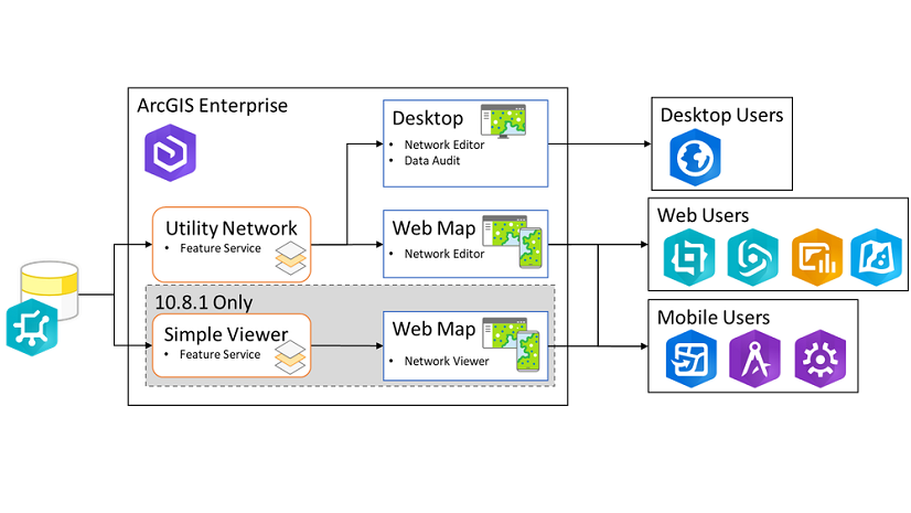
With your utility network loaded into an enterprise geodatabase and registered as versioned, you will need to publish services for editing the data and to take advantage of utility network capabilities such as trace and validate network topology. To do this you will publish a feature service that contains the utility network and its corresponding classes. You can find a detailed discussion of this process in the Publish and consume services topic in ArcGIS Help.
It is important when publishing this service that you use the default unique value renderer that relies on the asset group field. If you modify the configuration of the unique value renderer for a layer you will find that while the symbology appears correctly in the service, all your subtypes and coded value domains will not appear in web and mobile applications. The simplest way to avoid this is to add the layer directly to a new map, select yes to add all the utility network classes, then publish the service as is.
Don’t worry about the symbology of your service at this stage, as all the applications that make use of your utility network will use a map that applies the correct configuration to the layers in the feature service. You will find a video below walking you through the publishing process as well as how to resolve the common analyzer errors and warnings you will encounter the first time you publish your map.
Conclusion
Once you’ve published a feature service containing your utility network data, your last major step is to create web maps and applications that reference the service and apply the symbology used by your organization to represent your network data. This process is covered in the next article in this series entitled Creating and sharing maps for utility network data.
This article is part of a larger series of articles explaining the process and best practices for migrating and deploying a utility network. You can find the other articles in the related articles section below this post. If you have any questions about this content, or want more specific information, please post a question on the ArcGIS Utility Network community site.


Commenting is not enabled for this article.