We’re getting excited about the upcoming 2022 Esri User Conference held in-person in beautiful San Diego, California next month and we hope you are too! Join us to learn all about the latest updates and preview emerging functionality with the ArcGIS Utility Network.
Navigating the options available might be overwhelming given the breadth of presentations focused on configuring and working with the ArcGIS Utility Network but we’ve got you covered. In this blog we are highlighting some key sessions from this year’s conference which may be of interest with links to some recent blogs that explore or build on top of similar concepts.
Agenda
Showcase
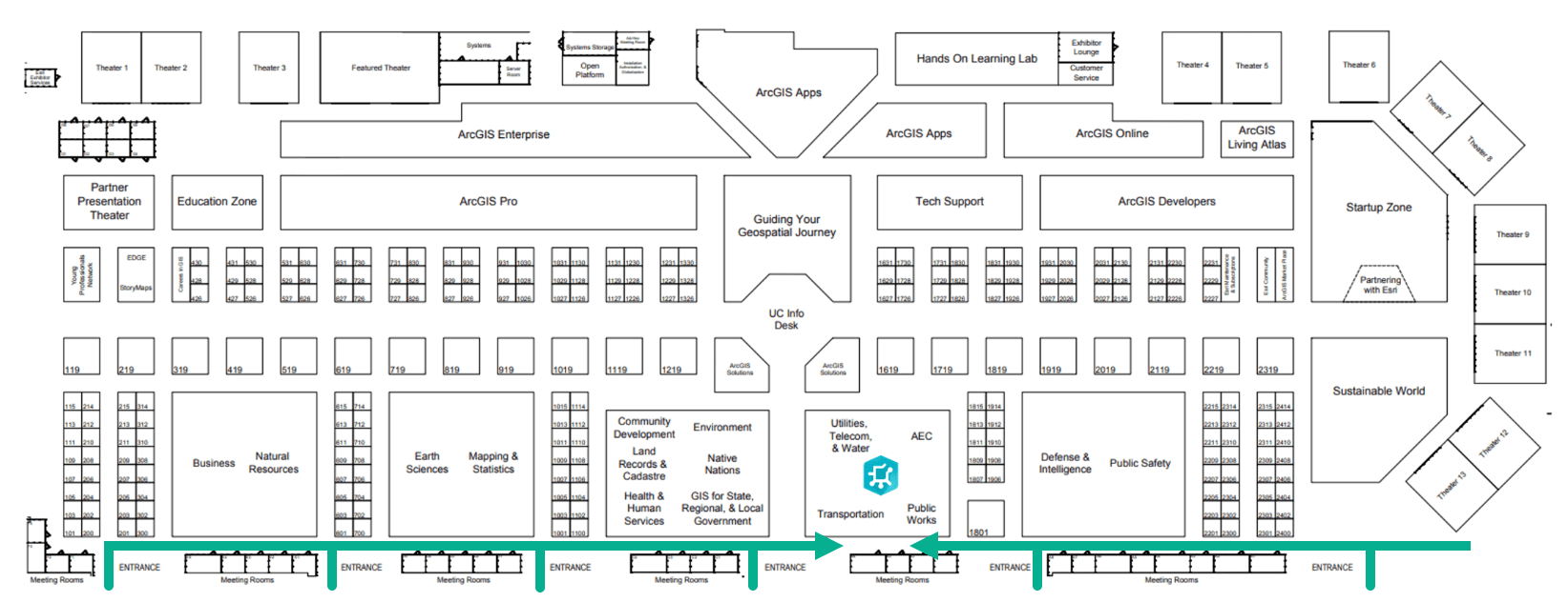
Visit us at our booth for ArcGIS Utility Network in the industry island. Talk to our experts, get a demo and learn more about the product. We can easily be found from all Expo entrances at the front of the Showcase.
Showcase hours
Tue, July 12: 09:00 a.m. — 06:00 p.m.
Wed, July 13: 09:00 a.m. — 06:00 p.m.
Thu, July 14: 09:00 a.m. — 04:00 p.m.

The ArcGIS Utility Network product team will be presenting an introductory ArcGIS Network Management session as well as one that is more advanced with a focus on extending your utility network using different APIs available for building custom tools and applications.
Beyond this, there are many other opportunities to learn about the utility network at the UC this year through additional demo theater presentations and sessions that cover application of the utility network through the lens of other products and industries.
Technical Workshops

ArcGIS Network Management: An Introduction
1:00 PM — 2:00 PM, SDCC – Ballroom 06 E
HYBRID SESSION on July 12th ONLY | Adoption of the ArcGIS Utility Network is growing across the world. This session will provide insight into the capabilities that enable next-generation network management for any utility system. It will include updates from the development team to showcase current and emerging functionality as they apply to utility information challenges and finally, we will discuss the road ahead to provide a look into the future of network management for utilities.
Presenters: Remi Myers, Mohana Krishna Punnam, David Crawford (Esri)
This session is geared toward those starting out on their journey into the ArcGIS Utility Network and is offered on both Tuesday and Wednesday. Please note that only the Tuesday session will be broadcast in a hybrid fashion.
Often, the hardest part of every journey is taking the first step. The Journey to the Utility Network blog series aims to relieve some of the apprehension experienced when getting started.
The blog article below compliments this session, helping how you think about implementing the ArcGIS Utility Network using the five key steps common to every successful implementation.
Journey to the Utility Network: First Steps
ArcGIS Solutions: Utility Network Foundations
4:00 PM – 5:00 PM, SDCC – Room 30 E
This session will provide an overview of a set of utility network foundations that help water, sewer, stormwater, electric, district energy, gas and telecommunication utilities jumpstart utility network implementations.
Presenters: Howard Crothers, Joel Smith, John Alsup (Esri)

Demo Theater Presentations
ArcGIS Field Maps: Utility Networks
10:00 AM — 10:45 AM, SDCC – Expo Demo Theater 03
Utilities need actionable information to support complex networks in the office and in the field. In this workshop we will show you how your investment in the Utility Network comes to life in the field with support. Field Maps is network-aware. You can view associations and connectivity between features, contained elements and even trace the network on your mobile device.
Presenters: Larry Young, Matthew Baber, Alix Power (Esri)

User presentations
Migrating to the ArcGIS Utility Network for Water
10:00 AM — 11:00 AM, SDCC – Room 24 C
Learn how and why utilities are implementing the ArcGIS Utility Network. This session will include discussion about exciting functionality like advanced tracing, containers for lift stations, network diagrams, and 3D scenes. You will learn how Utility Network provides a standardized platform that brings gas, water, wastewater, and electric together for better editing, planning, and modeling.
Presenters: Anthony Vazquez (Elsinore Valley Municipal Water District), Haritha Vendra (DCSE), Ali Diba (Spatial Wave), Aaron J. Gutierrez (Liberty Utilities)
Migration to the Utility Network for Electric
10:00 AM — 11:00 AM, SDCC – Room 26 A
Migration to a new GIS configuration can have challenges and rewards. Learn from these utilities about their Utility Network Migration efforts.
Presenters: Sandra Allsup (Denton Municipal Electric), Brandon Bockrath (SSP Innovations)
Utility Network in Gas Utilities
10:00 AM — 11:00 AM, SDCC – Room 27 A
This session discusses how two gas utilities implemented ArcGIS Utility Network. One gas utility is executing a multi-phased plan to move its data into the Utility and Pipeline Data Model and built 100 use cases to assure all requirements would be met. Another consolidated five jurisdictions in three states, from three different GIS vendors, all with diverse business requirements. Both final implementations included multiple ArcGIS components and many integrations with other business systems.
Presenters: Luke Klenotic (Dominion Energy Ohio), Angela Reising (UDC), Kris Girten (UDC)
Gas Utility Solutions
2:30 PM— 3:30 PM, SDCC – Room 26 B
This session addresses how one gas utility implemented ArcGIS Utility Network to support gas operations through the full outage and restoration management lifecycle. Another explores how a customer leveraged Esri’s mobile applications, the Utility and Pipeline Data Model, and attribute rules to capture at high accuracy new pipe construction, and at the same time improve the productivity of the field technicians documenting the new construction.
Presenters: Dong Le (Avangrid – Southern Connecticut Gas) , Feichi Shih (UDC), Dax Wolfinger (UDC), Damon Nelton (Ellingson Companies)

Technical Workshops
ArcGIS Network Management: An Introduction
10:00 AM — 11:00 PM, SDCC – Room 05 B
Adoption of the ArcGIS Utility Network is growing across the world. This session will provide insight into the capabilities that enable next-generation network management for any utility system. It will include updates from the development team to showcase current and emerging functionality as they apply to utility information challenges and finally, we will discuss the road ahead to provide a look into the future of network management for utilities.
Presenters: Remi Myers, Mohana Krishna Punnam, David Crawford (Esri)
ArcGIS Network Management: Extending the Utility Network
2:30 PM — 3:30 PM, SDCC – Room 16 A
The ArcGIS Utility Network is Esri’s next generation solution for utility network management. This session will focus on the different APIs available for building custom tools and applications using this technology. The session will survey the different options and capabilities available with the Pro SDK, Runtime APIs, the Enterprise SDK, and the JavaScript API.
Presenters: Aziz Mahmood, David Crawford, Rich Ruh (Esri)
What is the best way to integrate with the Utility Network? In truth is there is no one, right answer, the best way to integrate is the way that works for you. This session will provide insights that help you identify the best path forward when considering the different APIs supported with the ArcGIS Utility Network. The Journey to the Utility Network blog series is worth checking out if you are interested in this session. This series provides additional insight to introduce these concepts and will supplement what you’ll hear from the team in San Diego.
Journey to the Utility Network: Integrations Overview
- This blog presents an overview of integration strategies and the APIs commonly used to develop behind-the-scenes interfaces and applications with the Utility Network.
Journey to the Utility Network: Common Integrations
- This blog is focused on highlighting design considerations that developers and IT professionals can use to design and build three of the most important interfaces for the utility network: The Work Management System (WMS), Asset Management System (AMS), and Customer Information System (CIS) .
Journey to the Utility Network: Network Integrations
- This blog guides GIS Analysts and Developers through 3 questions to consider when extracting network information from a utility network for analysis or when exporting to other systems.

Demo Theater Presentations
Gas Pipe Network Management
2:30 PM — 3:15 PM, SDCC –Expo Demo Theater 08
See how to use ArcGIS to manage your complete pipe network using the Utility Network combined with ArcGIS Pipeline Referencing.
Presenters: Jessica Gooch, Tom Dewitte, Eric Bishop (Esri)

User presentations
The Utility Network as a Digital Twin
10:00 AM — 11:00 AM, SDCC – Room 26 A
Esri’s ArcGIS Utility Network moves utilities from a strictly mapping view of their grid to a model view. This session examines how utilities are using the utility network in new ways.
Presenters: Svein Arne Rakstang (Elvia), Jens Dalsgaard (Volue)
ArcGIS Utility Network: Lessons Learned and Best Practices
1:00 PM – 2:00 PM, SDCC – Room 24 C
Key aspects of migrating to the ArcGIS Utility Network will be shared in this session, including: Using the ArcGIS Data Loader Tools for geodatabase design and schema mapping; Creation of a combined sewer utility data model; Approach for Geometric Network and Utility Network syncing. Presenters will share how they created a strategy for migrating data, challenges to anticipate and how to overcome. Join this session to learn best practices about how to perform a successful migration and utility network deployment.
Presenters: Josephine Shih (Irvine Ranch Water District), Ali Diba (DCSE), Haritha Vendra (DCSE), Ben Stafford (Burns and McDowell), Stacy Roberts (City of Kansas City)

We’ll wrap up our sessions on Thursday with a variety of user presentations, technical workshops and demo theater presentations. This is also the last chance to visit the expo and speak with our teams at the industry island so make sure you take the time to stop by and say hello!
Technical Workshops
ArcGIS Network Management: Extending the Utility Network
1:00 PM. — 2:00 PM, SDCC – Room 03
The ArcGIS Utility Network is Esri’s next generation solution for utility network management. This session will focus on the different APIs available for building custom tools and applications using this technology. The session will survey the different options and capabilities available with the Pro SDK, Runtime APIs, the Enterprise SDK, and the JavaScript API.
Presenters: Aziz Mahmood, David Crawford, Rich Ruh (Esri)

Demo Theater Presentations
ArcGIS Data Reviewer: Tips and Tricks for Validating Water Utility Network
12:15 PM – 1:00 PM, SDCC – Expo Demo Theater 10
Learn how to implement ArcGIS Data Reviewer to support validation of water features within the utility network. This session will highlight additional methods and implementation best practices for enhancing the validation capability in the utility network. Also, we will discuss QA/QC recommendations for utility network migration.
Presenters: Kaleb McNeil, Michelle Johnson, Srinivas Suryanarayanaiah (Esri)

User Presentations
Integrated Design and Engineering with GIS
8:30 AM – 9:30 AM, SDCC – Room 26 A
One of the critical activities of electric utilities is the design and engineering of new facilities. Learn how these utilities have incorporated advanced design tools into their GIS infrastructure.
Presenters: David Pahl (Kaukauna Utilities), Kayla Coonen (Kaukauna Utilities), Len Jewell (POWER Engineers, Inc.)
Digital Transformation of Electric Operations
2:30 PM – 3:30 PM, SDCC – Room 25 A
Utilities have been seeking a better way to manage their assets. One way is digitally transforming their AM processes using spatial technologies. Learn how these utilities leveraged ArcGIS to enhance their AM workflows.
Presenters: Cat Whitaker (Emerald People’s Utility District), Len Jewell (POWER Engineers, Inc.), Patrick Gans (Lincoln Electric System)


Commenting is not enabled for this article.