In this new release, we are introducing the all-new projects. With projects, planners can upload 3D models to the 3D system of record and analyze the impact on the surroundings. Projects come with a new and improved user interface and contribute to a vastly enhanced planning context in ArcGIS Urban.
Before we dive into all the details, do any of these challenges sound familiar to you?
Challenge 1: Superficial overview of development activities
Many project sites are being considered for development, and some are already in the process of approval. What is missing is a shared and detailed spatial representation of projects at various stages in the process.
Challenge 2: Inaccessible 3D data
Detailed 3D models related to site plans are available, but they are stored on a shared file drive in various formats and require technical expertise and special tools for display.
Challenge 3: Inconclusive reviews
Different stakeholders are involved in project reviews, and they aren’t using the same analysis tools or parameters to evaluate the impact of projects, which causes them to compare apples to oranges.
With the new projects in ArcGIS Urban, we are solving all these challenges when managing site plans. In the following sections, we will show you how.
Manage your site plans with projects
Depending on the status of a development site, planners work with various levels of details when it comes to the available information. From the first intent of a development, where only the location might be known, to a sketch that represents the volume of a building, all the way to a detailed BIM model, you can now represent all stages of a site plan’s lifecycle in ArcGIS Urban.
A new editing experience for projects
Whether you already have projects in your Urban model or are creating a new project, you can now dive into the new editing experience for projects. Configure information about the project such as name, thumbnail, status, and description in the new info mode – all in one place.
In the development mode, you can upload 3D models, sketch volumes and surfaces, and add assets such as trees for a low level of detail representation of your project – with a new editing workflow that allows you to add multiple assets more efficiently.
There is a new editing toolbar that is located right underneath the selected elements in the project. From here, you can explore all available editing options – including multi-selection – and can make changes right there in the scene.

All previous functionality of the old project editor has found a new home in the new project editor experience that also comes with an enhanced navigation and a tidier user interface.
Upload your 3D models
When a site development has reached the point when an architect or developer submits a detailed 3D model, for example to obtain a building permit, a case officer or a planner wants to be able to quickly display, visualize and verify this model in the surrounding context.
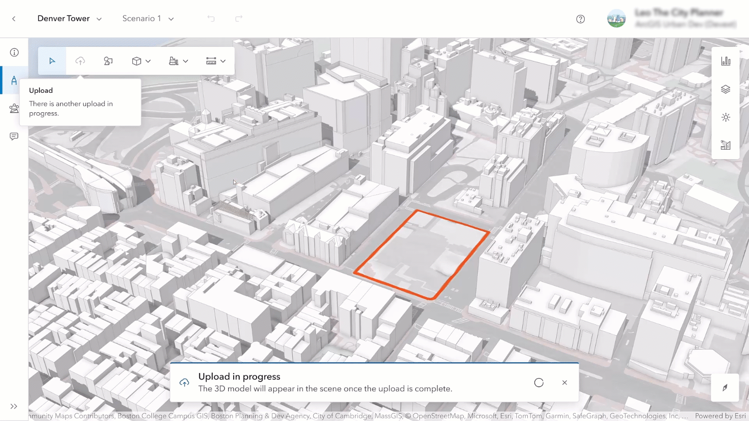
The new 3D model upload functionality unlocks this workflow for planners in ArcGIS Urban. A range of formats are supported including IFC, dwg, fbx, and obj. The original file is uploaded and stored in your 3D system of record without any modifications.
In the background, the 3D model is seamlessly converted and stored as a 3D object feature layer. This step allows you to adjust the position of your 3D model in the project editor. Once the upload is finalized, the 3D model is displayed in the scene, and you can adjust the elevation, orientation, scale and exact coordinates to position it accurately.

The performance for displaying and editing the 3D models can be optimized by considering some best practices for the creation of 3D models. You can review them in our documentation.
Analyze the impact
Now that your site plan has a detailed 3D model, you can use the new analysis mode to understand the impact of the project. In this mode, you can – for now – make use of the already familiar analysis tools: shadow cast, elevation profile, line of sight, and viewshed.
You can now save your analyses and retrieve them at a later time from the list of already conducted analyses.

The line of sight and viewshed tools also come with an additional UI where you can configure the observer points using exact coordinates, including the exact height above the ground, for example to mimic the pedestrian perspective.
Use projects as planning context
Projects do not just exist on their own in ArcGIS Urban – they can be visualized and used in the context of other planning activities. In the overview, you can display projects with their detailed 3D models or the building volumes where they are colored by their status. This allows you to get a quick spatial overview of what’s going on in your city or community.

Additionally, projects are shown within the boundaries of zoning and land use plans – including their detailed 3D models. This new feature enables planners to have the full picture of what’s happening within the boundaries of their long-term plans.
And lastly, in honor of Tobler’s law that states that “everything is related to everything else, but near things are more related than distant things”, also in the project editor you can now show surrounding projects with their 3D models to put your development site into the context of a neighborhood.
What else is new
While this release focuses on the new projects, here are a few other updates you don’t want to miss:
Upload blueprints as context for plans
In the last release we added support for media layers to be loaded from web scenes. In this release, you can upload images such as blueprints directly into your plan, georeference them and store them as media layers on a scenario.

The new image upload in the plan editor comes with several convenient features such as persistence of control points when uploading a new version of an image or being able to change the order of overlapping images when your scenario contains multiple blueprints.
For the full list of new features and enhancements in ArcGIS Urban, check out the release notes.
Urban API updates
In this release, the Urban API added support for the new projects through the ObjectSceneLayerItemId field to retrieve the 3D object feature layer assigned to the project, as well as the MediaLayers on the branches that can be queried to access the media layers uploaded to plans.
Additionally, the analysis configurations of the analysis tools that are being persisted in the database can be queried through the Urban API and can be used to replicate the same analysis in other tools.
You can read the release notes for the Urban API here.
Summary
The new projects in ArcGIS Urban for site plan management allow you to move from a superficial overview of development activities to a shared and detailed spatial representation of projects at various stages in the process.
The new 3D upload for projects removes the requirement for technical expertise or special tools to display and understand 3D models in the context of their surroundings. The original files of various formats can be stored for retrieval and archiving, making ArcGIS a powerful 3D system-of-record for current planning.
And with the new analysis capabilities, project reviews can be conducted in a conclusive and comprehensive manner creating a shared understanding of the impact of projects and making collaboration between developers, planners, and other stakeholders more efficient.
We hope you enjoy the new features in this release and as always, let us know if you have any feedback or questions by connecting with us on the ArcGIS Urban Esri Community page.
Watch the video
Check out this short 2-minute video to see these new updates in action.


Commenting is not enabled for this article.