Since the introduction of Arcade in Field Maps we’ve seen users adopt new capabilities such as calculated expressions to bring forth great efficiency in their field workflows. This webinar takes viewers through an overview of Arcade in Field Maps with examples of how it can be used to provide greater situational awareness to teams in the field, streamline data capture and produce quality data ready for reporting and analysis. Don’t worry if you missed it, the webinar recording is available.
In this blog we are answering the great questions we got asked but didn’t have chance to cover during the webinar.
General Questions
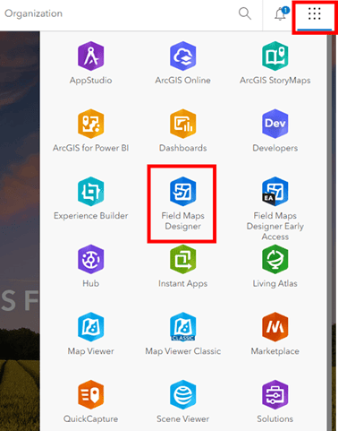
Question: How do I get access to Field Maps Designer?
Answer: You can access Field Maps Designer from the app launcher in ArcGIS Online or ArcGIS Enterprise portal.

Question: Is Collector on Android and iOS still supported? When should I migrate to Field Maps?
Answer: No, Collector and Explorer on Android and iOS have been retired. Migrating to Field Maps is easy (here’s a handy reference guide) and you’ll get a lot of new features to boot! If you have any barriers to migration, please let us know in this one-minute survey.
Question: Is 3D being considered for Field Maps roadmap?
Answer: We are certainly looking at the use cases for 3D in the field. If you are interested in this functionality, you can show support for this idea on Esri Community by adding kudos and optionally sharing your use case.
Question: Are subtypes supported in Field Maps?
Answer: Yes, subtypes are supported in Field Maps. Subtype group layers are also supported, but as read-only.
Question: Can Field Maps use voice recognition for text entry instead of typing?
Answer: Yes – you can do this today by enabling microphone permissions on the keyboard.
Question: In Field Maps will streaming data collection run if you background the app on your device?
Answer: Yes – you can background the app and data will continue to be collected as long as you have started streaming your data collection prior to putting the app in the background.
Arcade
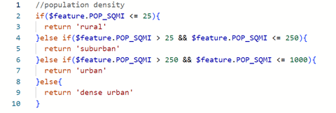
Question: What’s the difference between the Arcade function if() and the function IIF() ?
Answer: The IIF() function is usually used for a single true/false case. IIF() returns a given value if a condition is true, otherwise it will return an alternative value if false. An if() function can have multiple else if() statements as well as an else() statement as your default/false value when all other conditions are false. Its always worth trying to keep your expressions short for performance.

Question: When can you apply Arcade expressions to a layer?
Answer: If you are creating a feature class in ArcGIS Pro you can add your Arcade expressions in ArcGIS Pro to your labels, symbology, and pop-ups and they will remain when published as a service to either ArcGIS Online or ArcGIS Portal. You can also publish your data first and then create your expressions in ArcGIS Online or ArcGIS Portal in the Map Viewer to enhance your maps. If you are using Arcade in a form you can apply the expressions in Field Maps Designer and in the Map Viewer.
Question: Can Arcade be used on labels in ArcGIS Online?
Answer: Yes – you can use Arcade to enhance your labels, symbology, and pop-ups in ArcGIS Online and ArcGIS Portal.
Question: Will Arcade expressions work in an offline environment?
Answer: Yes – Arcade will work offline for your symbology, labels, pop-ups, as well as the calculated expressions in your forms. If you are using a layer which does not have offline/sync capabilities or if you have a calculation which references layers and/or tables that are not in your map, your Arcade expressions would only work online.
Question: When will the conditional logic functionality be available in ArcGIS Enterprise?
Answer: Conditional Visibility has been available since Enterprise 10.8.1. Conditional Editability and Conditional Required are available in the Enterprise 11.2 release.
Question: Can you use Arcade to symbolize data using values in related records?
Answer: No, you can’t symbolize data directly from your related tables. However, you can use Arcade to process your related data that you wish to use in your symbology. There is a great blog article by Kristian Ekenes with more information.
Question: If you use an Arcade calculation on one of the fields in your form, can the field then be edited manually?
Answer: No – a field cannot be manually edited if you run an Arcade calculation on that field. When setting up a calculation with Arcade in the Field Maps Designer, you will see the read-only and calculated labels appear on that field. If you manually change the field to allow for editing, the calculation will no longer run. If you have a specific use case where you would want to allow for manual editing, we would love to hear it, you can add this idea to Esri Community by sharing your use case.

Question: What tips do you have for debugging in Arcade?
Answer: When debugging your expressions take advantage of the console function. The console will give you log messages to help you find and fix errors in your expressions. There are additional debugging resources available in the Arcade documentation.
Question: Can Arcade be used for data validation and error handling in your form?
Answer: Using Arcade calculations will help reduce/eliminate errors, since calculations are done automatically. While Arcade can help reduce errors by calculating values, error handling is better suited to contingent values and attribute rules. Contingent only allowing fields to be filled with certain values depending on the value of another field. Validation attribute rules allow you to define what is valid.
Question: What is the best way to implement a unique incremental field ID in Field Maps?
Answer: We recommend using Attribute rule calculations for assigning a sequential ID. Here’s a technical article that outlines the process of configuring such a rule. It’s worth noting that this rule will not run in an offline state as it only executes when data has been submitted.
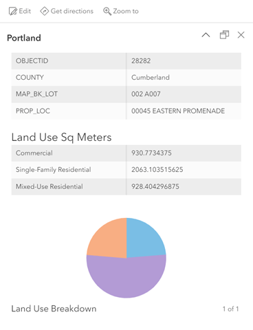
Question: Using Arcade can you summarize polygon areas within another polygon, such as land cover inside a tax parcel, and show the results in a pop-up?
Answer: Yes – it’s possible to summarize the data of polygons intersecting polygons. First, your layers will both need to be vector polygons, you will need to use the Intersects() function to find the intersecting geometries and a dictionary to check the selected feature with the other intersecting features. Using the dictionary will make sure that if you have multiple areas of the same type in your polygon, that you can add those together, instead of writing over it. You can see an example expression here.

Question: Do you need to have existing data in your layer in order to use an arcade expression for symbology?
Answer: No, you can create your expressions without existing data in your layer. And if you need to make any changes later you can always update your expressions as needed.
Question: When using the GetUser() function, do you need to have the user data stored in a domain?
Answer: No, you do not need to set up a domain with your user’s names. The GetUser() function is pulling information from your organization. To learn more about that information is available with the GetUser() function you can check out the function reference.
Question: Can Arcade cause performance issues with maps? And does the size of your dataset matter?
Answer: Yes – if you are using lot of Arcade expressions, especially if those expressions are complex or using any spatial queries, that can impact performance. Paul Barker has a great blog that helps troubleshoot and optimize performance issues with Arcade. Another thing to keep in mind is the number of features on the screen at a time. Setting zoom levels, especially for labels, can help speed up processing time and performance.
Question: Can Arcade be used in ArcGIS Notebooks?
Answer: ArcGIS Notebooks work with Python libraries and do not work with Arcade. To find out more on where you can use Arcade across the ArcGIS Platform, check out the profile documentation.
Question: What versions of ArcGIS Enterprise support Arcade?
Answer: We have a very handy version matrix for Arcade which will show you what Arcade functionality is available for each version of ArcGIS Enterprise. Additionally, you can check the Arcade blog posts for updates on what functionality has been added.
Question: Why aren’t FeatureSets available when working with symbology?
Answer: FeatureSets functionality can be super helpful when creating your Arcade expressions, however they are not available for use with symbology (visualization) and labeling. Using FeatureSets in those profiles would lead to excessive network requests and would greatly hinder performance. To learn more about FeatureSets, including a potential work around for visualization, check out the FeatureSet profile documentation.
Question: Where can I find a reference to the examples shown in this webinar?
Answer: References to what was shown in this webinar can be found in the following resources:
Common calculated expressions for ArcGIS Field Maps
Add Arcade expressions to the form
Use conditional visibility to streamline data collection
Forms
Question: Do making changes to the web map reset the form configuration?
Answer: No making changes to the web map in Map Viewer should not reset the form. If you are republishing from ArcGIS Pro or republishing the layer you may overwrite the form.
Question: Can forms be used offline?
Answer: Forms are available offline and expressions will also run offline. If you are using expressions which reference other services as part of a calculation make sure these other services are in the map and are sync enabled.
Question: Is there a way to have cascading lists in ArcGIS Field Maps?
Answer: Contingent values are field values that are dependent on other values and allow you to restrict the valid entries in a field to a set list or range of values. For example, if you have a field for “Pipe Type” and a field for “Pipe Diameter”, you can configure the “Pipe Diameter” to show only the valid diameters, rather than every possible diameter across every possible pipe type.
Question: If you use a switch form element what type of field is it?
Answer: Switch is one of the choice form elements available in the form. The field can be either a Double, Integer, or String. Check out the doc to find out more and how to configure them in your form.
Question: Is there a way to save form calculations so I don’t have to rebuild it every time a new map is deployed?
Answer: Currently, there are two options to save a form. One is to save the form to the map and the other is to save the form to the layer. When saved to the layer this form will be available when you add the layer to multiple maps. There is not the ability to export a form and apply this to a different layer. If you are interested in this functionality, you can show support for this idea on Esri Community by adding kudos and optionally sharing your use case.
Question: If your create forms in one organization how can you transfer said form to a different organization?
Answer: Currently, there isn’t an option to export a form and transfer this to another organization. The current options available are save the form to the map and save the form to the layer. If you are interested in this functionality, you can show support for this idea on Esri Community by adding kudos and optionally sharing your use case.
Pop Ups
Question: Do pop-ups work offline?
Answer: Pop-ups do work offline. If you are using Arcade expressions its worth considering the services which are being referenced in the expression. Referencing services outside of the map or services that are not sync enabled will cause the expression to not return any results. This is due to Arcade not being able to access these services when in a disconnected environment. Its therefore recommended to include the features in the map and ensure they are sync enabled before going offline.
Question: For the pop-up configurations, are charts automatically updated when data is updated? Ex. Condition of a structure changes
Answer: If you are using Arcade to populate the values of a chart these will update every time a change is made to the data.
Question: Are pop-up elements available in ArcGIS Enterprise?
Answer: Yes pop-ups authored in the maps viewer in Portal for ArcGIS are supported in ArcGIS Field Maps.
Geofences
Question: Does using geofences require additional ArcGIS Enterprise software?
Answer: Geofences do not need any additional licensing or software. Geofences in Field Maps were first introduced in ArcGIS Enterprise 11.1.
Question: Can geofences be used with ArcGIS Indoors? Can they be “floor aware?”
Answer: Introduced in our R3 release last year (November) was support for floor aware geofences. They do require indoor positioning systems (IPS).
Question: Will a geofence notification show up on the mobile device if the Field Maps app is closed or does Field Maps have to be opened for the geofence to work?
Answer: Geofences work online or offline and in the foreground or background of the mobile device.
Thank you!
We appreciate your attendance and thoughtful questions. If your question wasn’t answered here or you have subsequent questions share these on Esri Community.
Let us know if there are any future webinar topics you’re interested in!


Article Discussion: