The June release contains demographic updates for the U.S., Australia, and 33 countries in Asia. Read more about these updates below or jump ahead to learn how these updates affect you.
U.S. Demographics
- Geography Changes: While most geographies typically do not change from year to year, this release contains updated boundaries for ZIP Codes, DMAs, and Counties. ZIP Codes come from HERE’s Q3 2016 release. Warren County, IN was dropped from Champaign & Springfield-Decatur, IL DMA and added to Indianapolis, IN DMA. Wade Hampton Census Area, AK (02270) changed to Kusilvak Census Area, AK (02158). Shannon County, SD (46113) changed to Oglala Lakota County, SD (46102). Bedford city, Virginia (51515) has been dropped from the county inventory and is now part of Bedford County, VA (51019). The county name for La Salle Parish, LA (22059) was corrected to LaSalle Parish, LA (22059).
- 2017/2022 U.S. Demographics, including 2017 Daytime Population, are updated to represent July 1st of 2017 and 2022.
- 2017 Tapestry Segmentation data are updated to represent July 1st of 2017.
- 2017 Consumer Spending: This release incorporates the latest Consumer Expenditure Surveys (CEX), 2014−2015, from the Bureau of Labor Statistics (BLS) to estimate current spending patterns.
- 2017 Market Potential: This release incorporates Doublebase 2015 survey data from GfK MRI. This new survey has resulted in the deletion of some Esri Market Potential variables as well as some additions.
- 2017 Retail MarketPlace data are updated to represent July 1st of 2017.
- 2017 Business Locations and Summary are updated with Infogroup’s January 2017 business data.
- 2017 Major Shopping Centers data are updated with Directory of Major Malls’ January 2017 data.
- Also updated were Traffic Counts and Crime.
- View a detailed list of variables available in this release in the 2017 Esri Demographic and Business List and visit the Esri Demographics Documentation pages for updated methodology.
Australia Demographics
- Australia demographics from Michael Bauer Research were updated from 2014 to 2016. Visit the Esri Demographics Documentation pages for release notes and methodology.
Asia Demographics
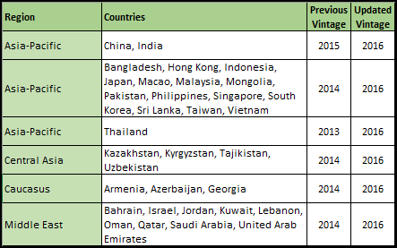
- Demographics from Michael Bauer Research were updated to 2016 for the following 33 countries. Visit the Esri Demographics Documentation pages for release notes and methodology:

How will these updates affect me?
For the Ready-to-Use Living Atlas Maps User within ArcGIS Online
Demographic layers and maps for 35 countries are updated.
For the Business Analyst and Community Analyst User
Business Analyst and Community Analyst users can access the updated data through reports, infographics, and maps. The complete attribute list for each country is accessible through the data browser contained in the application.
For the Data Enrichment user in ArcGIS Online or ArcGIS Maps for Office
The June 2017 update provides access to the datasets shown above. For a detailed explanation of new or deleted attributes in datasets, see the Release Notes for each individual country available on the Esri Demographics documentation pages.
For the Developer using REST endpoints for Standard Global Demographics & Lifestyle Map Services
The REST endpoints for Standard Global Demographics & Lifestyle Map Services were updated in June 2017. These changes will impact any application consuming these services. Some of the changes to the underlying REST endpoints included in this release are:
1. Changes to the layer IDs.
2. Changes to layer names.
3. Changes to attribute field names, IDs, and aliases including additions and deletions.
Because of updates to the underlying data, users of the Demographics & Lifestyle Map Services may need to update these items in the query parameters of REST requests to the service from their apps. To view the updated map service REST endpoints, you will need to access the REST API with a developer or organizational account, using a token request.
For the Developer using the REST endpoints of the GeoEnrichment Service
The underlying datasets of the REST endpoints of the GeoEnrichment Service were updated in June 2017. Some of the changes to the REST endpoints included in this release are:
1. Changes to the layer IDs of the administrative/statistical boundaries.
2. Changes to the layer names of the administrative/statistical boundaries.
3. Changes to attributes/analysis variables including additions and deletions.
Because of updates to the underlying data, users of the GeoEnrichment Service may need to update these items in the query parameters of REST requests to the service from their apps. To view the updated REST endpoints, you will need to access the GeoEnrichment Service with a developer or organizational account, using a token request.

Article Discussion: