ArcGIS Data Reviewer is an extension to ArcGIS Pro and ArcGIS Enterprise that allows you to automate, simplify and improve your data quality control and management workflows. Data Reviewer supports the creation of constraint and validation attribute rules through configurable ready-to-use checks that do not require custom code.
This release of ArcGIS Pro 3.3 and Enterprise 11.3 introduces enhancements to existing data quality checks for automated review and improved support for visual review workflows.
ArcGIS Pro
The ArcGIS Pro 3.3 release includes updates to Data Reviewer that extend the functionality of existing data checks and improvements to visual review tools.
Enhancements in automated review
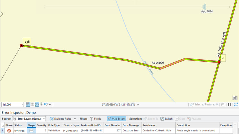
The Feature on Feature check identifies features that are spatially related and evaluates features that meet the conditions defined in the rule parameters.
This check can now include a feature’s elevation values or z-values when evaluating its spatial relationship to other features. The enhancement supports use-cases in any industry where features include elevation values. This check update is also now available in ArcGIS Enterprise 11.3 to support services-based data validation.
In the following indoor mapping example, office units must be within specific floor levels and must have matching floor level heights. In the below graphic to the left there is an office unit highlighted in green that has matching level attributes and matching z-plane values as the blue polygon. The second graphic on the right displays the same office unit with matching attributes as the blue polygon, however, the z-value vertices do not match. Using the Feature on Feature check to find z-value errors, this incorrect elevation vertex is highlighted as an error in our data.


Enhancements in semiautomated review
The Flag Missing Features and Browse Features tools in ArcGIS Pro support visual review workflows that help in identifying missing, positionally inaccurate or miss-extracted features in your data. These tools have been enhanced to support web service deployments enabled by the ArcGIS Data Reviewer extension for ArcGIS Enterprise.

ArcGIS Enterprise
The ArcGIS Data Reviewer extension for ArcGIS Enterprise 11.3 includes updates that enhance automated review of data in attribute rules and new workflows that support semiautomated review of feature quality.
In this release, you can now implement workflows that leverage the knowledge and expertise of subject matter experts in the evaluation of data quality. This includes the use of visual review techniques that identify missing, positionally inaccurate or miss-extracted features. You can now use this form of quality review for those features shared in web maps using tools in ArcGIS Pro 3.3 or a custom application that leverages the new Write Errors REST endpoint operation. Errors detected using this form of review are stored in a common error store along with errors detected using automated review workflows.
For more information, please visit the Data Reviewer product page. If you have any questions, or ideas on what you’d like to see in future releases, join our Esri Community.

Commenting is not enabled for this article.