Business Analyst users have many options when it comes to basemaps for use in ArcGIS Pro and ArcGIS Business Analyst Web App. Both applications come with a standard set of basemaps that allow for informative and aesthetically pleasing cartographic display. Any of the 30-plus basemaps offered in ArcGIS Online can be curated into your organization to expand on the set of cartographic styles and display options.

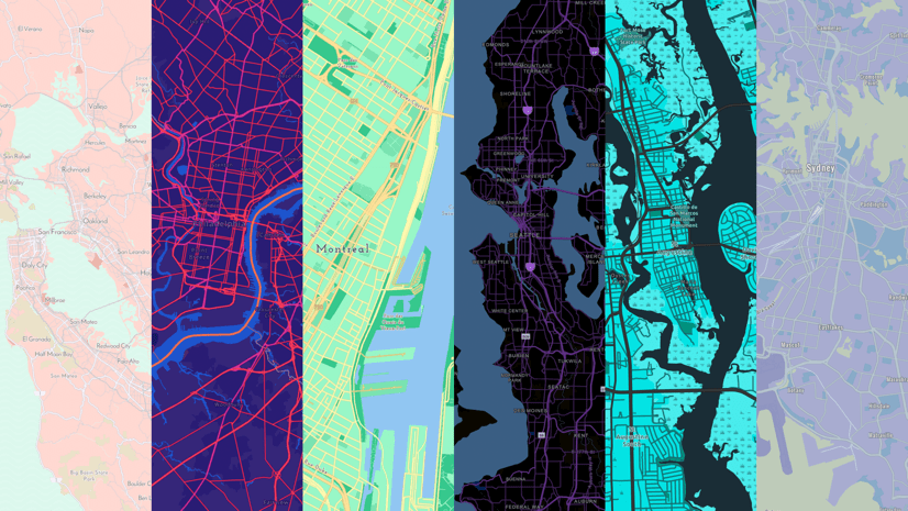
We also know that some users want the ability to create and customize their basemaps. For example, users may want to change the color of the roads, modify symbol sizes and shapes, or remove certain types of map detail at different scales. This allows market, site, or customer data to stand out against the basemap or create a more visually pleasing aesthetic when working with data. I frequently swap basemaps when using different workflows, such as color-coded maps versus suitability analysis, because of the color ramps I use in my analysis, and I often want to tone down the background detail so I can better discern and understand the variations and patterns in my data.
Historically, users could edit the background mapping data supplied in the local data package using the file geodatabase format (FGDB). With the file geodatabase format, Business Analyst Pro users could customize every detail of their maps and not rely on the ArcGIS Online basemaps. While extremely flexible, it was also time-consuming and with each new data release, users needed to recreate their maps again. In 2024, Business Analyst adopted the modern Mobile Map Package (.mmpk) format for map layers, which greatly improves performance that is also aligned with the whole ArcGIS platform. The downside of this is that Mobile Map Packages cannot be customized. So how does a user get the same ability to create and customize basemaps and use them in Business Analyst applications? The answer is to use ArcGIS Vector Tile Style Editor to design a map background, which will form a new basemap that shows features of interest to you, in the way you want to view them. This article walks through the basics of the process.
Why create a custom basemap?
Aside from the fun of learning a new mapping skill, using ArcGIS Vector Tile Style Editor (VTSE) allows you to create basemaps that are specific to and supportive of the workflows and needs of your organization. For example, users sometimes want to specifically configure and layer businesses, roads, parks, and other points of interest in their maps and visualizations.
The VTSE provides the same flexibility and customization opportunities not at a consistent global scale, that not only works with ArcGIS Business Analyst Pro but also anywhere that you use Business Analyst, including on mobile, the web, or in applications that you develop across the whole system. This includes reports and infographics, ArcGIS Experience Builder apps, ArcGIS StoryMaps stories, and in ArcGIS Dashboards. The basemaps allow infinite customization and you can easily save and modify your styles, allowing one basemap to be the template for a later style, an innovative new design, or even a combination of elements from different sources such as using imagery at the regional scale, adding roads at the city scale, and using just streets and topography at the block level.
Many organizations use the VTSE to support brand and design guidelines against which they plot the results they create using Business Analyst. I love the power and flexibility that VTSE gives me and the speed and performance of the basemaps I create, which I can use anywhere in the world with any of my data. It’s also a fast track to consistent, boardroom-ready information products that I can share with my organization, allowing any of my teammates to leverage my investment in basemap creation.
Creating a custom basemap: An overview
The process for creating a custom basemap in VTSE is comprised of three overarching steps. Play the video below for a walk-through, or read on to get an overview of the steps.
Step 1: Select a default basemap style
You can choose from the familiar defaults, such as World Topographic, World Navigation, and Light Gray Canvas.

Step 2: Style the layers individually or as a group
Optionally, adjust the colors in the Colors pane. You can assign colors to features such as land, water, roads, boundaries, and buildings.

You can also expand layers, such as roads or buildings, and style them individually.

Step 3: Save your custom basemap
Once you have created your basemap, you can save the style in your ArcGIS content portal to use and share with others in your organization. You can save and export what you create as a file that you can customize further or share with others.

For a walk-through of this process, read the Tutorial: Create a custom basemap style in the ArcGIS Developers documentation.
Bringing your custom basemap into Business Analyst
Once you have customized and saved your basemap, you can use the following steps to open the item in Business Analyst. To curate basemaps in your ArcGIS organization, you must be an organizational administrator.
First, open ArcGIS Online and go to Organization > Settings > Map. Then, in the Basemap gallery section, under Group, click Edit on the Basemaps group.

On the Basemaps group page, click Curate featured content.

Select the basemap you created to add it to the group. Once you have added it to the group, it is available to all organization members in both Business Analyst Pro and Business Analyst Web App.
Where do you go from here?
The possibilities of the VTSE are endless. I’ve created many different styles by blending imagery and vector layers, mixing color styles and components that I like from one basemap with elements from another. The VTSE and ArcGIS Online Map Viewer provide extraordinary control in creating maps that mix elements and items—I can take reference text from one basemap and add elements from another. The tutorial helps you understand how to do this.
My colleagues have created many custom basemaps too, which are now in ArcGIS Online or in user-facing apps such as this beautiful multi-scale example in the Fire Aware App from the Living Atlas. John Nelson has a great example of creating an embossed imagery basemap, which has inspired me when creating my own examples too. I encourage you to explore these videos and tutorials because when you get to experience what the VTSE and ArcGIS Online map compilation tools can do, you’ll wonder why you spent any time editing your own vector layers.


Article Discussion: