Organizations around the world are working on the geospatial foundations for their communities.
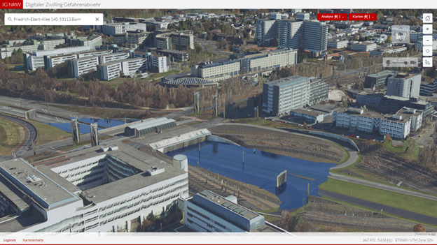
The Ministry of the Interior of North Rhine-Westphalia (NRW) in Germany, is implementing an emergency response digital twin to assist in disaster management. Emergency specialists are not necessarily GIS professionals. By using photo-realistic meshes you can quickly get an overview of the situation. You can find the right information for different tasks. The work is closely coordinated with Geobasis NRW and IT.NRW.

You can answer important questions with the disaster response digital twin like:
- What kind of fire engine is needed?
- Will the fire engine fit through the street, or under the bridge?
- Is the ladder long enough to reach every floor?
All information essential to answer these type of questions can be combined in a 3D scene. A high-quality reality mesh is required to build these types of applications.
Requirements for the reality mesh
Before starting a project like building a digital twin you need to think through the requirements you have. In the case of the disaster response digital twin of NRW the following considerations were made.
Update
Geobasis NRW provides a large variety of current and historic maps, ortho-photos, DTM and DSM and now the mesh layer. Together with con terra, a leader in the area of integration of geospatial technologies and ESRI Platinum Partner, a photo-realistic mesh layer is being created for the entire state of North Rhine-Westphalia. From a set of defined subareas of the state meshes are produced. In a second step the meshes are combined to one service. This mesh layer is a building block of digital twins for different applications. Over the next few years, the mesh layer will be continuously updated.
Spatial reference
Obviously 3D data do not exist decoupled from 2D data. Government agencies are maintaining all types of data and layers required for the geospatial infrastructure. The mesh layer needs to fit together with the existing geospatial infrastructure. For example, the road network, buildings, or tree information are all available as 2D layers and must be combined with any new 3D layers. Often 2D data need to be represented in a specific spatial reference, for example in the state of North Rhine-Westphalia it is mandatory to use the state spatial reference ETRS89 UTM zone 32N.
Use of open standards
Another requirement is the use of open standards and to publish data as open data if possible. Thus, the federal authorities in NRW use OGC standards to ensure any software application can visualize and work with the service. For 3D meshes the two most common standards are 3D tiles and i3s.
Solution
In summary, the mesh layers required a single service in the states coordinate system ETRS89 UTM zone 32N that can be updated when new mesh data has been processed. The format needs to be an OGC standard to assure independence from any specific vendor.
Data format
Eventually Geobasis NRW settled on i3s as format to create the mesh layer. The main reason was the requirement to provide the data in the state spatial reference. I3s supports any coordinate system. In addition, data can be re-projected as well. For example, if you only need a subset of the mesh layer in a global scene you can clip out an area and project to WGS 1984 using ArcGIS Pro.
3D tiles can be used in ArcGIS clients as well, but the specification only defines WGS 1984 with ellipsoidal height. Any statewide data, like the one hosted in the geoportal of NRW, is defined in the state spatial reference and cannot be combined with 3D tiles in a web client, for example.
Data processing
After the format was defined con terra together with IT.NRW and Geobasis NRW processed the mesh using ArcGIS Reality Studio and created SLPKs (Scene Layer Package) for each subarea.
To better serve i3s in the given infrastructure of IT.NRW ESLPK were created with the i3s converter from the archived SLPK (Scene Layer Package).
The goal was to create a single URL for the mesh layer. Because data is not processed all at once it was important to be able to append new parts of the mesh. This requirement was accomplished using a script to append data.
Details
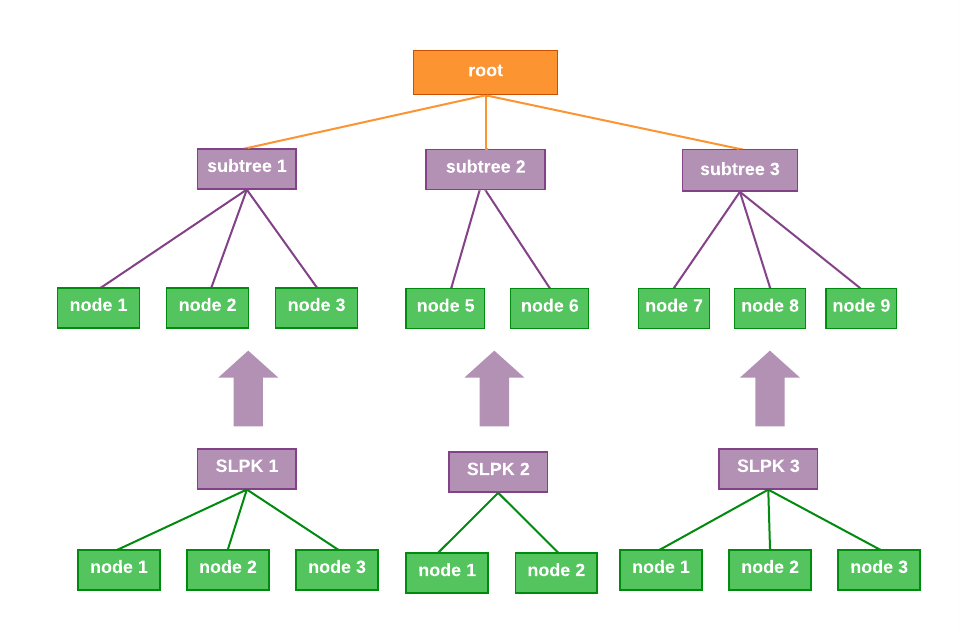
The i3s format requires an indexed structure where all nodes ordered in a bounding volume hierarchy. To append data, you can organize subtrees underneath the root node and re-index. Besides recreating the index, you would also have to consider:
- A maximum of 255 subtree of nodes can be created under a parent node
- When working with 3D objects featureIDs must be unique for the entire layer and not only for the subtree

IT.NRW uses a python script to update the hosted i3s service every time a new area of the mesh has been processed. The entire area is split into fixed sub-areas that will be surveyed following a predefined schedule.
The python script can be adapted to work for different i3s profiles like 3D objects, mesh, points, or formats like SLPK or I3SREST.
Outlook
The mesh layer will build the foundation for the emergency response digital twin and potentially other digital twins in the future. All layers will be published as open data. The state of North Rhine-Westphalia is committed to providing high quality geospatial information and making it accessible to everyone. You can view the mesh in a web scene in ArcGIS online or work with the service directly. You can also explore the digital twin of North Rhine-Westphalia.
IT.NRW continues to update the mesh layer. You can view details about the current coverage as WMS service. In addition all mesh data are available via download as SLPK.
The project shows how advantageous the close collaboration between user, geospatial integrator, and ESRI’s development teams can be to not only support a great initiative but also to learn firsthand how to best maintain large 3D layers and what capabilities are required to evolve the data management of web layers.
If you want to learn more about the disaster response digital twin and mesh processing please get in touch with Dr. Thore Fechner, team manager for open data, via Digital Twin at con terra.


Article Discussion: