Community risk reduction, which involves the identification and prioritization of risks followed by the investment of resources to reduce them, has become a standard practice in the fire service. As call volumes increase and become more diverse in nature, forward-thinking fire departments are turning to community risk reduction to maximize the impact of their mitigation efforts and better protect their communities.
Community risk reduction is best conducted at the local level; however, many state and regional fire agencies conduct risk assessments and manage programs that empower local fire agencies to conduct data-driven risk reduction activities. Examples include statewide smoke alarm installation programs, fire sprinkler education programs, seasonal risk prevention projects, and wildfire risk reduction initiatives, to name a few. The logistics of running these programs and initiatives—like managing agency involvement, tracking activities and inventories over large geographic areas, reporting outcomes to various audiences, and socializing the programs to the public—quickly become complex.
The Community Risk Reduction solution can be configured and extended to assess statewide or regional risk, manage projects with multiple agencies collecting data from the field, track statewide or regional outcomes, and share programs and initiatives with a wide variety of audiences.
Statewide community risk assessment
The process of conducting a community risk assessment involves curating and analyzing disparate datasets to identify and prioritize local risks. The use of community risk assessment at a state level is unique. The geographic area examined is broad, and the datasets are analyzed with a higher level of aggregation.
A broadened geographic lens provides an opportunity for comparative analysis, in which state fire agencies can compare like areas to one another and examine where risk outliers may exist. For example, two areas with similar demography may have different residential structure fire rates. Conducting fire prevention activities where a higher fire rate exists would mean mitigation resources are being prioritized and optimized.
The Community Risk Assessment app can be configured and extended to fit local or state geographies, regardless of the agency’s size or jurisdiction type. When extending the Community Risk Reduction solution to best fit a state or region, the Community Risk Assessment web map can be configured with various datasets that support statewide analysis. For example, state-specific risk indices, regionally specific data, and seasonal risks can be added to the map and used in the Community Risk Assessment app to inform project planning.
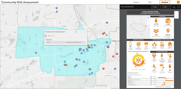
Once risk is identified and a potential project area is determined in the Community Risk Assessment app, the Analyze tab empowers state agencies to better understand who and what is in this area. Using the capabilities of the Business Analyst widget, the data displayed is defined by your project area, not by predefined geographic subdivisions like city boundaries or census tracts. This level of precision allows you to tailor your project materials, like education topics and specialty devices for older adults or disabled individuals, to best fit the citizens in the project area.

Manage programs and collaborate near and far
Many state fire agencies procure items like smoke alarms, medical oxygen fire breaks, or loaned-out education items, like fire extinguisher props, to distribute to partners and stakeholders for proper installation and education. Tracking where these items go, when they are used, and the impact they have is logistically difficult. The Community Risk Manager app can be used to track inventory, including the funding source used for procurement.
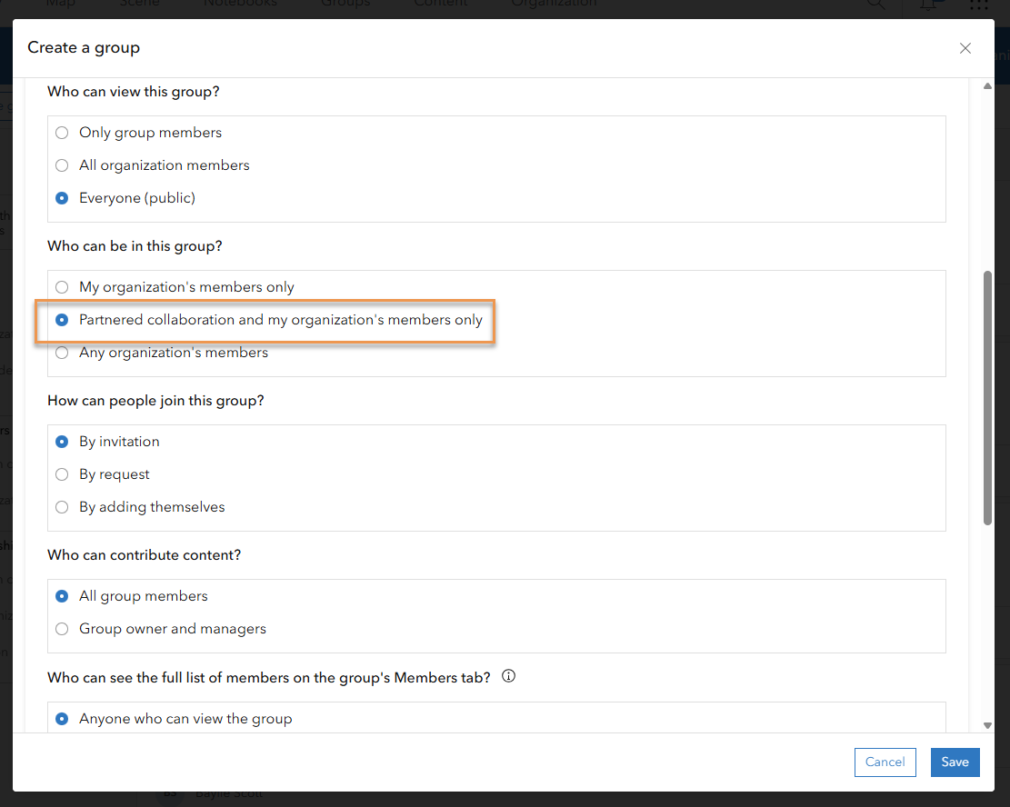
From the field, partners and stakeholders can collect real-time data as they conduct community risk reduction activities. The state agency can share the Community Risk Reduction Activity Reporter web map and the RiskReduction feature layer with partnering agencies using a partnered collaboration group in ArcGIS Online. The partnering agency can sign in to their ArcGIS Online organization, access the state agency’s Community Risk Reduction Activity Reporter web map in the group, and use ArcGIS Field Maps to collect state-project-specific data from the field. The group in ArcGIS Online allows the state fire agency to control who has access to update data while empowering local agencies to track their prevention work. Additionally, as activities are completed, home visits and events data—including the use of state-procured resources—is directly reported through the ArcGIS Field Maps workflow. For example, when a fire department partners with the state to conduct a smoke alarm installation canvass in a high-risk neighborhood, crews can log home safety visit outcomes, smoke alarm installations, and other pertinent information from the field on their mobile phone or tablet using ArcGIS Field Maps. This provides the state with near real-time outcomes from the event and removes traditional pen-and-paper documentation for firefighters.

Share programs and track outcomes
State agencies have the unique challenge and opportunity of broadcasting community risk reduction initiatives to two distinct audiences: Partnering agencies and the general public. The Community Risk Reduction hub can be configured to do both. Using the Community Risk Reduction hub site that deploys with the solution, state fire agencies can update the site with state-specific risk reduction messages, post about events happening across the state, and share public-facing data. Additionally, the solution can be extended to share program-specific information with stakeholders. A second page can be added to the Community Risk Reduction hub site app to host administrative program information, like how to request engineering technologies or props and important program announcements and instructions. The page can be shared to a group in ArcGIS Online, making it only visible to fire departments participating in statewide initiatives.
The Community Risk Reduction solution also includes the Community Risk Reduction Outcomes dashboard that helps agencies visualize program metrics. This dashboard can be shared internally, with other state entities, and with partnering local agencies.
Visualize data at different geographies
For state fire agencies, the type of visualization and analysis is highly dependent on the audience. When reporting data locally, data is often summarized by county or city boundary or by fire department or fire station first due areas. Reporting data at the state level can require a more cross-cutting approach. Risk assessments may benefit from federally defined geographies, like economic development districts, opportunity zones, or Census Bureau subdivisions. Many internal state reports require that data be summarized by legislative zones, counties, or state-defined geographic subdivisions.
To account for the multiple levels of geography needed to conduct statewide community risk reduction, the solution can be extended to use multiple geography levels across the solution’s maps and apps. For example, legislative districts can be added to the Community Risk Assessment map to help state fire agencies assess risk by congressional or Senate district. Additionally, the Community Risk Reduction Outcomes dashboard can be configured to provide a quick summary of the activities, events, and outcomes by legislative district.
In summary, the Community Risk Reduction solution is a versatile tool that can aid state and regional fire agencies in running data-driven, comprehensive risk reduction analysis and programs. This solution allows for the effective management of projects across multiple agencies, the precise tracking of inventories and outcomes, and the broad sharing of risk reduction initiatives with various audiences. The Community Risk Reduction solution enhances the ability of fire agencies to best protect communities, regardless of their jurisdictional size or scope.
Learn more
For more information about the Community Risk Reduction solution, explore the following resources:
- Learn how to deploy, configure, and use the solution.
- Watch the demo video.
- Watch a video about using GIS, including the Community Risk Reduction solution, for state fire agencies.


Article Discussion: