During the coronavirus (COVID-19) pandemic, businesses, educational institutions, and government agencies must protect the health and safety of people who work, shop, study, or use their facilities. As a result, organizations are creating health safety plans for their sites and facilities that may include:
- Placement of preventative health resources such as PPE and hand sanitizer
- Risk mitigation through planning of socially distanced lines or areas where people crowd together
- Identification of high-touch surfaces in need of cleaning or sanitizing at a regular interval
- Response plans for screening locations and the isolation of potential cases
To create and manage these plans, many organizations are creating a new role inside their business, government, or university- the Health Safety Officer. While this role may have a different title, the employee performing this function must ensure that preventative efforts are maintained, mitigation policies are enforced, and that potential health issues are responded to in a timely, safe, and effective manner.
The Coronavirus Site Safety solution can be used by businesses, educational institutions, and government agencies to create coronavirus (COVID-19) health safety plans for their facilities, sites, and campuses; and monitor the health safety plans as locations reopen. The solution includes a collection of ArcGIS applications used to create a COVID-19 health safety plan (for example, temperature screening locations, handwashing or sanitizer stations, personal protective equipment (PPE) stations, isolation areas, etc.), estimate crowd capacities and monitor social distancing, track cleaning and disinfecting, monitor restocking of PPE stations, and report coronavirus-related problems and issues.
Manage Sites
Creating and implementing health and safety plans for sites, facilities, campuses, or other locations is important as schools, colleges, businesses and facilities reopen during the coronavirus (COVID-19) pandemic. Coronavirus Site Safety is a comprehensive solution to manage each of your sites, or facilities, in one central location. Each site, or facility, can progress through the site safety planning process, site planning, and operations independently so you have the flexibility to implement appropriate health safety measures.
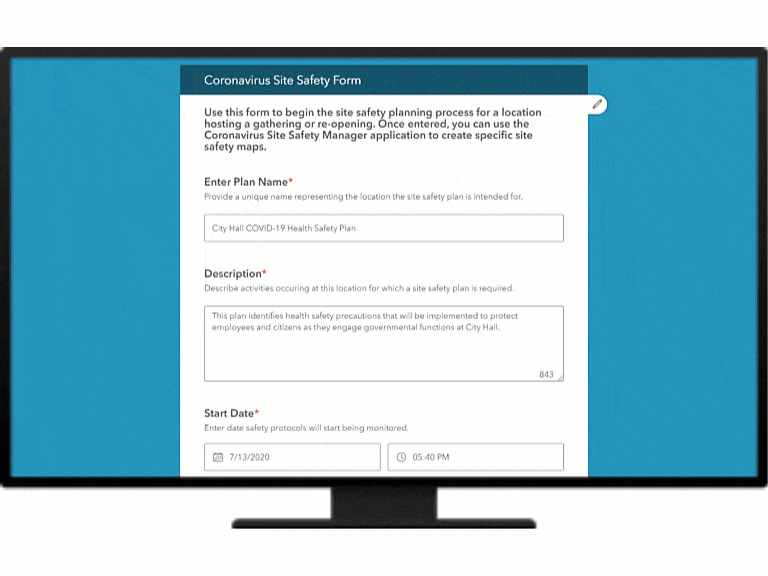
A Health Safety Officer who needs to initiate the site safety planning process can use the Coronavirus Site Safety Form to add a site where a health safety plan will be created. Enter a plan name, details about the site, define a point of contact, and even upload a written document.
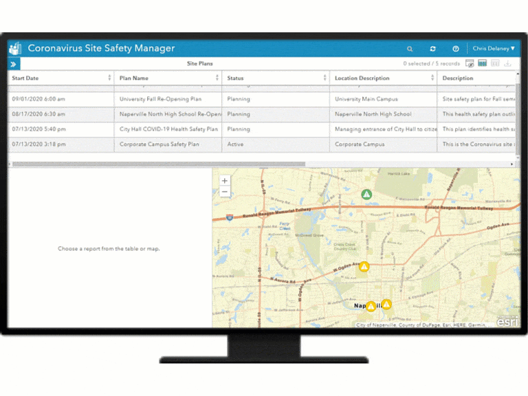
Coronavirus Site Safety Manager can be used by a Health Safety Officer to manage the status of health safety plans. Click on a plan to update the status or description of the site, or facility, and select options to create or share site safety plan maps for your location.
Prepare site safety plans
To protect the people who work, shop, study, and use their facilities, organizations are preparing comprehensive site health safety plans that include prevention, mitigation, and response capabilities. A site health safety plan, and the health safety officer who manages it, represent the front line of pandemic defense for any organization, and an essential component of a safe “back to work” strategy.
Health Safety Officers need to place preventative health resources, mitigate risk via socially distanced crowd management, identify high-touch surfaces in need of frequent cleanings, and prepare response plans for screening locations and the isolation of potential cases.
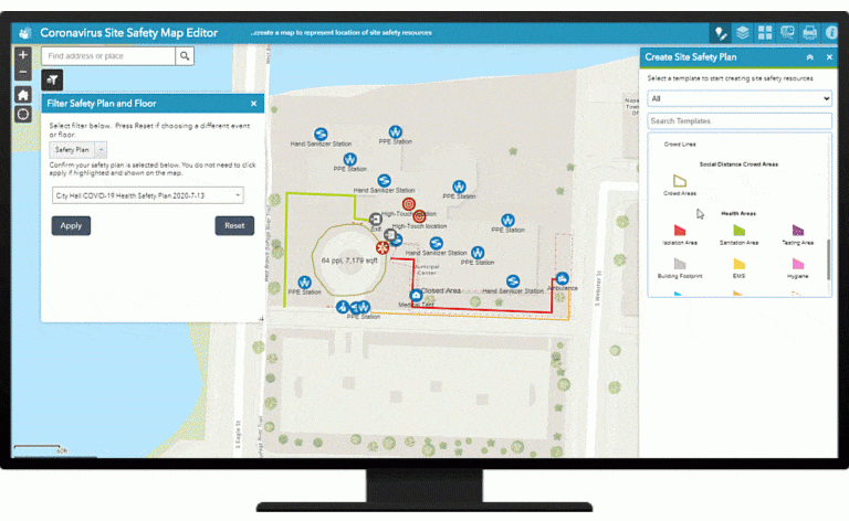
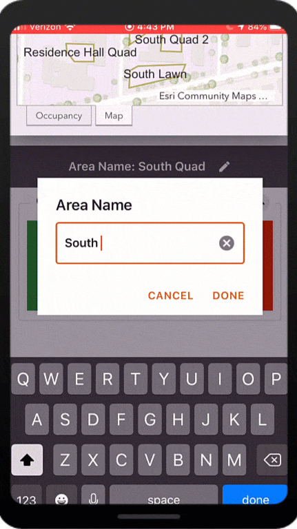
The Coronavirus Site Safety Plan Map Editor can be used to locate health resources and create social distance capacity estimates required for a health safety plan. The socially distanced capacity estimates for areas or lines are based on U.S Fire Administration guidelines.
Share site safety plans
Employees, students, customers and other people returning to a facility may be concerned about large crowds or other conditions that increase the likelihood of being exposed to the coronavirus. To ease those concerns, Health Safety Officer’s need to communicate to their stakeholders key aspects of their site health safety plans, such as the locations of entry health screenings, hand sanitizer stations, or Personal Protective Equipment (PPE) stations.
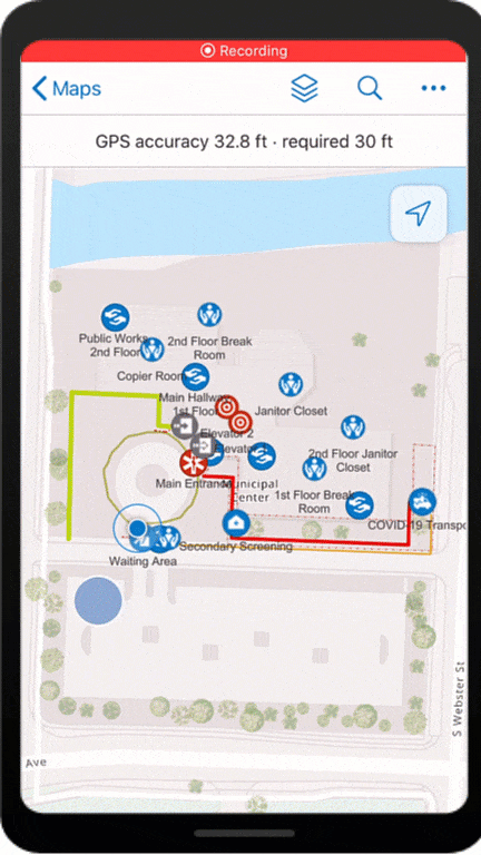
The Coronavirus Site Safety Map Viewer can be used by stakeholders to review a health safety map for a given location.
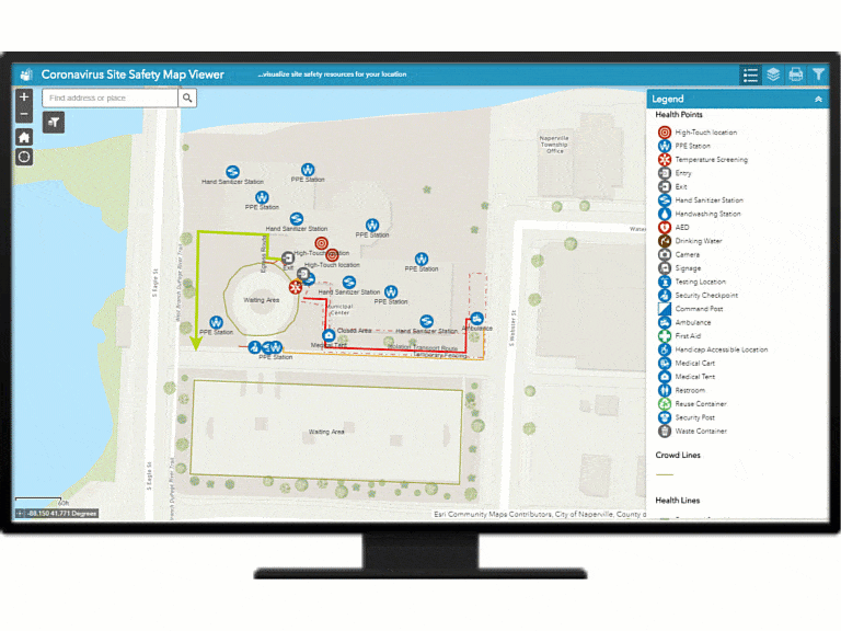
Employees, students, customers, and other key stakeholders can explore aspects of the site safety plan map, filter by items of interest, and create hardcopy maps or images for personal use.
Conduct health and safety operations
The Coronavirus Site Safety solution provides a complete set of capabilities that help Health Safety Officers, Security Officers, Janitorial Staff, and other employees collaborate to operationalize the site health safety plan in order to keep people at the facility, campus, etc. healthy and safe.
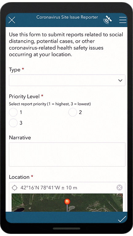
Coronavirus Site Safety Issue Reporter can be used by field staff to report social distancing concerns, potential cases, and other health safety issues. From any mobile device or browser, enter the type of issue, priority level, describe the problem and location, and, if necessary, capture an image of the issue.
The Crowd Counter App can be used by staff to count people entering and exiting an area. Large buttons make it easy to capture a real-time count of people as they enter and exit a location, and visualize an area’s current crowd count to ensure it is not exceeding maximum capacity.
Cleaning or disinfecting high-touch locations and ensuring that hand sanitizer, PPEs, and other health resources are restocked in a timely fashion is a critical component of a health safety plan. The Cleaning and Restocking Status Map can be used to manage the cleaning, disinfecting, and restocking status of health safety resources. When cleaning staff has completed a cleaning or restocking activity, they can open the map in ArcGIS Collector, select the location and update the status.
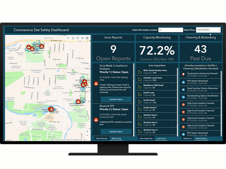
The Health Safety Officer in an organization is ultimately responsible for ensuring a health safety plan is operationalized properly and operational problems are addressed as they arise. The Coronavirus Site Safety Dashboard can used by a health safety officer to monitor health safety plan operations for a location. Select the plan you want to monitor, visualize open health safety issues and update their status, track capacity of your crowd areas, and identify locations that are overdue for routine cleaning, disinfecting or re-stocking. The Coronavirus Site Safety Dashboard can be accessed on a desktop computer or mobile device.
Additional Resources
Coronavirus Site Safety is part of larger collection of ArcGIS Solutions that will help your organization get “back to work”. The solutions help you understand the capacity of your workforce, track the status of your facilities, evaluate how cases and health restrictions may impact reopening, develop and monitor health safety plans, and conduct health screenings when a facility does reopen.
Learn more about the coronavirus solutions and how you can quickly deploy these solutions on the ArcGIS Solution site. For questions and feedback, chat with us on GeoNet or contact Esri Support Services.
Finally, Esri is providing several resources to help organizations combat the coronavirus. The COVID-19 GIS Hub is the place to access additional resources and to request GIS assistance from Esri.

Article Discussion: