Introduction
Welcome to another release of ArcGIS Production Mapping and ArcGIS Defense Mapping. The Production Mapping extension optimizes geographic information system (GIS) production to the way your organization works by ensuring consistent workflows through map production automation. It provides tools to efficiently perform database maintenance, improve quality control for data and map products, and provide managers insight into the status of the work in their organization. The Defense Mapping extension takes it one step further and streamlines GIS production for defense mapping agencies and contractors to support mission-critical applications with tools for data collection and attribution, data validation, and production of standardized defense data.
ArcGIS Production Mapping and ArcGIS Defense Mapping updates to ArcGIS Pro 2.9
This release has seen multiple new geoprocessing tools, some of which are functionalities that were previously available in ArcMap.
At ArcGIS Pro 2.9, the cross-reference geodatabase that the Load Data tool uses to map source data to target data can be created using the Create Cross-Reference Geodatabase tool.
The Generate Spot Heights tool has two new parameters that help refine the appearance of the spot heights so that they are optimized for print and display at the specified scale.
Topological errors, known as pseudo nodes, occur when the endpoint of one line touch the endpoint of only one other line. The new Merge Lines By Pseudo Node tool fixes these errors by dissolving features where pseudo nodes occur. This is particularly useful for depicting true intersections versus overpasses/underpasses.
When it comes to topographic mapping production workflows, you can create a collection of tasks known as a Task Group and base it off of the properties of an existing job using the new Create Task Group Jobs tool. It also determines what types of task group jobs and how many need to be created, once another job is completed. The new Set Task Group Dependencies tool creates dependencies between a job and other existing task group jobs based on the criteria defined in the extended properties. It determines if any task group jobs already exist in the workflow repository that should be completed before the next job begins. If a dependency exists, the next job won’t begin work until the other job(s) have reached a specific status.
New Joint Operations Graphic Product (JOG)
At the Pro 2.9 release the Defense Mapping product data files and Topographic Production geoprocessing tools further support the creation of data necessary to produce the JOG map product as follows:
- The bands that represent elevation levels on a map product can be generated using the Generate Elevation Bands From Features
- Maximum elevation figures (MEF) can be calculated using the Calculate Max Elevation Figures The resulting values are then used as labels in the MEF feature layer. You can calculate MEF values for Joint Operations Graphic (JOG), Operational Navigation Chart (ONC), Tactical Pilotage Chart (TPC) grid cells, NATO STANAG-3591 Edition 6, or any other polygon grid feature.
- The location diagram features for a Joint Operations Graphic (JOG) map sheet can be generated using the Generate Location Diagram Features
Updates to ArcGIS Production Mapping and ArcGIS Defense Mapping for Enterprise 10.9.1
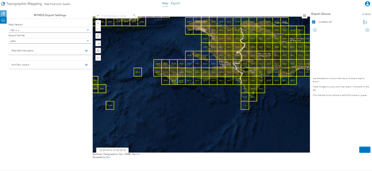
The enhancements this time around focus on the ArcGIS Enterprise Map Production System (MPS) portal app that ships with the product files installer. You will need to have ArcGIS Production Mapping Server or ArcGIS Defense Mapping Server already set up. You can use the MPS app to produce and share high-end map products. One of the steps in the app is to specify the area of interest (AOI) you’d like to export by choosing predefined boundaries from a grid and adding them to the export queue.

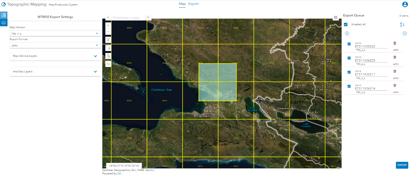
At Enterprise 10.9.1, a new custom extent tool button has been introduced that lets you specify a custom extent for the AOI. You can reposition, resize, and even rotate the AOI after it’s been created but before you add it to the export queue.

This enhanced functionality means that you’re not tied to a predefined map sheet extent, instead you can essentially create a map of anywhere. For example, if your area of interest entails more than one of the standard map sheet boundaries, you would need to add each of those predefined boundaries to the export queue. At 10.9.1, you can specify one custom extent. This reduces the number of areas you will need to export, thereby reducing the time it takes to export your queue.
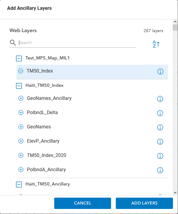
When specifying your map product export settings, you can also now choose a specific layer from a map service or feature service for the Ancillary Layers setting. This allows you to add data to your map from groups outside of your organization, as well as within your organization.

Learn More
Find out how to get started with the ArcGIS Production Mapping and ArcGIS Defense Mapping extensions for ArcGIS Pro or learn more about their geoprocessing tools by visiting the links below.
- Get started with Production Mapping
- Get started with Defense Mapping
- An overview of the Topographic Production toolbox
Watch how ArcGIS Defense Mapping software is used to standardize and streamline defense-based cartographic production tasks using ArcGIS Pro on the Esri Events YouTube channel or see how these extensions automate creation of multi-scale data and cartographic products.


Article Discussion: