
ArcGIS Pro 3.4 is here. The teams working on ArcGIS Pro have outdone themselves with this release. From enhanced data visualization and GeoAI capabilities to improved search and license management, this update brings greater efficiencies for both administrators and users. Let’s explore what’s new so you can start working with these features yourself.
In a hurry? Watch the video below for a quick overview.


Quick Links
Use the links below to jump to the release highlights that matter most to you.
- Create a definition query from a feature layer selection
- Control symbol class visibility for unique values symbology
- Limit how long licenses can be taken offline
- Share 3D tiles with ArcGIS Enterprise
- Create combo charts
- Support for foundational GeoAI models in imagery and text analysis
- Hyperspectral imagery enhancements

New Capabilities:
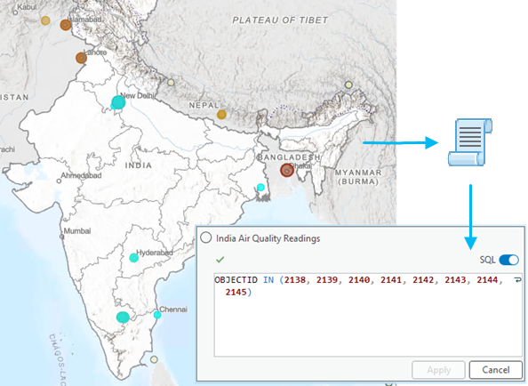
Create a Definition Query from a Feature Layer Selection
With the new Generate Definition Query From Selection tool, you can now quickly create a definition query based on selected features in a map or scene. Filter selections by field values and focus on the data that matters most without the hassle of manual filtering. This feature simplifies the process of narrowing down datasets, making analysis faster and more efficient.
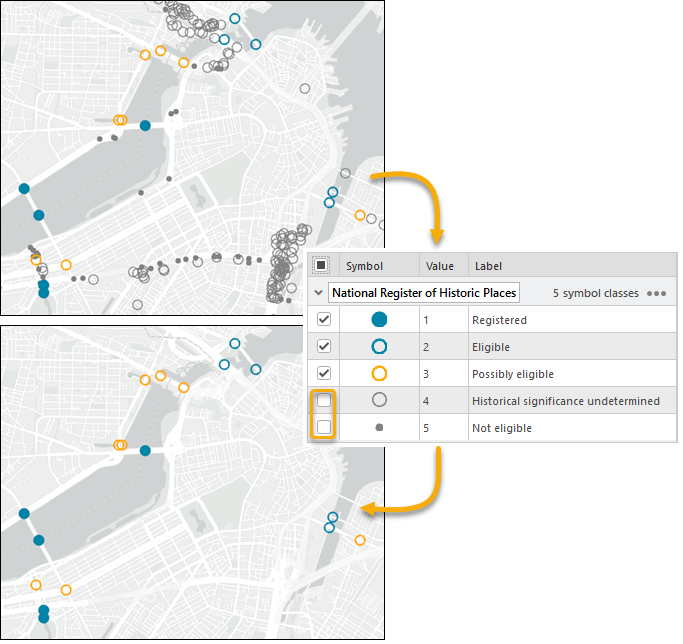
Control symbol class visibility for unique values symbology
Take control of how your data is displayed.You can now adjust the visibility of individual symbol classes with unique values symbology. From the Symbology or Contents pane, you can highlight specific data categories and trends, or hide important information across many map layers.
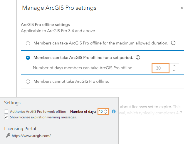
Limit How Long Licenses Can Be Taken Offline
ArcGIS Online administrators now have the ability to control how long ArcGIS Pro licenses can be taken offline. Set a time limit for license checkout, and members can choose how long to take the license offline, up to the administrator’s limit. This feature adds security and flexibility to offline license management.
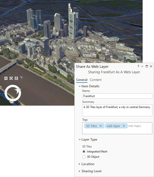
Share 3D Tiles with ArcGIS Enterprise
Publish 3D tiles datasets as web layers in ArcGIS Enterprise 11.4. Whether from a scene or a cloud-based dataset, these 3D layers provide large-scale, immersive visualizations, helping you perform more dynamic analysis and better decision-making in web scenes.
Create Combo Charts
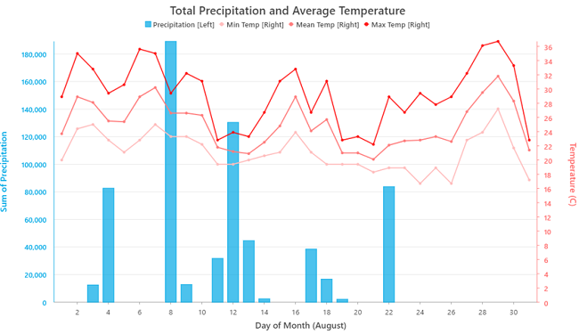
Visualize your data in a more flexible way with combo charts. Combine bar and line series in a single chart, using dual y-axes to compare datasets of different scales. This makes it easier to uncover relationships between variables and gain deeper insights from your data.
Support for Foundational GeoAI Models in Imagery and Text Analysis
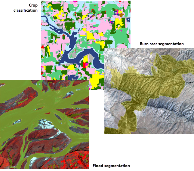
Take advantage of AI-driven workflows with new support for geospatial foundational models, like Prithvi and ClimaX. Whether you’re performing crop classification, flood segmentation, or weather forecasting, these pretrained models help you tackle complex geospatial tasks with more accuracy. You can also leverage large language models (LLMs) like Mistral AI to automate text analysis tasks with fewer computing resources, making workflows faster and more efficient. Read this blog to learn more about the new pretrained GeoAI models being used for disaster response.
Hyperspectral Imagery Enhancements
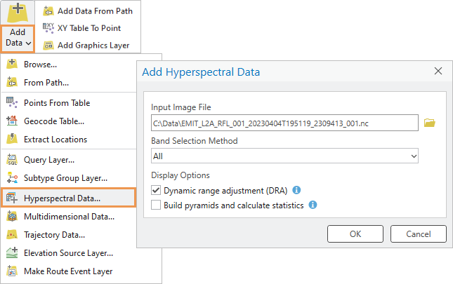
With enhanced support for sensors, ArcGIS Pro 3.4 introduces compatibility with Airborne Visible/Infrared Imaging Spectrometer (AVIRIS) hyperspectral imagery. Seamlessly work with these images, either as a single image or a collection within a mosaic dataset. Additionally, improvements to the CRF format make it easier to store and manage large hyperspectral datasets, ensuring smoother workflows when handling complex data.
Browse the help documentation to learn about all the latest new features and enhancements.

Productivity Improvements in ArcGIS Pro 3.4
- Enhanced Search Functionality
Quickly find what you need with the enhanced search. Now, you can search for properties and settings across application options, map properties, layer properties, and dialog boxes, saving you time and keeping you focused on your tasks. - Semantic Search
Go beyond exact word matching with semantic search, which understands the meaning behind your search terms, helping you to discover tools, commands, options, and settings, even when you don’t know exactly what they’re called. Available for both command and property searches, it also works in English or a local language if a language pack is installed. - Minimize Floating Views
Keep your workspace organized and clutter-free by minimizing floating views, like the Attribute table or the Catalog view. Restore them instantly by hovering over the ArcGIS Pro icon in the taskbar. - Simplified Ribbon Option
A simplified ribbon option reduces command icons to smaller sizes without text, giving you more space for your maps and other views. This change allows you to focus on the task at hand and optimize your workspace. - Export Keyboard Shortcuts to PDF
You can now export your customized keyboard shortcuts from the Keyboard Shortcuts dialog box as a PDF. Print this out as a cheat sheet and stick it to your monitor or next to your keyboard to reduce mouse travel and clicks. - More Control Over Update Notifications
Administrators can now configure update notifications to get patch updates even when your organization is not on the latest ArcGIS Pro release, ensuring that your users have the latest quality improvements. - Shared Add-ins
Add-ins stored in a well-known folder on a network drive now appear as shared add-ins. This prevents accidental deletion, ensuring that important tools remain available to all users within an organization. - Silent Installation Command Line Parameters
Managing large deployments is now easier with the new silent installation command line parameters. These allow for silent installation of ArcGIS Coordinate Systems Data and the deauthorization of Single Use licenses, streamlining software management for larger teams. - Stacked Panes with Icons
Stacked panes now feature icons, making it easier to recognize which pane you need without having to hover over or click each tab. Use the drop-down arrow to open a pop-up with the full name of each pane. Try the new Close Others and Close Tab Group from a pane tab’s right-click context menu to quickly organize your panes.
Browse the help documentation to access more detailed information on performance and productivity improvements just released.

Expanding Core ArcGIS Pro Capabilities
ArcGIS Pro 3.4 introduces significant updates to its extensions, offering greater potential for specialized workflows. Whether you’re managing complex imagery or improving aviation workflows, explore the latest release blogs for these enhancements:
- ArcGIS Image Analyst Extension — In the latest version of ArcGIS Pro, users continue to gain expanded access to image management and analysis capabilities through user types. With this update, you get more oriented imagery functionality, new GeoAI tools that help find changes in SAR images, model training for object detection, and support for video metadata. Read the blog to learn more.
- ArcGIS Data Reviewer Extension — This release of ArcGIS Data Reviewer has enhanced data quality workflows in ArcGIS Pro. These include an automated error detection feature, improved usability for existing data quality checks, and updated workflows based on expert feedback. Read the blog to learn more.
- ArcGIS Indoors — This release of ArcGIS Indoors Pro introduces point cloud-to-floorplan creation, an efficient alternative to building indoor maps without CAD or BIM data. Also, explore new tools and enhancements to create routable networks, as well as new capabilities to existing workflows that simplify them and boost productivity. Read the blog to learn more.
- ArcGIS IPS — This release introduces enhancements to ArcGIS IPS configurations in ArcGIS Pro, support for offline workflows and 3D visualization, and more. Read the blog to learn more.
- ArcGIS Aviation — The latest release offers increased functionality and support for aviation tools for airport management, chart production, data handling, and design workflows. Read the blog to learn more.

Upcoming Live Events
Webinars designed to keep you growing that GIS skill set. Don’t miss out on these exciting opportunities to expand your expertise with ArcGIS Pro and connect with fellow professionals. Check out the following upcoming events and register today:
- Migrating to Utility Network with Data Reviewer Quality Checks — Join this upcoming webinar to learn how to make sure your water utilities have accurate and reliable data. You will also learn about the benefits of moving to the ArcGIS Utility Network. Go here to register.
- From Surface to Seafloor: ArcGIS Bathymetry’s Advancements in 2024 — Join us to learn about the newest features and capabilities of ArcGIS Bathymetry, the tool for creating custom bathymetric surfaces and performing on-the-fly data extraction. Go here to register.
- Python 101 for ArcGIS — Join this no-cost live training seminar at Esri Academy. Experts will explain code building blocks common to many programming languages, then show how to add logic and assemble everything into a reusable Python script that automates an ArcGIS workflow. Go here to register.
- Want more Python in your life? The updated Python Scripting for ArcGIS Pro and Advanced Python Scripting for ArcGIS Pro books are now available. Use promo code Python30 for 30% off—valid until December 15 for US and Canada only.

Stay Connected
So much to explore in this release, but the fun and learning doesn’t have to end here—and you don’t have to wait until the next big release in 2025. Make sure to follow our ArcGIS Pro X (formerly Twitter) page and join our LinkedIn group to stay updated with the latest tips and resources. Don’t forget to subscribe to the ArcGIS Pro newsletter for expert insights and updates—next edition coming in November.


Commenting is no longer enabled for this article