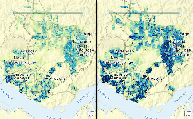
We are pleased to announce the first two 100-m resolution gridded population layers from WorldPop are now available in the Living Atlas of the World. These multidimensional layers have global coverage and contain annual estimates for total population and population density for the years 2000 through 2020.
In December 2021 we announced the partnership between Esri and WorldPop and WorldPop’s 1-km gridded population data availability in the Living Atlas. Currently two of the three planned layers of WorldPop 100-m resolution gridded population are available:

These layers also provide an upgrade and replace Esri’s World Population Estimate (WPE) layers, which will be retired and removed from service in December 2022. The WorldPop 100-m gridded population layers represent an upgrade to the WPE layers in several ways:
- The WPE layers are coarser resolutions (300-m in 2013, and 150-m in 2015 and 2016) than the new WorldPop layers. In generally the 100-m cell size of the WorldPop allows population estimates to be derived for very specific polygons, such as drive-time areas, block-by-block event management in urban areas, and natural- or human-produced hazard footprints.
- The WPE layers represent 2013, 2015, and 2016, while the WorldPop layers represent estimates from the years from 2000 through 2020.
- The WorldPop layers use floating point values to represent population and density, while the WPE layers used integer values for population. This difference allows the WorldPop layers to be used to produce a footprint of settlement that is similar to the WPE Settlement score. The WorldPop layers have values of 0.0 (zero) where the model indicates no population. The smaller values, 0.000001 through 0.99 may represent locations where the confidence of settlement is lower and thus, alternate footprints of settlement can be derived by reclassifying the smallest values to 0.0.
- The REST URL for the WorldPop layers is open, rather than restricted to ArcGIS subscribers.
To learn more about using these layers, we have been publishing a series of posts under the title: A First Glimpse into the Future of Population Data
Here is a list of links for WPE layers and their replacements:
- World Population Density Estimate 2016 – WorldPop Population Density 2000-2020 100m
- World Population Estimate 2016 – WorldPop Total Population 2000-2020 100m
- World Population Estimate Confidence 2016 – A new layer will not be provided.
- World Population Estimate Sources – A new layer will not be provided.
- World Population Estimate 2016 Sources – A new layer will not be provided.
- World Settlement Score 2016 – A new layer will not be provided.
- World Population Estimated 2015 – WorldPop Total Population 2000-2020 100m
- World Population Estimated Density 2015 – WorldPop Population Density 2000-2020 100m
- World Population Estimate (2013) – WorldPop Total Population 2000-2020 100m
We will also be retiring all webmaps, storymaps, and derivative layers based on the World Population Estimate layers
These WorldPop 100-m layers are based on the method documented in Stevens, F. R., Gaughan, A. E., Linard, C., & Tatem, A. J. (2015). Disaggregating census data for population mapping using random forests with remotely-sensed and ancillary data. PloS one, 10(2), e0107042
Finally, all of the WorldPop layers in the Living Atlas will be updated annually with the most recent annual estimate.

Article Discussion: