Approximate Reading time: 6 minutes
ArcGIS Pro has a comprehensive suite of tools with over 2,000 geoprocessing tools in 40 toolboxes. Choosing the right tools for any analysis or data processing task is easier when you have a good understanding of what’s available. But no one can be an expert in all tools.
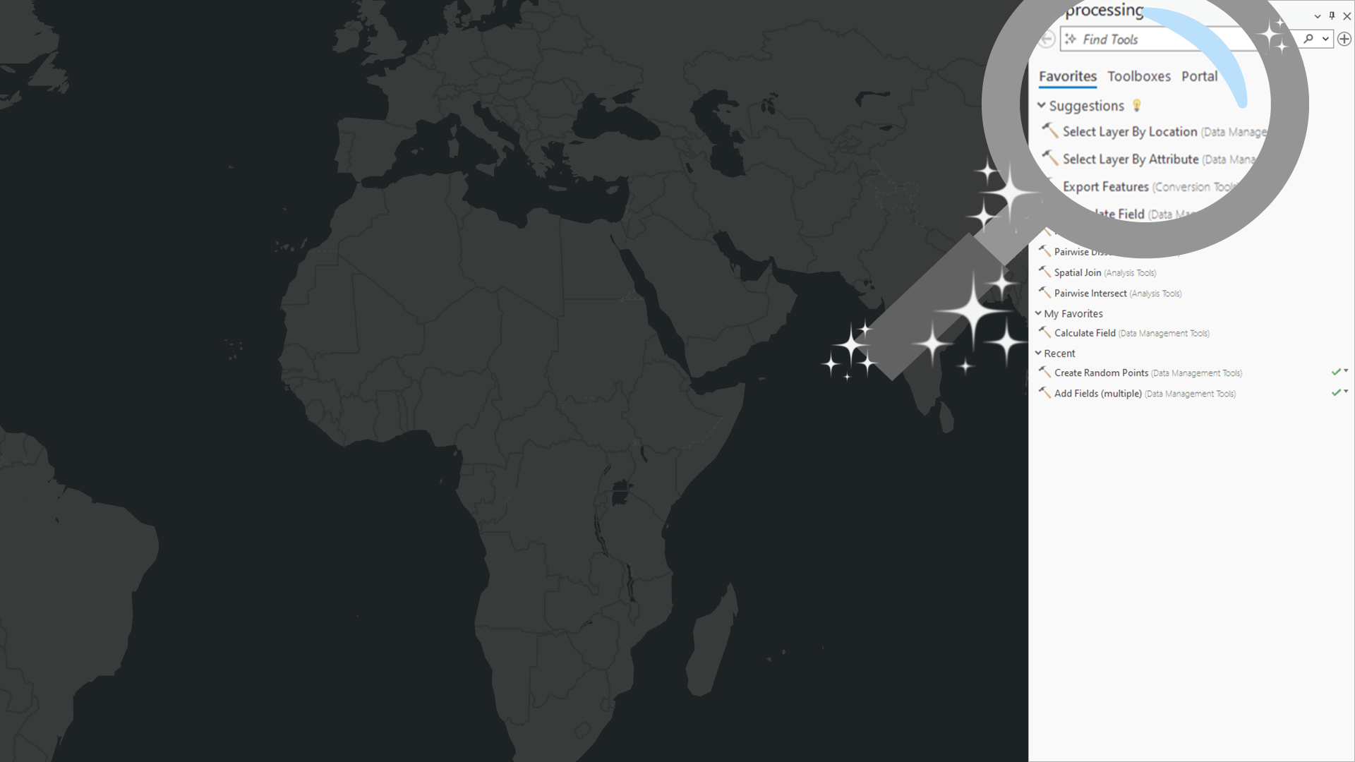
That’s why in ArcGIS Pro 3.3, we are excited to introduce new AI-enhanced experiences to help you find the right tools to perform your geoprocessing workflows. The tool search is now smarter with a semantic search engine, and you will receive tool suggestions after you run a geoprocessing tool that can help you get to the next step and complete your workflow.
Keep reading to learn more about these new features and how to get started with them in ArcGIS Pro 3.3!
Installing the AI Models
AI technology has the potential to make GIS analysts and others more efficient when using ArcGIS Pro. But we understand that some users and organizations may feel hesitant about this technology. So, in ArcGIS Pro 3.3, these new features are only available to those who opt in during installation.
You can choose to install these features on the Select Features page of the ArcGIS Pro Setup dialog by clicking on the drop-down next to each AI Model.

The models are installed locally on your system with ArcGIS Pro, so there is no communication with an external service or transformation of data related to tool search or suggestions through a network. The functionality requires no internet connection, only installation.
Note: If you’ve already installed Pro 3.3, and missed the AI features, don’t worry, you can still install them! In the Windows Control Panel, select Uninstall a program, then select ArcGIS Pro from the list of applications, and click Change. You’ll get the ArcGIS Pro installation dialog with the option to Modify the install and enable the desired AI models.
Semantic Search
Semantic search is a smart search engine technology that can recognize the intent or meaning behind a query. Standard search engines simply find partial or complete matches between a search query and a body of text being searched. A semantic search engine supports searches using conversational or natural language and understands connections between related words with similar meaning.
For example, on the Geoprocessing pane’s search bar enter: Combine the tables of two inputs.
You will receive relevant results such as Join field, Merge or Append.

Semantic search is a foundation of AI technology and works by transforming text into a meaning vector (or embedding). A meaning vector is a numeric representation that describes the text using the many dimensions or aspects of semantic meaning in language. The semantic search engine compares your search query to a database of meaning vectors to find the tools that most closely match your search.

The first time you start ArcGIS Pro 3.3, it will take a few minutes to build the embeddings database for all geoprocessing tools. But don’t worry, this happens in a background thread so you can still perform other tasks, including searching for geoprocessing tools using the standard search engine.
When the semantic search engine is ready to use, the icon  in the search bar will enable.
Note: Semantic search is not an AI Chat bot or assistant. It cannot provide workflow steps or answer general questions; rather it will return search results with the tools most closely related to your query.
Tool Suggestions
Have you ever started an analysis, then asked yourself, “which tool could I use next”? Or maybe you know the next tool to use, but wish you could get to it in fewer clicks. New in ArcGIS Pro 3.3, geoprocessing tool suggestions are provided after each tool you run to help you get to the next step and complete your analysis. You can find tool suggestions on the tool status banner and Geoprocessing pane Favorites tab.

To provide tool suggestions, the ArcGIS Pro development team created a sequence prediction model for geoprocessing tools. The model is trained using hundreds of thousands of tool usage logs from ArcGIS Pro users that participate in the End User Experience Improvement (EUEI) program. The model suggests tools that are often used after the tools you’ve already run in your project, which are logged in your geoprocessing history. Suggestions automatically update every time you run a tool.
If none of the suggestions are relevant, you can click Try Again  to generate alternative suggestions.
Note: When you click a suggestion on the tool status banner, the tool will open in a new tool tab. You can switch between multiple open tools using the Add button ⊕ in the upper right corner of the Geoprocessing pane.
Example – Delineate a watershed using Tool Suggestions
A watershed is an area of land where water flows into a common stream or river. You can delineate a watershed from a digital elevation model (DEM) using a series of tools in the Hydrology toolset. You will find that after running the tool in each step, the tool in the next step will be offered as a suggestion for you to use next.
- Use the Fill tool to remove any sinks in the DEM.
- Use the Flow Direction tool to calculate the direction water flows across land.
- Use the Flow Accumulation tool to calculate the number cells that drain into another cell.
- Use the Snap Pour Point tool to create a pour point and snap it to the nearest cell with a high flow accumulation value.
- Use the Watershed tool to delineate the watershed.

By following the tool suggestions, you can complete this workflow in less time!

Summary
ArcGIS Pro 3.3 includes AI-enhanced user experiences to help you find and run the right geoprocessing tools for your job. The improved semantic search engine gives better results that match the meaning of what you search using conversational or natural language. And when you run a tool, you will get suggestions for the next tool you might want to use to streamline your geoprocessing workflows.
We hope you’ll install these new features, and benefit from the power of AI technology to make your use of ArcGIS Pro more productive than ever.
For further information, please visit the ArcGIS Pro page or the What’s New documentation and post your questions in the ArcGIS Pro board in Esri Community.
Bonus: What’s next for AI Technology in ArcGIS Pro?
The ArcGIS Pro development team is working on many other areas that incorporate AI technology. These may include but are not limited to the following:
- Enabling the semantic search engine for Command Search.
- An assistant to help you explore the ArcGIS Pro documentation through natural language questions.
- Coding assistants to aid in writing SQL and openCypher queries, Arcade expressions, and Python code.
- An assistant to help you plan workflows and run ArcGIS Pro functions using natural language prompts.


This is great but how can i “Install the ArcGIS Pro AI Assistant 3.4 (Beta)”? I want to use the AI assistant in ArcGIS Pro to crate complex SQL queries from natural language