The world’s largest GIS meet-up—Esri User Conference (July 10-14)—is almost here and we are excited to connect with you in person and virtually! To help you navigate the multitude of activities, we’ve prepared a focused agenda for ArcGIS Roads and Highways.
Join Us At The Expo
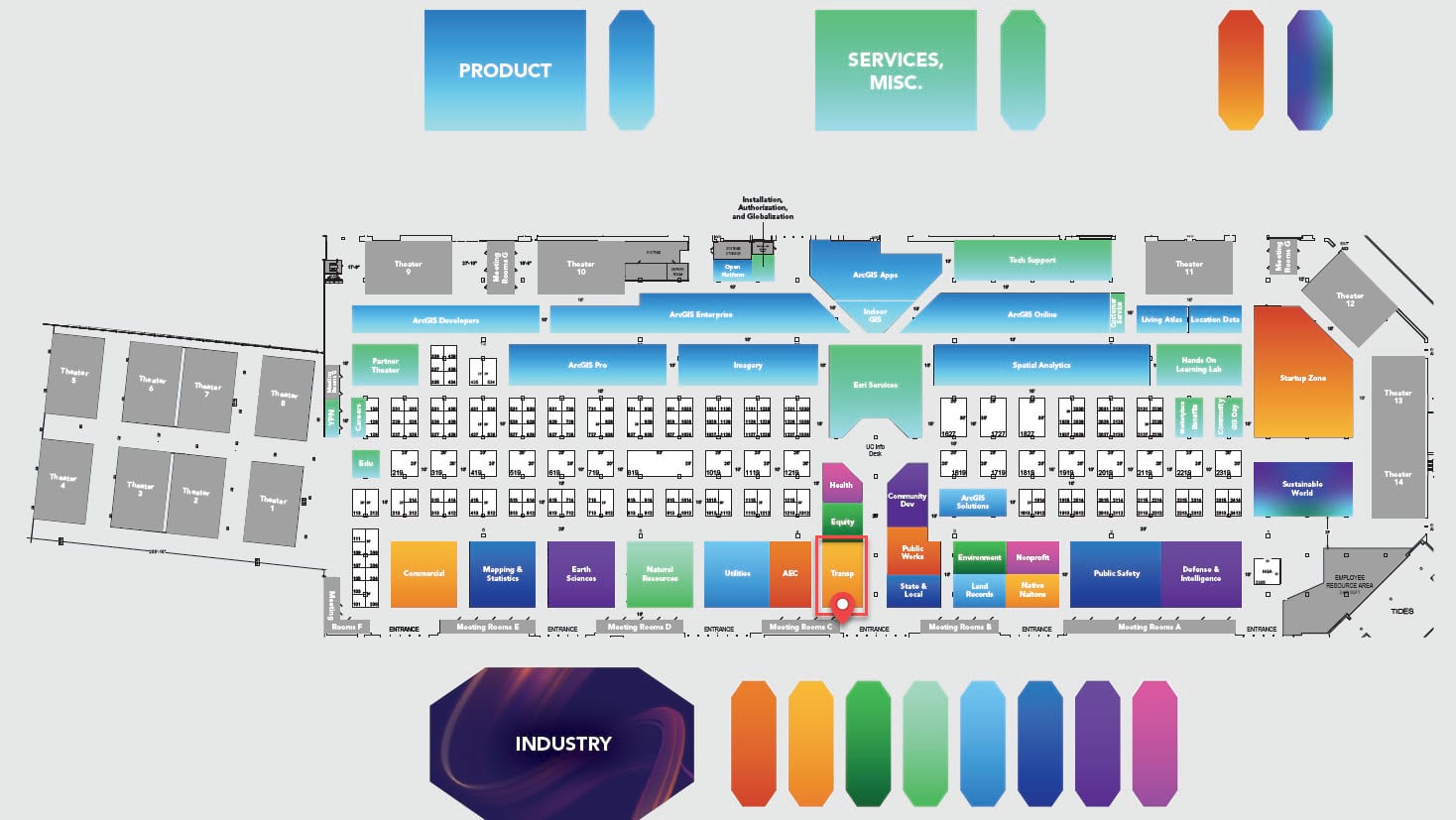
ArcGIS Roads and Highways product experts will be in the Transportation showcase area (indicated using a red box and location pin in the below image). Stop by to chat, ask your questions, and view demos of the latest features and enhancements. The showcase is located on the ground level in Exhibit Hall B and is open during these times.
- Tuesday, July 11th 9 AM—6 PM (Pacific Time)
- Wednesday, July 12th 9 AM—6 PM (Pacific Time)
- Thursday, July 13th 9 AM—4 PM (Pacific Time)
Note that the UC Event Map is now available to allow you to get familiar with the convention center and view locations of sessions and activities before you go to San Diego. You can also generate a route and directions between two locations and view the estimated travel time. Use this map along with the Detailed Agenda and My Schedule for planning your UC experience. The map will also be available in the Esri Events App and at directory kiosks on site in the convention center. Learn more.

Attend Sessions
Below is a list of sessions in chronological order.
Roads and Highways SIG: Digital Delivery for Transportation Projects
Special Interest Group | Tuesday, July 11 | 11.30 AM | Room 24 A | In-person
Departments of Transportation and other highway agencies are attempting to integrate their workflows and information processes as they move from design through the construction stage of the infrastructure lifecycle. This panel will assemble three best practice examples from Caltrans, Pennsylvania, and Montana Departments of Transportation to present their current initiatives, and to engage in a panel discussion. Learn how Esri technology can be used to integrate the full infrastructure lifecycle of a project.
ArcGIS Roads and Highways: An Introduction
Technical Workshop | Tuesday, July 11 | 4.00 PM | Room 15 B | Live-streamed, In-person, Recorded
Learn how ArcGIS Roads and Highways can be used to manage and edit roadway network centerline data, roadway characteristics, and asset data on a spatial linear referencing system (LRS). This session will provide a product overview with demonstrations of supported roadway data editing workflows, linear referenced event behaviors, geoprocessing tools to support data transformation and analysis, a REST API to extend LRS capabilities across the enterprise, and event editing in both ArcGIS Pro and in the web with the Event Editor.
ArcGIS Roads and Highways: What’s New and the Road Ahead
Technical Workshop | Wednesday, July 12 | 10.00 AM | Room 1 AB | In-person, Recorded
In this session, we will demonstrate the new features and capabilities in the latest release of ArcGIS Roads and Highways for ArcGIS Pro and ArcGIS Enterprise. Additionally, we will offer a sneak peek at what’s coming in future releases.
ArcGIS Roads and Highways for Road Management
User Presentation | Wednesday, July 12 | 1.00 PM | Grand Ballroom 4 | In-person
DOTs are responsible for the management of their roadways for maintenance, safety, and mobility. These presentations highlight best practice with regard to management of the data, which is essential for effective roadway management.
Using the Sync Service to Support Offline Data Collection in Linear Referencing Systems
Demo Theater | Thursday, July 13 | 1.00 PM | Expo Demo Theater 4 | In-person
Learn how ArcGIS Roads and Highways and ArcGIS Pipeline Referencing now supports the sync capability on linear referencing enabled feature services. With this capability, users can now make offline edits to their event data using ArcGIS Field Maps and then sync it back to the LRS to sync with any route edits made while offline.
Resources
Here are a few additional resources to learn more about ArcGIS Roads and Highways.
See you in San Diego!

Article Discussion: