The latest release of ArcGIS Earth, version 2.4, offers a suite of new features designed to enhance situational awareness and optimize workflows. Users can now visualize and interact with real-time data sourced from ArcGIS GeoEvent Server or ArcGIS Velocity. Additionally, the update provides seamless offline support for ArcGIS Survey123, enabling survey collection and editing without internet connectivity. The release also includes support for KML Track and Multi-Track as well as 3D basemap and grid functionalities, delivering more detailed and immersive visualizations. Check out the blog for more details.
ArcGIS Earth for Desktop
Enhancing Situational Awareness with Real-Time Data in ArcGIS Earth
With this release, you can now visualize and interact with real-time data by connecting to stream service feeds from ArcGIS GeoEvent Server or ArcGIS Velocity. These servers provide low latency, real-time data dissemination from IoT platforms, message brokers, or third-party APIs. ArcGIS Earth enables seamless connection, visualization, and capture of dynamic entity observations in real-time, allowing for faster responses to critical events and more informed decisions across industries like public safety, transportation, defense, and environmental monitoring.
- Easily Find and Connect to Stream Services: Users often struggle to distinguish between feature services and stream services. To address this, we have introduced a new feature in ArcGIS Earth that simplifies the discovery of available stream services. By adding the stream service data type to the data filter options, we make it easier for you to quickly find and connect to the appropriate stream services, ensuring hassle-free access to the real-time data you need.
- Manage Dynamic Entity Observation Parameters: Managing dynamic entity observations can be overwhelming. ArcGIS Earth simplifies this process by allowing you to easily add and filter stream service types from ArcGIS Online or authenticated stream services after signing in. You can interactively snapshot or drag a spatial filter to include only the streaming data that matters most to you within your area of interest. Additionally, setting purge options optimizes the local cache, ensuring a smoother and faster experience.
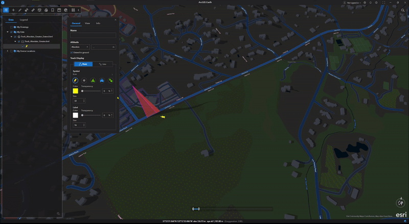
- Capture and Symbolize Dynamic Entity Observations and Track Lines: ArcGIS Earth supports various layer properties, including visibility, symbology, elevation mode, and labels. Users can display past observations and tracks of moving features like vehicles using distinct symbology to differentiate current observations from previous ones. This functionality allows users to effectively capture and symbolize dynamic entity observations, providing a clear and comprehensive view of real-time data. By visualizing the movement and changes of entities over time, users can make informed decisions and respond efficiently to dynamic situations.
- Interact with Dynamic Entities: Engaging with dynamic entities in ArcGIS Earth is now more intuitive. You can effortlessly identify and track these entities within your scene while accessing pop-up information that transitions seamlessly between dynamic entities and static observations. This powerful feature enhances your ability to monitor and analyze real-time data, providing a richer understanding of the current situation. By enabling users to interact with and follow dynamic entities, ArcGIS Earth ensures that crucial information is always readily available, paving the way for more proactive and informed decision-making.
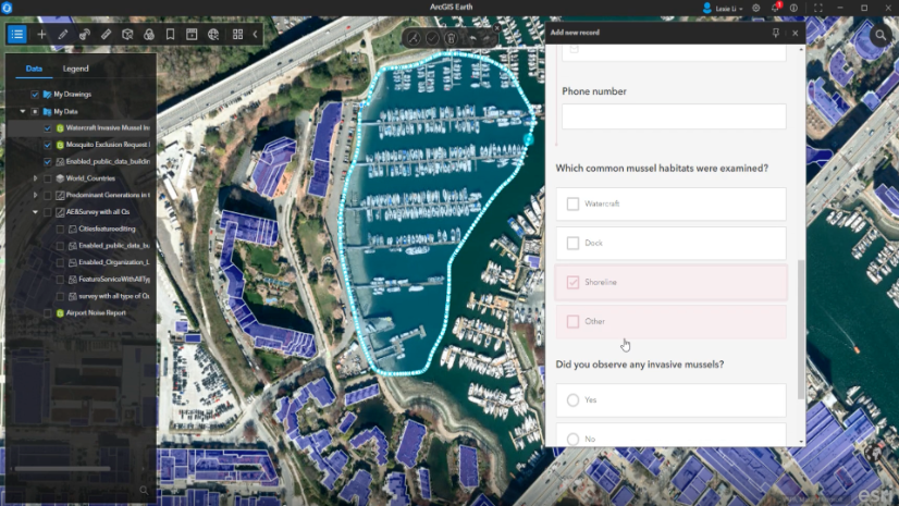
Work with Survey123 Forms Offline
ArcGIS Earth is on an exciting journey of innovation, prioritizing network resiliency and offering seamless offline workflows. The latest breakthrough is the offline support for ArcGIS Survey123, empowering mobile workers to load and edit surveys without needing internet connectivity. This fantastic feature brings tremendous advantages to mobile workers using laptops, ensuring smooth and efficient data collection in any environment.
- Seamless Offline Functionality: Users can confidently carry on with their data collection tasks without any interruptions, ensuring that no crucial information is lost due to connectivity problems. This seamless offline capability significantly boosts the efficiency and reliability of field data collection, allowing for the accurate gathering of data in any setting.
- Configurable Service Address: The new capability allows users to configure the Survey123 service address using the config.json file. This flexibility means that users can tailor the setup to their specific needs and environments. This configurability ensures that the Survey123 integration with ArcGIS Earth is adaptable to various scenarios, providing a customized and efficient user experience.
- Enhanced Data Integrity: By enabling offline capabilities, the risk of data loss due to connectivity issues is significantly reduced. Users can collect and store data locally, which can then be synchronized once a connection is re-established. This feature ensures that all collected data is preserved and accurately recorded, maintaining the integrity of the information. Enhanced data integrity is crucial for making informed decisions based on reliable data, and this new capability in ArcGIS Earth ensures that users can trust the data they collect.
For more detailed information, refer to Configuring ArcGIS Earth for ArcGIS Survey123 Integration.
KML Track and Multi-Track Simplify Route Tracking and Visualization
ArcGIS Earth now supports KML Track and KML Multi-Track, enhancing geographic data management and visualization. KML Track allows you to manage a single path or route, which can be easily edited, styled, and animated. For example, GPS data from a single hike can be imported for detailed analysis. This feature is ideal for tracking movements, analyzing routes, and creating dynamic visualizations.
KML multi-track groups multiple tracks, such as different hiking trails or flight routes, within a single KML file. This simplifies organization, enhances time-based visualization, and improves data management. Additional features include extended data charting in the Elevation Profile panel, smoother time animations, and support for real-time GNSS layers and historical GPS files (.nmea, .gpx). These enhancements make ArcGIS Earth a versatile tool for applications ranging from emergency response to sports event analysis and supply chain logistics.
Cross-Platform Highlights
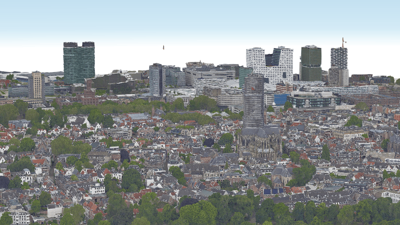
Detailed 3D Basemap with Building Representations
ArcGIS Earth now supports 3D basemaps on desktop and mobile, making it easier for our users to access immersive 3D content. This initial release of 3D basemaps will focus on 3D buildings, providing users with a detailed and realistic representation of urban environments. By leveraging high-quality data from OSM Daylight Distribution, ArcGIS Earth enhances its mapping capabilities to offer an unparalleled experience. Future updates will expand this support to include 3D trees and labels, further enriching the visual detail and utility of our maps.

Boost 3D Scene Accuracy with Grids
ArcGIS Earth now enables the display and customization of grids, providing a framework for visualizing and understanding spatial data. Users can easily visualize spatial reference systems or partition map frames by selecting from four supported grid types in scene properties. Grids ensures that 3D scenes are accurate, consistent, and suitable for the specific project needs. The supported grids include Geographic-Geographic coordinate system grid, UTM-Universal Transverse Mercator zones, MGRS-Military Grid Reference System, and USNG-United States National Grid.
Customize the appearance of a grid and associated elements in a 3D scene to improve visual clarity. For example, increase the size of label text or the width of lines to make them more visible. This helps users easily interpret spatial relationships and geographic context.

Closing Comments
We hope you find the latest updates to ArcGIS Earth useful and enjoyable. Your feedback and real-world use cases are vital for our improvements. Please share your thoughts and experiences. Join the Esri Community at the ArcGIS Earth Esri Community Page to connect with other users and our product team. Your support is greatly appreciated, and we look forward to seeing how these enhancements benefit your work.


Article Discussion: