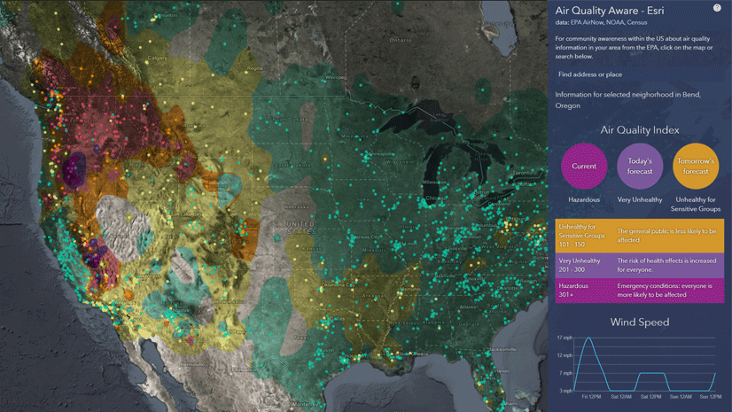
Dan Pisut
Connect:

Dan leads development of ArcGIS Living Atlas of the World environmental content, which includes information about Earth's land, ocean, atmosphere, and ecosystems. Prior to Esri, Dan worked at NOAA for two decades, leading data visualization efforts for research, communications, and education.

Posts by this author
Top 5 Tips for Styling Published Layers and Maps

The Living Atlas team publishes a lot of web layers. Here's some of our favorite tips and tricks for customizing your layers and maps.

Continue Reading

Top 5 Tips to Improve Your Feature Layer Performance

Some simple tweaks to your data prep, publishing, and ArcGIS Online configuration can vastly improve your layer's draw and query speed.

Continue Reading

A New Climate Atlas for the United States

Maps from the National Climate Assessment Interactive Atlas provide insight into the latest assessment of climate change in the U.S.

Continue Reading

Map in a Minute: Tornado Outbreaks Using Living Atlas

Quickly create a web map showing any tornado outbreak from 1950-2020 with data from NOAA in ArcGIS Living Atlas of the World.

Continue Reading

Give the REST a Rest

Using web GIS layers makes life way easier, but you're missing out if you still use the REST endpoint URL.

Continue Reading

USA Storm Reports Live Feed: Now Even Stormier!

Several upgrades to the USA Storm Reports from the National Weather Service provide more storm types, better symbology, and greater ease of use.

Continue Reading

Track U.S. Drought Conditions with Drought Aware

A new application from Esri leverages data from NOAA, USDA, and Census to visualize drought impacts in the U.S.

Continue Reading

Mapping Drought Trends in the U.S.

Are droughts becoming more frequent where you live? Let's find out.

Continue Reading

Land Cover Map Makeover in 3 Easy Steps

Take your classified land cover map from a 6 to a 10 with just a few easy steps using blend modes.

Continue Reading

1 2 3 5