Introduction
Everyone is talking about digital twins. Esri too. There are different variants of it. One thing is certain, if you want to build a digital twin of a city, you cannot do it without GIS. The ArcGIS Geospatial Platform makes it possible to collect and link all existing data and supplement it with real-time data.
Esri is putting together a demo of the digital twin of Zurich. The data was kindly provided by various organizations in Zurich. Once the data is available, this should show how to get started with simple means by quickly achieving good initial results and working towards a holistic, fully functional twin.
Would you like to join us on our journey? Let’s get started…
Start simple
There are countless conceivable use cases for a digital twin. It always depends on the problem you want to solve. However, you cannot develop a holistic urban twin all at once, so it is advisable to identify a real business case that is important for everyone involved. In Zurich, it was the implementation of the Disability Discrimination Act.
All public organizations must ensure that people with disabilities are not disadvantaged. One important aspect of this is accessibility in the city, in buildings and on public transport.
A reality mesh as a gateway to the digital twin
Regardless of the goals or use cases that a digital twin is intended to serve, most users expect the digital twin to look like the real thing. Twins look alike. Photorealistic data makes orientation easier and is, of course, more visually appealing.
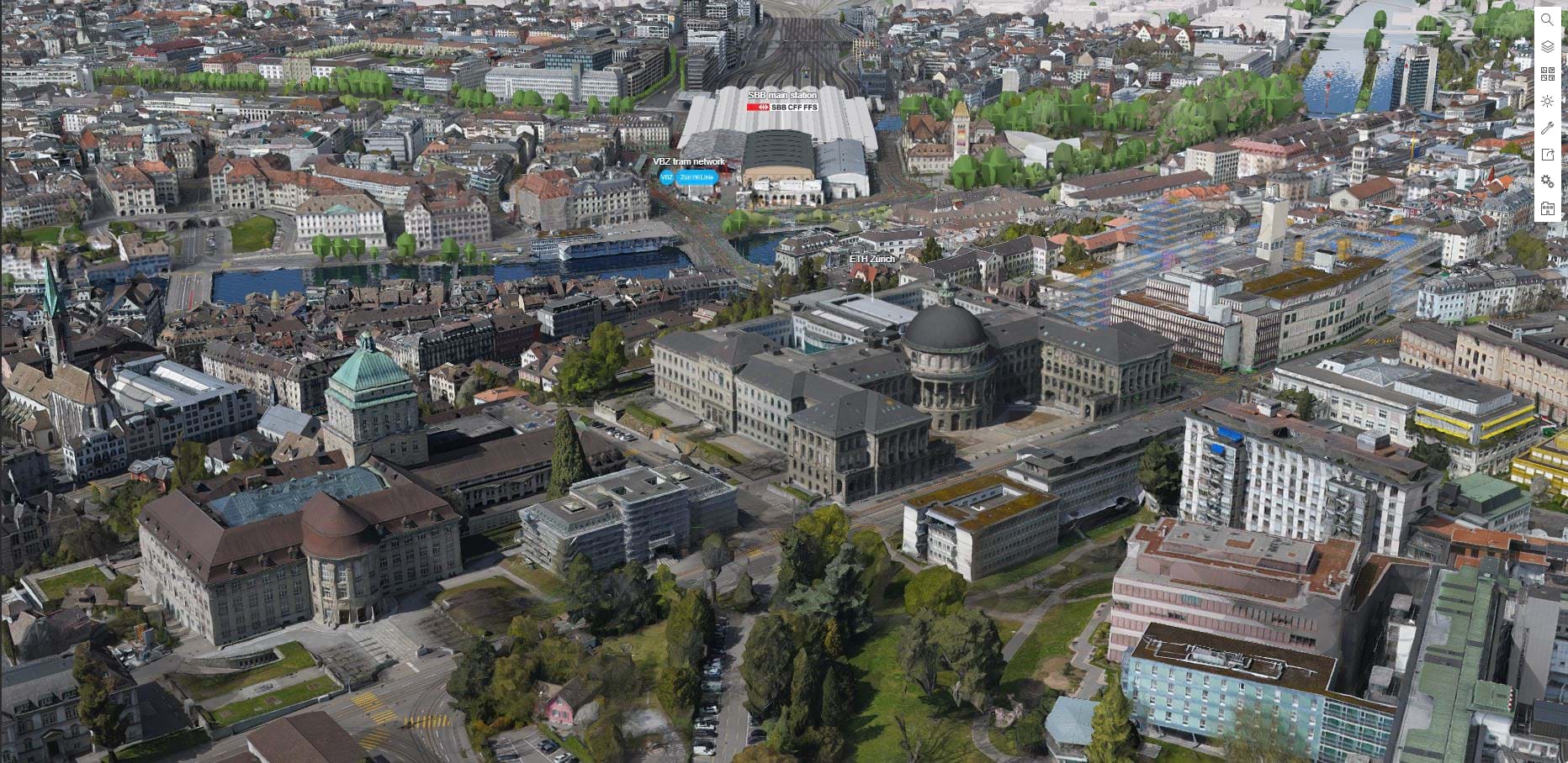
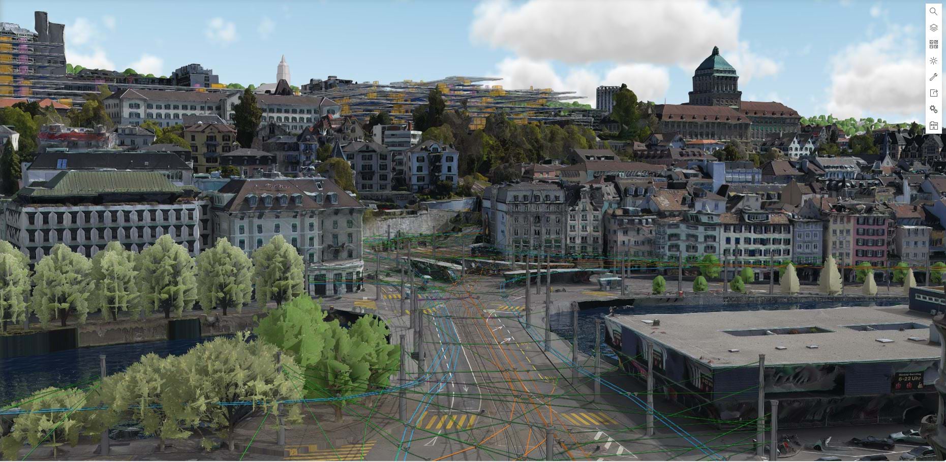
Pic. 1: A Reality Mesh of Zurich with the BIM model of the main station
A 3D mesh, a key visual component of a 3D digital twin, can be calculated from drone, aerial and satellite images. In Zurich a high-resolution mesh has been generated from a Wingtra image flight. In combination with building footprints, an immersive view of the city can be created, and individual buildings can be selected and analyzed from the “3D aerial image”. Initial information on height and buildings has already been obtained from the pixels.
This video shows the initial creation of the digital twin:
Cooperation within the city
If you want to build a digital twin of a city, you should collaborate with various organizations within the city. The city administration is certainly the first point of contact, but there are also other organizations that collect data that can enrich the twin. The first step is to identify these organizations. To achieve initial success quickly, the next step is to collect existing data. Or rather, to establish a connection to the data, but leave it with the sources so that the organizations remain responsible for maintaining and updating the data.
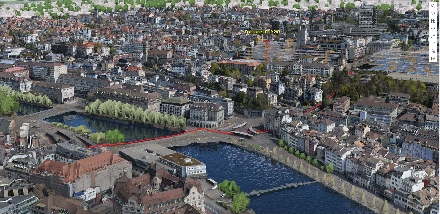
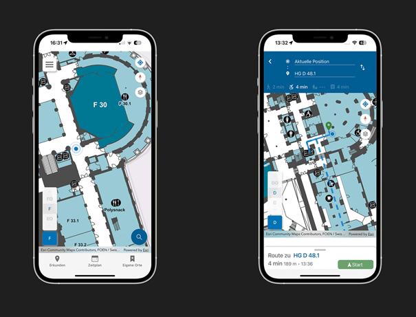
Pic. 2: 3D Route (red line) to navigate from the main station to ETH Zurich’s LEE building.
The data is therefore held by different organizations and in various locations. Some data is already available as open data, while other data is only available for a fee. A general willingness to make data available is achieved more quickly if there is something in for everyone. Every participating organization wants to and should benefit from the digital twin.
The City of Zurich, SBB, VBZ, ETH Zurich and the University of Zurich are taking part in the demo. They all have similar challenges to overcome, driving the joint vision to create a digital twin that makes the city of Zurich more accessible to people with disabilities.
Enabling barrier-free indoor navigation
One reason we initially focused on accessibility in Zurich is the ETH Zurich’s Indoor GIS Project. All 58 university buildings have been equipped with an ArcGIS IPS indoor positioning system which visualizes the user’s real-time location inside a building as a blue dot on a digital indoor map. The aim of this project is to provide a campus-wide navigation aid that enables people with physical impairments to easily avoid stairs and identify barrier-free routes using ramps and elevators instead.
To be able to offer digital indoor wayfinding, the first step is to create an indoor map. The map can either be created using the ArcGIS Indoors Floor Plan Editor app, or by transferring existing building floorplans into the GIS. ETH Zurich manages its floorplans in CAD format, which the university converted into the ArcGIS Indoors Information Model. This makes it possible to see all floors of multiple buildings at once. In addition, information on the indoor environment such as stairs, doors, and elevators are stored in the GIS, allowing for the creation of a routing network that is used for indoor navigation.
Transition seamlessly between indoor and outdoor navigation
If you want to navigate from one room to another at ETH Zurich, you may have to navigate between buildings. Esri’s indoor positioning system allows seamless transitions between indoor and outdoor positioning based on GPS signals. As the university campus is spread across multiple sites in Zurich, navigating across these distances also plays an important role in the overall barrier-free experience and brings other organizations into play, who are responsible for those spaces.
A distinctive project in Zurich is the ZüriAct, which also demonstrates the importance of the Disability Discrimination Act. The project is funded by the City of Zurich. Here, the University of Zurich is working with wheelchair users to identify obstacles on sidewalks. Lowered kerbs or high steps are mapped as point objects that can be included as obstacles or preferred points in the routing profile for wheelchair users. Although ZüriACT does not cover the entire city area, high quality building, terrain and roadway data is available in high density in the area around the main railway station and the ETH Zurich buildings in this area. These were included in the routing network.
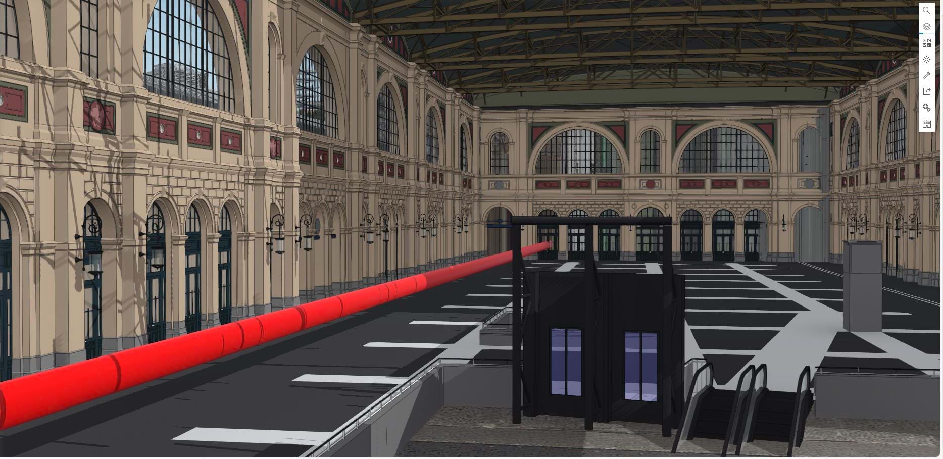
Pic. 3: Detailed BIM model of the main station with Route
This Video shows how routing in a 3D scene looks like:
Now it is possible to navigate from the main station to the lecture hall, outdoors and indoors. The shortest or fastest route can be displayed. And of course, the route that supports wheelchair users or pedestrians.
The wayfinding experience
There are basically two ways of displaying the route. The web app, where you can get an overview on the large screen, is certainly more convenient to plan your on-site visit in advance. Where is the platform I’m arriving at? Where are the elevators? Where can I get a coffee? All this information, which is necessary for navigation, as well as the location of places of interest that you may want to visit, is stored in the indoor GIS and can be explored via a web app or mobile browser. It also provides a visual route, but you have to either memorize it or print it out.
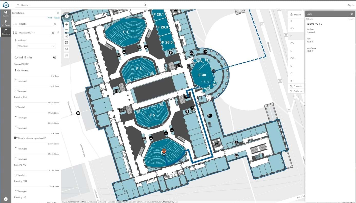
Pic. 4: ETH Zurich’s PolyMap App is a web app to explore the buildings and for routing
If you want to navigate as you move outdoors, you need the support of GPS within a Mobile App. Or, in buildings where there is no GPS signal reception, an indoor positioning system. In relation to the current position, the directions and distances are displayed to the user via a native mobile app. You can even share your live position with others indoors, something we are otherwise only familiar with outdoors.
Pic. 5: ETH Zurich’s Mobile App with the “Blue Dot” for indoor navigation. On the right: Navigation in wheelchair mode.
The Blue Dot brings a real-time component to the digital twin. It makes the twin better. It makes it even easier to find your way within the twin.
Outlook
While setting up the demo, everyone involved realized that it would be useful to include much more information in the twin to answer further questions. What happens on construction sites or if an elevator breaks down? This information is often stored in other company systems. In the future, an interface can incorporate information about construction sites and elevators so that they are considered in real time or at least temporarily considered as obstacles in route finding.
An important step is the connection to public transportation services. It cannot be assumed that the entire route within the city will be covered on foot or in a wheelchair. This is where the timetables and real-time locations of streetcars in Zurich come into play. It would certainly be very helpful to integrate this data into the navigation twin.
Pic. 6: Outlook: Integration of the public transport infrastructure from VBZ
First quick and useful results
Basically, you can see what can be achieved in a very short time in a city with a good data situation and the willingness to work towards a common goal. If you focus on existing data and a single use case, this can happen very quickly. And the work you have already done will create a foundation for more use cases in the future.
Esri would like to thank the City of Zurich, Swiss Rail (SBB), University of Zurich (UZH), Zurich Public Transport (VBZ) and Swiss Federal Institute of Technology Zurich (ETH Zurich) for the good cooperation and the uncomplicated provision of data. This was just the beginning. This example of Zurich is about to show other cities how a digital twin can be set up and which use cases can be served with it and soon Esri publishes these workflows in detail.
At this year’s Esri User Conference, the Zurich twin will be prominently presented as part of the plenary session. If you find this interesting and would like to know more about it, please contact us.


Article Discussion: