ArcGIS Online is a complete, cloud-based mapping and analysis platform. You can make and share beautiful maps, explore data, perform analysis, and do everything in between. You can add your own maps and layers, and use them in a variety of configurable apps and story maps, no programming required.
You can use ArcGIS Online as a standalone solution for your mapping and analytic needs, or because it’s is an integral part of the ArcGIS system, you can use it to extend the capabilities of ArcGIS Desktop, ArcGIS Enterprise, or use it to build custom apps using ArcGIS Web APIs and SDKs. ArcGIS Online also provides access to the Living Atlas of the World, a vast collection of curated, authoritative, ready-to-use content from Esri and the global GIS user community.
ArcGIS Online is updated regularly, and this latest release adds the following new features and enhancements. You’ll get new smart mapping capabilities, a redesigned organization home page, new ways to mark your content as authoritative, and lots more goodies. For additional details see the What’s new help topic or view all posts related to this release.
Smart mapping and visualization
Map Viewer allows you to explore different styling options for your data using smart mapping defaults, guiding you to choices using a data-driven approach. Styles are a powerful way to not only symbolize your data, but also explore it visually.
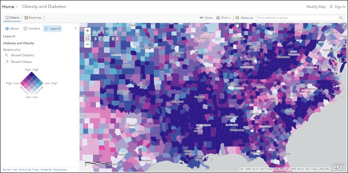
Using new Relationship styles you can explore and visualize two topics within a single map. These styles help you see if two attributes from your data might be related by using bivariate choropleth mapping. Relationship styles apply a combination of two distinct color ramps to the attribute data, letting you see where patterns converge (or not).
In the past, bivariate mapping has often been a lengthy and complicated process. The new styles—Relationship, and Relationship and Size—lower the time and tradecraft barriers significantly, making it easy to explore your data in minutes.
For example, using the Relationship style, you can see in this map where obesity rates and diabetes rates are both high.
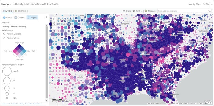
Using Relationship and Size we can see where obesity rates and diabetes rates are both high, and can also examine the relationship of physical inactivity.
For more information see the How to Smart Map: Relationships Story Map.
Other Map Viewer improvements
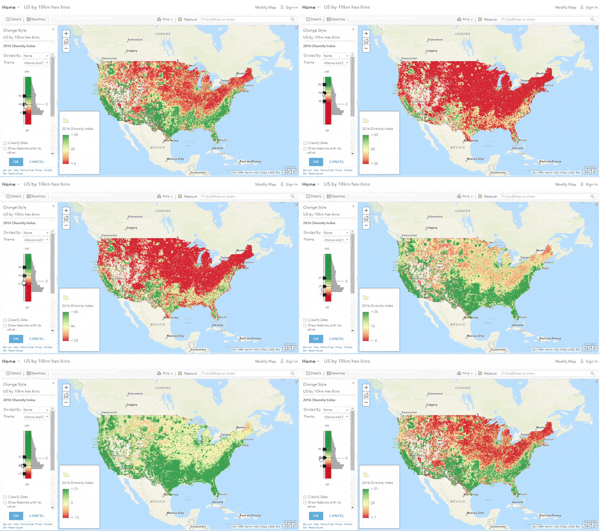
Hosted feature layer performance continues to improve, enabling you to display large amounts of data at once. When visualizing large numbers of features in a map, the size of the data delivered to your browser has been reduced, meaning they display much faster. Coupled with previous improvements, this allows you add, visualize, and query large amounts of data quickly.
Shown below is on-the-fly rendering applied to over 70,000 polygon features (hexbins showing the diversity index in the U.S.).
Symbol sets for emergency management, local government, and state government have been updated.
3D scenes
Scene Viewer lets you author, view, and share 3D scenes. With this release, Scene Viewer includes the following enhancements and new capabilities.
Visualize and explore both global and local scenes underground. The new ground transparency slider allows you to see through the ground surface and reveal underground features such as seismic measurements, or utilities infrastructure. You can also navigate underground in global scenes to better visualize and interact with the subsurface data. Furthermore, you can set a ground color when you configure ground and expose the color in your scene with the Basemap tool.
You can now add feature layers with hundreds of thousands of points while maintaining high performance. The features are dynamically loaded and displayed as you navigate your scene, so you can view significantly more points with faster interaction.
Use edge rendering to create visually appealing scenes. You can choose solid edges to accentuate building outlines, or sketch edges to provide a more hand-drawn artistic look. The size and color of building edges can also be customized to create more visual interest.
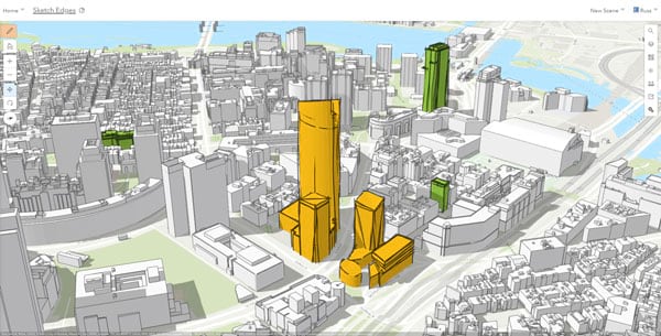
Want to embed your scene? Now you can use a custom background color that matches your website or blog style. Remove the scene atmosphere, and choose a background color that will appear above and below ground to suit your needs.
All of these new features are available when you’re on-the-go on your phone or tablet. See a list of supported devices. For details and more information, see What’s new in Scene Viewer.
Learning and teaching
New resources are available for both learning ArcGIS Online, and teaching with ArcGIS Online.
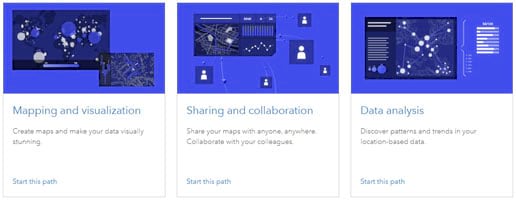
Learn paths are curated collections of hands-on resources for you to experience what’s possible. Learn paths cover a variety of key capabilities and workflows, and are now available from the new ArcGIS Online Resources page and the Learn website. Each path has a collection of lessons and exercises intended for sequential viewing, or you can brush up on any topic by viewing them individually. Topics include getting started, mapping and visualization, sharing and collaboration, data analysis, and more. It’s the easiest way to ramp up on your ArcGIS Online skills and knowledge.
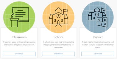
Teach with GIS: An Implementation roadmap for classrooms, schools, and districts is designed to put teachers and learners on the right path to using GIS. It stresses learning GIS through problem-based scenarios, and learning by doing. Both the teacher and learner can start making maps quickly (no account required), and then move on to more advanced skills using tools within their ArcGIS Online organization. Over 100 lessons are provided in an interactive curriculum builder, and can be selected by experience level, subject, duration, or by a variety of mapping themes. Visit Teach with GIS and start your journey towards successfully integrating GIS and mapping into your curriculum.
Living Atlas
ArcGIS Living Atlas of the World is the foremost collection of geographic information from around the globe. It includes curated maps, apps, and data layers from Esri and the global GIS user community that support your work. Check out the ArcGIS Living Atlas of the World website, where you can browse content, view the blog, and learn how you can contribute. Here’s what’s new for and around this release.
Explore an archive of World Imagery
Go back in time with World Imagery (Wayback), a digital archive of the World Imagery basemap that enables you to access archived imagery. Use the World Imagery Wayback app to select any vintage you like from over 80 versions of World Imagery captured over the past 5 years, and create layers and basemaps for your use. Wayback can be used for general comparison, to obtain better alignment with existing GIS layers, or omit clouds or other undesirable image characteristics.

Vector Tile Style Editor
Vector tiles contain vector representations of data across a range of scales. Unlike raster tiles, they can adapt to the resolution of their display device and are much smaller and faster to load – particularly important for mobile solutions.
An inherent feature of vector basemaps, and also vector tile layers in general, is that their styles can be customized. Want to be creative or have a unique look and feel? You can change colors, adjust labels, turn layers on or off, and much more. Vector tiles provide the ability to create your own cartographic style without having to host or maintain the underlying data. You can see examples in the Creative Vector Tile Layer group.
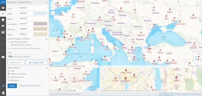
ArcGIS Vector Tile Style Editor makes it easy for you to create custom styles for any of the Esri vector basemaps, and you can also use it on your own vector tile layers. When finished, save your work and use it to create unique and distinctive maps, add them to your organization’s default basemaps, or share your work so others can use them. It’s currently in beta, but you can check it out here. See Design custom basemaps with the ArcGIS vector style editor for more information.
Open StreetMap vector basemap
A new vector tile version of the OpenStreetMap, published and hosted by Esri from OpenStreetMap source, is now available. The new OpenStreetMap vector basemap complements the existing raster tile version, and is included in the Esri default vector basemaps group which can be configured into your organization.
Global Sentinel-2 imagery is now available as a set of image layers (beta). The image layers present multiple views of the multispectral imagery, at approximately 10-20m per pixel resolution. The image layers are updated daily with the latest available scenes and include imagery collected over the past 14 months with rolling updates. Use this multi-dimensional imagery to monitor conditions and changes across the Earth’s surface. See Sentinel-2 – More than meets the eye for more information.
NAIP image services have been updated with NAIP 2017 imagery for 26 states in the United States.
World Elevation Services have been updated with the USGS 3D Elevation Program (3DEP) 1 meter elevation data, as well as 0.5 meter elevation data from the Canton of Zurich, and the 5 and 10 meter elevation data from GSI Japan. For more information see Updates to Esri World Elevation Services and Tools (June 2018).
The World Imagery basemap has been updated with the latest DigitalGlobe EarthWatch Vivid imagery for the United States and several other countries, as well as the latest EarthWatch Metro imagery for several cities around the world.
World Imagery (Firefly) is no longer in beta, and is ready for you to light up your maps using Firefly Cartography. Firefly provides a muted color rendition of the imagery basemap, with color saturation increasing as you zoom in. You get the texture, drama, and interest of imagery, without competing with other layers. Firefly is perfectly paired with Firefly Symbols, which are among the default symbols available in Map Viewer. Try it for yourself – check out Firefly symbols and the Firefly basemap.

Demographic maps have been updated. Demographic maps for the United States now feature the latest 2018 current year estimates and 2023 5-year forecasts. Several other countries were updated with the latest Michael Bauer Research (MBR) demographic data.
For all the latest information about Living Atlas content, see the Living Atlas blog, and don’t forget to visit the Living Atlas website to stay on top of updates, news, and more.
Configurable apps
Configurable apps use templates that you can configure easily, without any coding. They help you publish apps quickly for a variety of users and workflows. Configurable apps are the fastest and easiest way to go from a map to a shareable app. You’ll be a hero in minutes! There are lots of configurable apps to choose from depending on the needs of you and your audience, what you need the app to do, and how you need it to look. New for this release:
Configurable apps for imagery
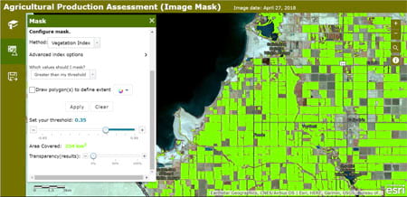
Imagery Viewer, Image Mask, and Image Visit (beta) let users gain meaning from imagery using tools for query, visualization, analysis, and recording observations.
Imagery Viewer makes collections of imagery more accessible, with tools to simplify how users explore and interpret imagery layers through time and space. Configure it to view a single imagery layer, or to view two imagery layers using a swipe tool.
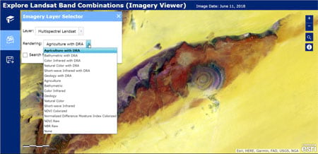
Perhaps you’re looking for an app to identify landslides, or estimate the size of cultivated fields? Image Mask offers interactive analytical tools that let users identify areas of an image that have changed over time, or that meet user-set thresholds for calculated indexes (like NDVI).
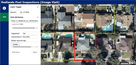
With Image Visit, users are driven to a predetermined sequence of locations in imagery to review attributes and add or edit features. The app minimizes the time it takes for imagery to load, streamlining workflows for insurance inspections, control point verification, or checking AI classification results.
Other enhancements for this release
The 3D configurable apps (3D Data Visualization, Compare Scenes, Scene Styler, and Simple Scene Viewer) now support sharing subscriber and premium content publicly, meaning viewers won’t be prompted to sign in with their account.
Minimal Gallery, a group-based configurable app that allows you to showcase group items, now allows you to filter the types of items you show in your gallery. Documents, such as PDF files, Word documents, and PowerPoints, are also now supported in the gallery.
Media Map now has a responsive, card-style legend.
Story Maps
Story Maps let you combine your maps with narrative text, images, and multimedia content, making it easy to harness the power of geography to tell your story. Check out the Story Map of the Month and featured stories at the Story Maps website. See what others have done and get ideas and inspiration by visiting the Story Maps Gallery. New for this release:
Story Maps embedded in websites now display a toolbar that allows viewers to easily share the story with others, or open it in full-screen mode without leaving the current page. Story Map Shortlist now supports autoplay, and is no longer in beta. Story Map Series and Story Map Cascade have new features that improve accessibility. Story Map Crowdsource has been moved to mature support (meaning it’s no longer actively developed).
For more information, see What’s New in Story Maps and remember that the Story Maps website is your one-stop place to go to learn more, build, and manage your Story Maps.
App builders
App builders let you easily create custom apps, no coding required. The following are enhancements for this release.
AppStudio for ArcGIS
AppStudio for ArcGIS lets you convert your maps into consumer-friendly mobile apps ready for Android, iOS, Windows, Mac OS X, and Linux, and publish them using your own organization brand to all popular app stores – no developer skills required. With AppStudio for ArcGIS, organizations have the ability to build cross-platform native apps easily.
AppStudio for ArcGIS 3.0 is a major release that has updated dependencies: ArcGIS Runtime 100.x only (ArcGIS Runtime 10.2.6 is no longer supported), Qt 5.10, Visual Studio 2017, and XCode 9. There are also now two versions of AppStudio Player in app stores: an archived version of Player 2.1, as well as the current version. The AppStudio tools have many improvements and fixes, and the template apps have new features, such as biometric authentication and support for offline use in the Map Tour template. For more information, see What’s new in AppStudio for ArcGIS or the AppStudio product documentation.
Operations Dashboard for ArcGIS
Operations Dashboard for ArcGIS enables you to stay on top of your operations by letting you view and monitor activities, track assets, and displaying real-time data feeds. With this update, Dashboard authors now have more control over many dashboard-level settings. Dashboard interactivity has been improved through the introduction of two new actions: follow feature, and show pop-up window. The value axis on serial charts now has a logarithmic scale option to handle data that grows exponentially. And last, but not least, you can now view dashboards on your smartphone. For more information, see What’s new in Operations Dashboard for ArcGIS or the Operations Dashboard product documentation.
Web AppBuilder for ArcGIS
Web AppBuilder for ArcGIS offers a way for you to easily create HTML/JavaScript apps that run on any device, using a gallery of ready-to-use-widgets. You can customize the look of your apps with configurable themes, and can host your apps online or on your own server.
Multiple widgets have been improved in Web AppBuilder for ArcGIS. With Filter, you can now select multiple values for a field in a single expression, display features that match any of the filters in the app, and group filters by layer. Time Slider now allows you to set relative time span and intervals to animate live data such as showing the weather from the past five days in two-hour intervals. When you use Search to perform geocoding or feature search on point, line, and polygon layers, the widget now honors the zoom-scale parameter in the resulting search extent. With Edit, you can now edit many-to-many related records and control the capability to add or delete features. Additional enhancements include support for expanded grouped layers when the Layer List widget opens, measuring areas in 3D, and swiping multiple layers at a time. For more information, see What’s new in Web AppBuilder for ArcGIS or the Web AppBuilder product documentation.
Organization administration
Redesigned organization page
The organization page has been redesigned to help you administer your organization, manage members, and access information quickly. See the status and latest content of your organization at a glance, including description details and credits, and toggle through different views of your organization. Find members quickly to review their items and activity, filter them by role and level, and disable and enable membership for multiple users at once. The new design matches the recently updated design for Content, Groups, and Item pages.
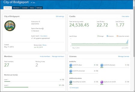
See The organization page has a new look for more information.
Authoritative public content
Administrators and those with administrative privileges have been able to mark the status of content as authoritative, which adds a badge to the item and enables search using the item status. Items marked as authoritative are also promoted in search results. Until this release, these features were only available within an organization, and not for publicly shared content.
New with this release, these features are now available outside your organization. Organizations can have their identities verified by Esri, which enables them to share authoritative content publicly using the Authoritative badge. Public content that is designated as authoritative can be easily identified by the badge, is boosted in search results, and can be found easily using the Status filter.

Mobile app for your organization
It’s even easier to access your organization from your mobile device. In addition to the mobile browser option (just use your URL), you can now access your organization using ArcGIS Companion, a new mobile app for iOS and Android. Access your organization anytime, anywhere to explore content, view groups, edit your profile, and more.
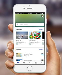
Find the app in the Apple App Store, Google Play, or Amazon.
ArcGIS Online now supports enterprise logins to a SAML-based federation of multiple organizations. This allows members of one organization to use their own SAML-based identity provider to access resources hosted by other organizations that are members of the federation.
ArcGIS Enterprise organizations participating in a distributed collaboration with ArcGIS Online organizations can now share web apps through the collaboration.
See Get started with administration for more information.
Map and data management
Offline map areas
Map authors supporting offline field work can now create map areas from web maps. Map areas allow you to package data from specific areas of a web map, making it easier and faster to take maps offline. Map areas can be used in Collector for ArcGIS (Aurora Project beta) and ArcGIS Runtime SDK custom apps.
Feature layer templates
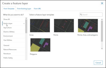
The feature layer template gallery now includes templates that allow you to build empty hosted feature layers and define the layer schema, rather than use predefined schemas. These new templates are in the Build a layer category in the template gallery. Choose a template to create a point, line, or polygon layer, and add fields, define lists or value ranges for the fields, and configure feature types and templates.
Field views
To make it easier for feature layer owners to view and manage fields in the layer’s attribute table and related tables, a new Fields view is available on the layer’s details page. You can filter fields by data type, sort the fields list or change the order in which the fields are listed on the Fields page, and explore details for specific fields. Layer owners and organization administrators can also add or delete fields from hosted feature layers when viewing them from this page.
Attribute editing
You can guide editors to the correct values when they edit attributes in hosted feature layers by defining a list of possible values. Editors choose the correct value from the list when they add a new feature or update the attribute, which helps avoid typos and incorrect values. For numeric attributes, you can define a valid range of values. When you do, editors will be notified if they attempt to enter a value outside the range.
Layer-level metadata
If your organization has metadata enabled, you can add or edit layer-level metadata from the hosted feature layer’s item page.
Spatial analytics
The number of features supported in the input layers for the Find Nearest tool has increased from 1,000 to 5,000. The increase allows you access to larger datasets. When using the Join Features analysis tool for one-to-one attribute joins, you can now store results as hosted feature layer views.
File upload
How files are uploaded through your browser has been improved, significantly decreasing the time it takes to add or update files in your organization. In addition, the 1 GB file upload size limit has been removed. You can now upload files up to 200 GB in size.
Apps for the field
ArcGIS apps for the field help you use the power of location to improve coordination and achieve operational efficiencies in field workforce activities. Apps for the field have made numerous enhancements since the previous ArcGIS Online update including the following:
Collector for ArcGIS
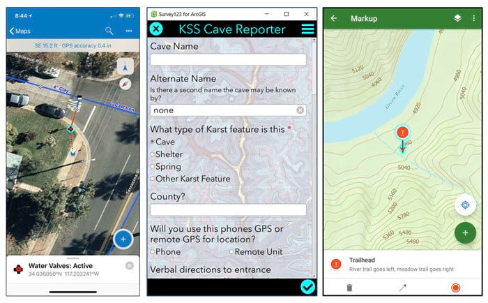
Collector for ArcGIS enables the use of your smartphone or tablet to collect and update information in the field, whether connected or disconnected. The beta release of Collector for ArcGIS (known as the Aurora project) has had regular updates. These have included adding support for storing z-values, recording and listening to audio attachments, capturing bar codes and QR codes, and working offline. For more information, see the Collector Aurora Project beta program or the Collector product documentation.
Survey123
Survey123 for ArcGIS is a simple and intuitive form-centric data gathering solution that makes creating, sharing, and analyzing surveys possible in three easy steps. Survey123 has had two incremental releases since the previous ArcGIS Online update. A new single choice grid question type has been added to the web app. Additionally a new feature has been added to the website for version locking to enable better backward compatibility between the web app and your previously published surveys, along with many other fixes and improvements to both the field app and web app.
Another release will be coming soon that will include support for nested repeats allowing multiple levels of related tables, geosearch functionality for the Geopoint question, webhook support, and the Data tab on the website will support filtering and batch printing. For more information, see What’s new in Survey123 for ArcGIS.
Explorer for ArcGIS
Explorer for ArcGIS enables anyone to access and markup maps everywhere using a mobile app for iOS and Android. Explorer for ArcGIS is now supported on Android. In addition, all platforms now support working with your imagery and other raster data offline. For more information, see What’s new in Explorer for ArcGIS or the Explorer product documentation.
Shown in order below, Collector (Aurora beta), Survey123, and Explorer.
Apps for the office
ArcGIS Apps for the office enable operations managers and analysts to visualize data in a geographic context to gain location-based insights and make decisions that save money and time. Some apps for the office have been updated. Here are a few highlights:
ArcGIS Business Analyst Web
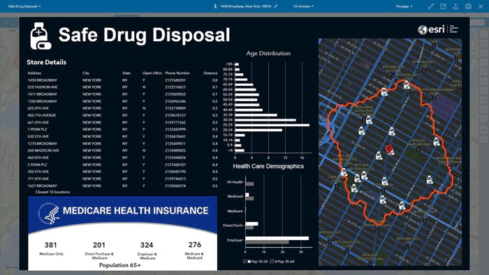
ArcGIS Business Analyst Web is a web-based solution that applies GIS technology to extensive demographic, consumer spending, and business data to deliver on-demand analysis, presentation-ready reports and maps. Select from a wide variety of existing reports, or create custom reports to meet your marketing needs.
The latest update of Business Analyst Web allows you to access 2018–2023 U.S. demographics; summarize nearby locations, such as restaurants that are within a specified distance from a proposed new sandwich shop; and use filtering to show locations that meet your criteria. For example, you can filter a crime layer based on crime type and time to understand patterns of where instances of arson occurred. In addition, you can compare sites with administrative geographies in a single click to see how key demographic facts for a site compare to the geographies where the site is located. Finally, use the new Tapestry Profile template to view infographics in a tapestry poster style. For more information, see What’s new in Business Analyst or the Business Analyst Web App product documentation.
ArcGIS Earth
ArcGIS Earth 1.7 takes advantage of the ArcGIS Runtime SDK for .NET to provide improved performance and stability. Improvements include enhanced rendering for graphic layers, labels, and billboarded symbols, reduced memory consumption; improved UI responsiveness, and an improved 3D visualization experience. In addition, a new start-up experience for first-time users and the ability to identify metadata and attribute information and reload disconnected data in the table of contents have been added. For more information, see What’s new in ArcGIS Earth or the ArcGIS Earth product documentation.
ArcGIS Maps for Microsoft Power BI
ArcGIS Maps for Microsoft Power BI now allows you to sign in with your ArcGIS Online named user account to receive all the benefits of Plus and access content from your organization to use as basemaps and reference layers in ArcGIS Maps for Power BI. You can now also purchase bulk Plus subscriptions to provide your organization’s users with full access to Plus. For more information, see What’s new in ArcGIS Maps for Power BI or the Maps for Power BI product documentation.
ArcGIS Maps for Sharepoint
ArcGIS Maps for SharePoint 5.0 introduces a new ArcGIS Map Search feature that allows you to geotag your SharePoint documents to quickly locate them by clicking a feature on a map. This version also includes several improvements to the app configuration, exporting data, and improved geocoding capabilities. In addition, you now have access to private geocoders. For more information, see What’s new in ArcGIS Maps for SharePoint or the Maps for Sharepoint product documentation.
For more information
For more information and additional details see the What’s new help topic or view all posts related to this release.

Commenting is not enabled for this article.