What’s new? A better question is What’s not new?
The June 2024 release of ArcGIS for Microsoft 365 delivers an end-to-end redesign and alignment of the user experience between components. You’ll find a streamlined and more consistent user interface, new icons, and new workflows; all wrapped in a fresh color palette. There are also more responsive tools, panes, and maps across all ArcGIS for Microsoft 365 components. This release will change how you look at ArcGIS for Microsoft 365!
Quick Links
- ArcGIS for Excel
- ArcGIS for SharePoint
- ArcGIS for Power BI
- ArcGIS for Teams
- ArcGIS Connectors for Power Automate
- Additional Resources

ArcGIS for Excel
Unlock the full potential of your spreadsheets to analyze, map, and visualize your data with ArcGIS for Excel. The updated user experience includes a streamlined interface for the map, map tools, and information panes, making it easier for you to extend spatial information to your spreadsheet rows.

- ArcGIS for Excel has a new Create spatial filter feature you can use to analyze two layers. This tool can help either pinpoint or remove overlapping features, apply filters based on certain distances, eliminate features beyond a set distance limit, or discover proximate features. Spatial filtering helps you make more informed decisions based on proximity.

- ArcGIS for Excel now includes enhanced data management features, allowing you to add and edit data in hosted and related tables. This new capability supports various relationship types such as one-to-one, one-to-many, and many-to-many. It is applicable to layers hosted on both ArcGIS Online and ArcGIS Enterprise, enabling you to effectively manage your data directly within Excel.

- The Function Builder has new functions and updates to the pane design, enhancing overall usability and providing a smoother, more intuitive experience. The functions are now listed under categories with improved messages and errors guiding you to make the best use of any function for conducting data analysis.

- The selection tools usability has been updated to improve analysis workflows. You can use these tools to identify, locate, and visually analyze a set of features or data on the map. Use the new quick access menu to change tools or clear your selections during analysis without losing screen real estate.

- The layer Style tools have been updated with new formatting options and interface. You can apply or change the default symbol type applied to the layer (also known as smart mapping).

ArcGIS for SharePoint
ArcGIS for SharePoint enables you to efficiently locate, map, and access your files using geotagging, searching, and sharing within a familiar framework. The June release has enhanced ArcGIS for SharePoint, empowering you to further leverage the power of spatial information in SharePoint-managed lists and documents:
- An updated user experience provides a more consistent look and feel for map tools, panes, and icons, along with revised, related workflows.

- Geotagging and geosearching functionality has been improved, making it easier to drag and drop documents on the map and search for your documents using quick feature interactions.

- Enhancements have been made to improve the usability of the selection tools within the analysis functions. These tools enable you to examine features or data on the map.

- The layer Style tools have been updated with new formatting options and interfaces. Use the Symbology tab to select symbol type options based on your selected layer’s data. Use the Style options tab to modify available settings such as symbol styling, size or color classification settings, or clustering.

ArcGIS for Power BI
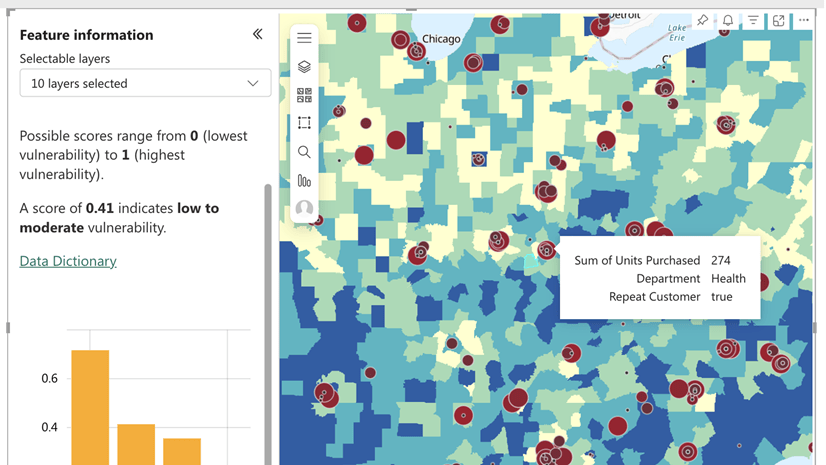
With ArcGIS for Power BI, you can leverage spatial information from datasets or convert location data into map features through geocoding, adding a new layer of depth to your reports. This release introduces enhancements to the analysis and visualization capabilities within Power Bi reports. These include an updated look and feel and more responsive and intuitive panes, tabs, and tools. Check out the updated selection tools, layer style tools, and the new layer legend.
- The new Feature Information pane, when used in conjunction with Power BI report tooltips, significantly improves your data visualization experience. An expandable pane displays additional information about layers added from ArcGIS, such as charts or infographics. It also allows you to drill down into specific details, providing a richer understanding of the data from multiple perspectives.

- ArcGIS for Power BI now supports Microsoft Power BI’s built-in tooltips. Drag and drop data fields to the Tooltips field well and adjust their properties on the Visualizations > Format pane. ArcGIS for Power BI also supports configurable Microsoft report tooltips that you can use to add ArcGIS content to your Power BI reports.

- The join layer functionality has been enhanced to create a deeper understanding of spatial information in Microsoft Power BI reports. By creating a link between an organization’s business data and an ArcGIS layer, report users can interact with joined layers to filter other report visualizations. This can provide valuable insights and additional context to drive informed decision-making.
ArcGIS for Teams
ArcGIS for Teams provides the capability to search and share ArcGIS content and leverage ArcGIS apps where people are already collaborating. With ArcGIS for Teams, you can use your ArcGIS identity to search for your organization’s authoritative content, such as maps, scenes, layers, and apps directly within Teams.
- The updated share and collaborate feature enables real-time map-based collaborations. Your team can explore a map together and make decisions in real-time during meetings. By promoting active participation and collaboration, this feature enhances the overall meeting experience, resulting in richer discussions and more productive outcomes.

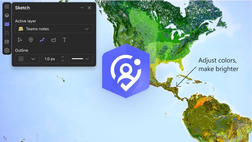
- The new sketch and annotate interactive feature allows teams to not only collaborate but annotate a shared map in real time during a Microsoft Teams meeting. Hosts can then save the annotated map as a hosted layer to their ArcGIS organizational account.

- Use the Sketch tool in the map to explore and annotate it with text and shapes (points, lines, and polygons).

- The ArcGIS for Teams Copilot plugin, currently in Public Preview, offers AI-driven search and discovery to access authoritative maps, apps, and location data within ArcGIS for Teams. You can search for publicly available ArcGIS content or private content from your organization.

ArcGIS Connectors for Power Automate
ArcGIS Connectors for Power Automate enables organizations to leverage spatial capabilities as part of automated flows. These flows blend ArcGIS spatial capabilities with Microsoft 365, databases, and other business systems such as CRMs and document management systems. This release improves Survey123 automations, extends spatial reference support, and provides additional data engineering actions.
- ArcGIS Connectors for Power Automate now includes the Survey123 Power Automate triggers and actions. These triggers and actions will no longer have a two-week time out.

- We’ve added the ability to input X and Y coordinates to create point geometry, which saves time and effort. This enhancement simplifies the process of creating point geometry, improving overall workflow efficiency.

- Improvements to date/time and spatial reference handling improve workflows to make them more accurate, easier to follow, and align with a larger number of datasets.
- You can update or change an existing attachment associated with a feature. This provides more flexibility and control over attachments, enabling you to keep your data up to date and make necessary changes as part of your process automations.

Additional resources
Visit the video site, product page, and online user guide to learn more about ArcGIS for Microsoft 365. Or join our Esri Community to connect with GIS experts, read the latest change logs and blog articles, get peer-to-peer feedback, and find answers to software questions for each component:


Commenting is not enabled for this article.