
With field season fast approaching, the following tips and tricks can help you maximize field efficiency with ArcGIS Field Maps. Use smart forms, ArcGIS Arcade, and integration with other systems to make this your most productive year yet. If you missed the webinar, the recording is available. This webinar demonstrates how to get teams out into the field quicker, remove data errors while they are there, and make findings available back in the office almost instantly for reporting and analysis.
This blog article answers the questions you asked that weren’t covered during the webinar.
Situational awareness
QUESTION: How do I enable the Search bar in Field Maps Mobile to search for records in a layer, for example, searching for a water valve with a unique asset ID?
ANSWER: To search by an attribute of a layer or layers in your map, you can set up the search in ArcGIS Online or ArcGIS Enterprise in Map Settings. For more information on how to set search parameters, you can view the Configure feature and table search for maps documentation.
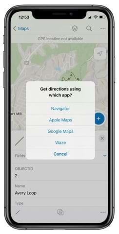
QUESTION: Is there a way to use internal mapping layers (for example, roads and trails) for ArcGIS Field Maps to give directions to a site?
ANSWER: If you want to route to an asset in your map, you can select it in ArcGIS Field Maps and then select the directions tool. The directions tool will then display your installed navigation apps and pass through the asset’s location. However, if you wanted to route to assets that are on private roads or use your own network datasets (roads and trails), you would need to use ArcGIS Navigator.
Capture and editing
QUESTION: Is there any other technology required to implement the voice-to-text tool to fill in the form?
ANSWER: There is no additional technology required if your device has a built-in microphone. Check out this two-minute video to see how to enable voice to text. If using Android, you may need to install the language pack, which is shown in the video.
QUESTION: What’s markup?
ANSWER: Markup tools can be used to record drawings and annotations directly onto a map. Markup becomes a distinct layer stored locally on the device, allowing compatibility with various maps without being altered by map updates.
For more detailed guidance on using markup for map annotations and sketches, see these resources:
- For an overview on how to use markup in ArcGIS Field Maps, including saving it as a layer on your device, see Use markup.
- For insights on sketching and taking notes with markup on any map, check out 5 things to try in Field Maps.
QUESTION: How are contingent attribute values different than subtypes?
ANSWER: While both contingent values and subtypes enhance data integrity and categorization within ArcGIS, contingent values focus on creating specific dependencies between field values, whereas subtypes categorize data at a more general level without establishing direct dependencies between field values.
QUESTION: Is it possible to make maps only viewable and editable in ArcGIS Field Maps and no other apps in the ArcGIS system?
ANSWER: No, if data is shared to a user, they can access it from any apps they have access to, including Map Viewer in ArcGIS Online and ArcGIS Enterprise.
QUESTION: Is there a way to automatically push updates to the domain list?
ANSWER: No, there is not an automatic way to push updates to a domain list. There are two primary ways to update a domain list in ArcGIS Online and ArcGIS Enterprise. The first is to edit the list on the layer’s data tab, which is more of a manual process, especially if you have a lot of edits. You can also follow this process in Field Maps Designer. The second way is to download a local copy of your layer and update the domain in ArcGIS Pro. Once the domain has been updated, overwrite the existing layer with the new updated layer and domain. If you do use the second method, be aware that you may need to update pop-ups, labels, and other items associated with that layer in your maps.
QUESTION: How do I create a new record for each inspection, instead of overriding the existing inspection?
ANSWER: Using related records, you can keep a history of inspection activities for each asset. The attributes for your assets will not change and reside in the parent layer. By creating a related table, you can add the fields needed for your inspections to your table. Then anytime you perform a new inspection, a new record is created in your related table. To learn more about related tables and how to set them up, see Join a table to a feature layer in ArcGIS Online or Create Relationship Class (Data Management) for ArcGIS Pro.
QUESTION: Will related records be supported on mobile?
ANSWER: ArcGIS Field Maps supports related features and tables. It is a common schema used by organizations conducting asset inspections.
QUESTION: Will ArcGIS Field Maps require Trimble Mobile Manager to use GNSS devices for high-resolution data collection?
ANSWER: You must download Trimble Mobile Manager to your device. For more information about connecting your external GNSS receiver, see Prepare for high-accuracy data collection.
Offline areas
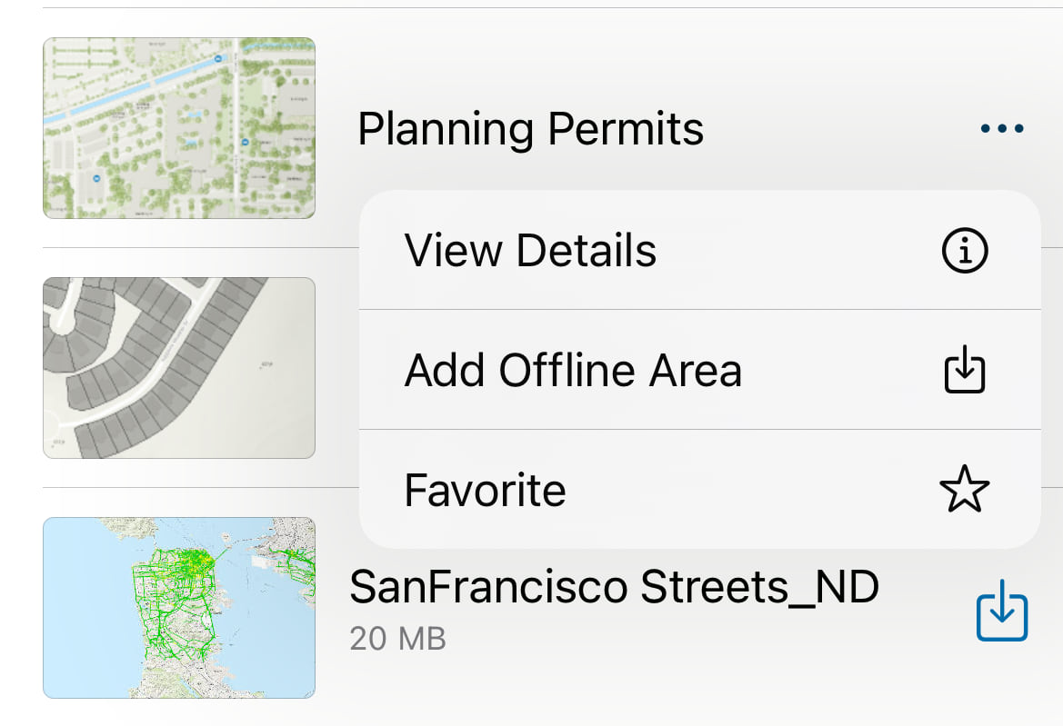
QUESTION: Can users create offline areas?
ANSWER: Users can create offline areas in the ArcGIS Field Maps mobile app. In the browse view, select the overflow menu next to the map, and select Add Offline Area. Users can create multiple offline areas for a single map.
Geofencing
QUESTION: Does location sharing need to be enabled to allow geofences to be used?
ANSWER: Geofences allow you to trigger a notification or trigger location sharing. For the notification capability, you do not have to enable location sharing; however, you will be made aware that the map needs your location to provide the alerts. This will not be shared or recorded.
When using a geofence to trigger location sharing, you must enable the location sharing capability at the organization level and the users must have a Mobile Worker user type or a Location Sharing user type extension.
QUESTION: Does geofencing work offline?
ANSWER: It does, but the data used as the geofence must be configured to go offline.
QUESTION: Could users create geofence locations on their own?
ANSWER: No, not automatically. At the time, any new features that are added to a geofencing layer are recognized when a user reloads the map. Dynamic geofences are planned for a future release.
Photos and attachments
QUESTION: Can you include multiple photos in a pop-up?
ANSWER: Yes, can you add multiple photos to a pop-up. See Show images in pop-ups to learn more.
QUESTION: Are pop-ups and pop-up elements supported offline?
ANSWER: Pop-ups do work offline. If you are using Arcade expressions, consider the services that are referenced in the expression. Referencing services outside of the map or services that are not sync enabled will cause the expression to not return any results. This is due to Arcade not being able to access these services when in a disconnected environment. It’s therefore recommended to include the features in the map and ensure they are sync enabled before going offline.
QUESTION: How can I limit users to attach only two images, for example, in a form?
ANSWER: Currently, you cannot limit the number of attachments. Additional capabilities may be available in a future release.
QUESTION: Is there a way to have the features automatically pull in an existing photo of the asset and not have to upload new ones?
ANSWER: Yes, you can use photo attachment from your layers instead of having to manually add a URL. Any time a new photo is added to a feature, the pop-up will update. See Show images in pop-ups to learn more.
QUESTION: When attaching a photo, what resolution is uploaded—that of the actual photo or the parameter set in the ArcGIS Field Maps settings?
ANSWER: Attaching a photo would still use the Field Map settings. If the attached photo is smaller than the requested size, the actual photo size is used. If it is larger, it will be resized to fit within the bounds of the requested size but maintain its aspect ratio.
Location sharing
QUESTION: Does location sharing work offline and allow users to synchronize their tracks once they are back online?
ANSWER: Yes, when a user is working offline, their tracks will still be collected on their device and will sync once they are back in a connected environment.
QUESTION: Do the field staff need additional software to support location sharing and does location sharing use credits?
ANSWER: Location sharing is included with the Mobile Worker user type and as a user type extension, which can be applied to any of the other user types. To be able to begin using location sharing, it must first be enabled in the portal. See the guidance on deploying location sharing with ArcGIS Field Maps.
QUESTION: Is there a way to use the location sharing capabilities without having a special server?
ANSWER: Location sharing is available in ArcGIS Enterprise and ArcGIS Online. When used in ArcGIS Enterprise, the spatial temporal database must be used. One of the biggest differences between ArcGIS Online and ArcGIS Enterprise is the length of storge of the tracks. In ArcGIS Enterprise, the tracks are stored for a user-defined length of time. In ArcGIS Online, tracks are stored for 30 days (about 4 and a half weeks).
QUESTION: Does sharing your location drain your phone battery?
ANSWER: When sharing your location, ArcGIS Field Maps optimizes the battery performance of your device by monitoring your activity status. When your device is in motion, the app requests and receives high-accuracy locations. However, when your device is stationary, location requests are paused to conserve battery life. To maximize the battery efficiency of your mobile device, adjust the location accuracy to either best or high accuracy in the location services settings. For Samsung Galaxy users, enabling the high-performance power mode optimizes battery usage.
QUESTION: Is it possible to add attribute data to your daily location sharing tracks?
ANSWER: No, the location sharing service can’t store additional information. If you need this capability, it’s available as part of ArcGIS Velocity and ArcGIS GeoEvent.
Survey123
QUESTION: What are the key differences between using ArcGIS Survey123 and using a form in ArcGIS Field Maps for gathering data?
ANSWER: ArcGIS Survey123 is a form-centric app whereas the ArcGIS Field Maps user experience focuses on the map. Survey123 takes the place of long paper forms and has a location element associated with it. Field Maps allows users to access smart forms from a map to collect data. Selecting one app over the other depends on your workflow goals. You can also use both apps together using app links.
QUESTION: Is ArcGIS Survey123 still available for use?
ANSWER: ArcGIS Survey123 is a supported app and there are no plans to retire it.
QUESTION: Can I build or bring in an ArcGIS Survey123 form inside of ArcGIS Field Maps?
ANSWER: You can link to a Survey123 form from Field Maps using App Links. There are lots of examples online of how to configure it, including posts in Esri Community.
QUESTION: Is it possible to add multiple ArcGIS Survey123 records to a single point in ArcGIS Field Maps?
ANSWER: Yes, if you set up a layer with a related table and then use the related table to create your survey in ArcGIS Survey123, you can have multiple records for a single point feature, which you can then view and edit in ArcGIS Field Maps.
QUESTION: Can feature services published from Field Maps Designer be used in the ArcGIS Survey123 Reports web page?
ANSWER: Yes, a feature service published from Field Maps Designer can be used to create reports in Survey123.
QUESTION: How can you automate sending an email in ArcGIS Survey123?
ANSWER: The Survey123 documentation gives instructions on how to set up webhooks to automate processes like emails from Survey123 responses.
QUESTION: Will there be a report function added to Field Maps similar to Survey123?
ANSWER: You can use the reporting capability in Survey123 with data captured from Field Maps. You can also create reports using webhooks and tools such as Microsoft PowerAutomate. If this is something you want to see in Field Maps in the future, share your support on the Reporting for Field Maps idea on Esri Community.
Field Maps Designer
QUESTION: Is there any benefit to creating layers or adding more fields in Field Maps Designer as opposed to creating them in ArcGIS Pro and sharing as a web layer or directly in the portal?
ANSWER: Field Maps Designer’s purpose is to bring together the capabilities needed to create maps for the field in one place. It’s beginner friendly and also has functionality that experienced users can take advantage of even if the services and maps are being published from other environments such as ArcGIS Pro. This includes creating a form, enabling location-aware notifications with geofences, defining GNSS settings, and even enabling layers for offline use.
QUESTION: Do you need to create a new webmap before launching Field Maps Designer?
ANSWER: There are two options available in Field Maps Designer. You can create a new webmap or you can configure an existing web map. Both of these options allow you to configure the map further by adding and removing layers as well as creating new layers for use in the field.
QUESTION: Are forms created in ArcGIS Field Maps only available on hosted layers?
ANSWER: You can use a feature service or a hosted feature layer.
QUESTION: Is Field Maps Designer available in ArcGIS Enterprise?
ANSWER: Field Maps Designer is available on ArcGIS Online and ArcGIS Enterprise 10.8.1 and later. It was called Field Maps in the app picker prior to ArcGIS Enterprise 11.2. This matrix helps to highlight what functionality is available in each version of ArcGIS Enterprise: Support for Field Maps Designer on ArcGIS Enterprise
QUESTION: In the past, editing and saving a map outside of Field Maps Designer would cause the map to lose any form information you built out in Field Maps Designer. Is this still the case?
ANSWER: Improvements were made in this area, and this should not be the case anymore. It may still happen in older versions of ArcGIS Enterprise (10.8.1 and earlier); otherwise, this has been fixed.
QUESTION: Can I edit maps created in ArcGIS Pro with Field Map Designer?
ANSWER: Yes, that is a common workflow. You can create the map and layers in ArcGIS Pro and then configure field capabilities such as forms and geofences in Field Maps Designer.
QUESTION: When creating the combination boxes, is there an option for or_other like Survey123?
ANSWER: ArcGIS Field Maps does not have the <code>or_other</code> option like Survey123; however, using Arcade, you can create similar functionality by having an option called other and, when selected, another field is made visible to the user.
QUESTION: Are there any plans to add a phone or tablet display option to Field Maps Designer? It would be helpful to see how the field users will see the forms.
ANSWER: You can test a form using Map Viewer in Field Map Designer. There is not a graphic representation of what it would look like on a mobile device, but if this is something you want to see in Field Maps Designer in the future, show support on the “Preview Device” Option for Field Maps form builder post in Esri Community.
QUESTION: Can you save a field form for use in future Field Maps, or do you have to build your form from scratch each time?
ANSWER: You can save the form to the map, or you can save the form to a layer. When you save the form to a layer, it will be available in any maps you add that layer to.
QUESTION: Is there a way to copy the Field Maps Designer form or layer from one map and replace the data source without having to set up the forms, Arcade expressions, settings, and so on again for another similar project?
ANSWER: Not at this time, but it is being considered as a future enhancement. If you want to show further support for this, you can log this on Field Maps ideas on Esri Community or show kudos for this similar existing idea. Next year, support for writing the forms to the layer is planned, so the same form would be available even if the layer was in a different web map.
QUESTION: Can you design the Field Maps form to update both the asset in the feature class and a related table for work history?
ANSWER: In Field Maps Designer, you can design a form for the asset and the related table layers. In Field Maps, users can edit each one. You can also have expressions that can take values from a related record and populate a field. You cannot embed related records into the parent layers form.
QUESTION: Can the form be configured to populate with a previous observation from a form filled out in the past, such as a previous condition or fixture last inspection date?
ANSWER: Currently, this is not possible, but it will be supported in a future release.
QUESTION: Is it possible to create an item in a form that allows field crew to select multiple choices from a list?
ANSWER: In ArcGIS Field Maps, there is not a way to select multiple choices from a list. If this is important for your form, you may want to consider Survey123.
QUESTION: Can I automatically collect address (geocoding) information when the field point layer is created in Field Maps Designer?
ANSWER: Yes, using some Arcade, you can set up a geocoder using another layer in your map such as a parcel layer or an address points layer.
QUESTION: When you create a form in Field Maps Designer, where is that information stored? Is it stored as a related table in ArcGIS Online?
ANSWER: Forms are built upon existing, published web feature layers and related tables. The forms you create in the Field Maps web app are stored in your map, meaning you can use the same form across the ArcGIS system. In fact, the forms are included as part of the web map standard.
QUESTION: Can I create a new, related table in Field Maps Designer, for example, for inspections on existing assets?
ANSWER: Currently, you will need to create related tables in either ArcGIS Pro or ArcGIS Online and ArcGIS Enterprise. If using ArcGIS Pro, you must create a relationship class between your feature and the table. For more information, see the Create Relationship Class (Data Management) documentation. In ArcGIS Online and ArcGIS Enterprise, you can create a join using the Join a table to a feature layer in ArcGIS Online documentation.
QUESTION: Can you make a list populate from another feature service?
ANSWER: No, but you can use a .csv file to populate a list in Field Maps Designer.
QUESTION: Can the lists be linked to a database rather than hardcoded?
ANSWER: No, the lists are stored as part of the layer and there is no way to store the list separately in another database.
QUESTION: Are domains added and updated in Field Maps Designer retained as a domain within the layer itself? Does this functionality (adding domains) also apply for layers that were not created using designer?
ANSWER: Yes, if a domain or list is created in Field Maps Designer, it will be retained in the layer itself. The same holds true for domains created in ArcGIS Pro or ArcGIS Online and ArcGIS Enterprise, the domain will remain associated with the layer.
Arcade
QUESTION: How can we overwrite an automatically populated field with calculations?
ANSWER: See the for an example of how to do this in Field Maps Designer. The How to override values for fields with calculated expressions blog article walks through the steps.
QUESTION: For the override example, I assume that extra override field you created is added to the dataset so this workaround is not an option if you cannot edit the schema of the dataset? Is that correct?
ANSWER: Yes, you must add another field to the schema for the override option.
QUESTION: Are there any plans in the future to allow editing of calculated fields without having to add a new field?
ANSWER: Field Maps does not have this functionality at this time. If you want this to be considered for a future release, show support to this idea in the Allow Editing on Fields with Arcade Calculated Expressions post on Esri Community.
QUESTION: Is the override field option only available on a hosted feature class?
ANSWER: No, this would be available on feature services in general. It does require a field to be added to your schema. The How to override values for fields with calculated expressions blog article describes the workflow to set it up.
QUESTION: How do you get the date time field to populate the current date and time without using Arcade?
ANSWER: You can select the Today option in the form. You can also enable editor tracking, which will record the date and user of the last edits.
QUESTION: Are there training courses or resources focused on Arcade?
ANSWER: Here are some resources to get started with Arcade:
- Common calculated expressions for ArcGIS Field Maps
- ArcGIS Arcade documentation
- Arcade tutorials
- Add Arcade expressions to the form
- Pop-ups: Arcade essentials
- Use conditional visibility to streamline data collection
QUESTION: Do you have a GitHub repository for Arcade expressions?
ANSWER: Yes, see more Arcade expressions in the ArcGIS Arcade GitHub repository.
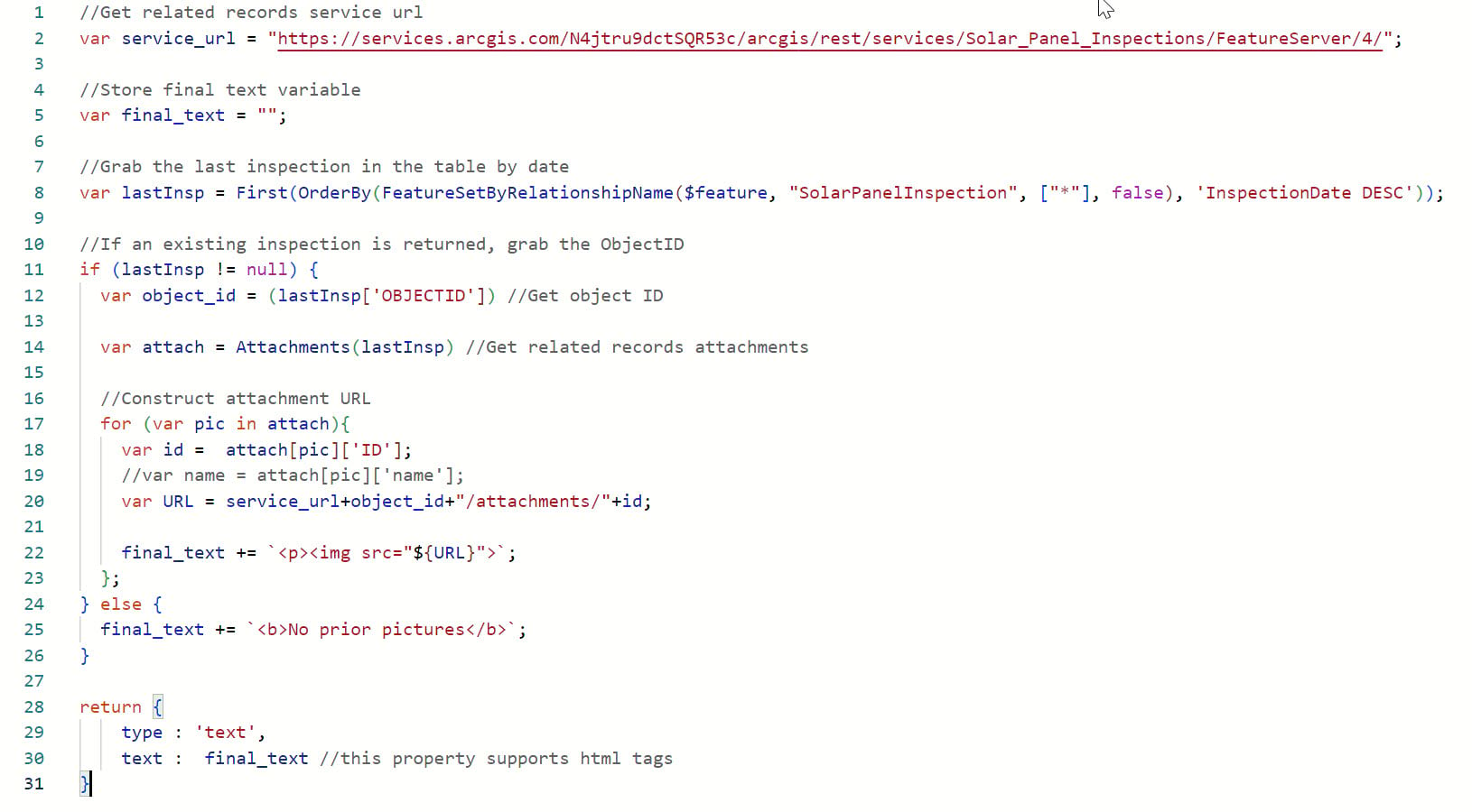
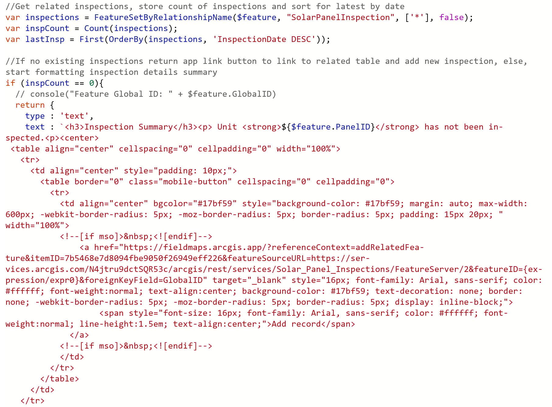
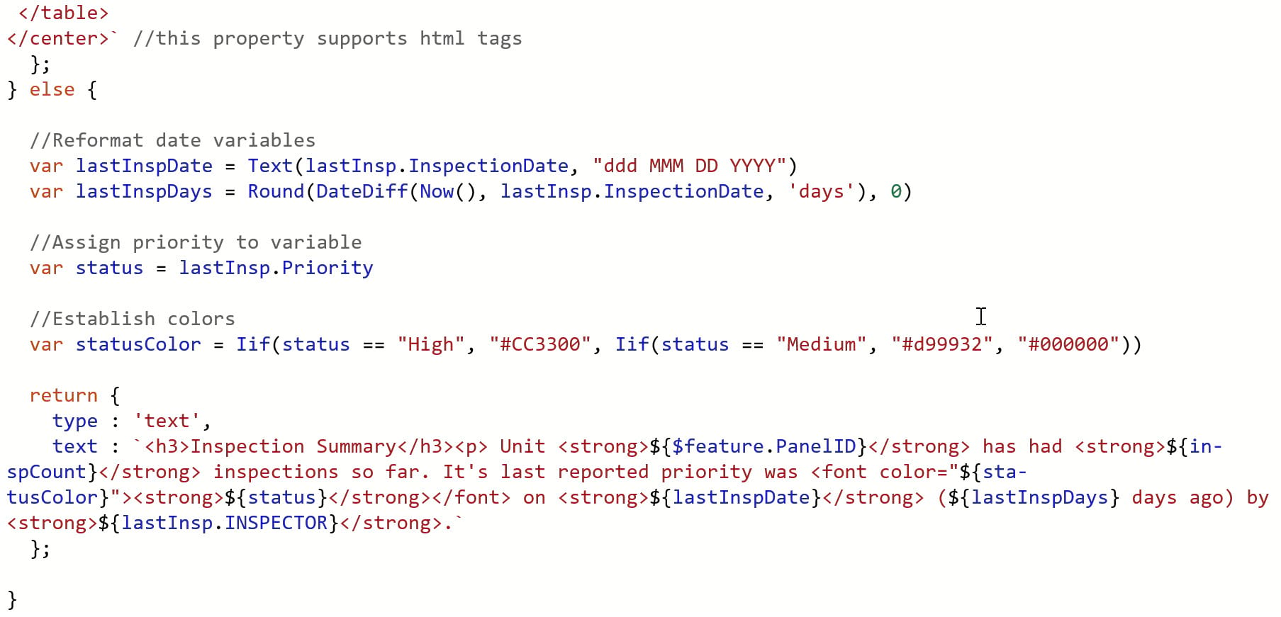
QUESTION: Can the Arcade expression for the pop-ups be provided so we can add it to our maps? This was during Colin’s presentation.
ANSWER: Yes, here are the Arcade expressions used by Colin in the webinar:
Globalid Format

Fetch last attach pop-up
Last Inspection details
QUESTION: Is there a way to alter the size of buffer depending on a specific value of an attribute? Or can you only set a standard buffer?
ANSWER: If you are using Arcade to set the size of a buffer for a field calculation, you can add a field where a user can set the size and then have this as part of the calculation.
QUESTION: Is there an Arcade expression to pull the acreage of a polygon created in Field Maps?
ANSWER: To find the area of a polygon, you can use the AreaGeodetic() function. This function is limited to geometries in Web Mercator or WGS84, so if your data is in another spatial reference, you must use the Area() function instead. You must create an attribute field where you will run this calculation in your form.
QUESTION: It looked like the last inspection Arcade script in the webinar was connecting to a service. If you are offline, will that work for Field Maps?
ANSWER: If an Arcade expression is referencing another layer, as long as that layer is also available in the offline map, the expression will run.
Integration
QUESTION: Will completing an inspection close an existing work order?
ANSWER: This depends on the workflow that you have set up. You can set up webhooks to update your work order once an inspection is closed, assuming there is a webhook that works with the software you are using.
QUESTION: Can you share the GitHub repository for scripts you can use with Field Maps?
ANSWER: Yes, you can find scripts at the field-maps-scripts repository.
QUESTION: How are PDF reports being generated from ArcGIS Online or is this from the create report process in ArcGIS Pro?
ANSWER: The reports that were shown by Haley were generated by Survey123; however, you can also create reports in ArcGIS Pro as well. The Get Started with Survey123 reports blog article can help you.
The following are more Q&A blogs from other ArcGIS Field Maps webinars:
- Create Intuitive Field Workflows with ArcGIS Field Maps and Arcade Webinar Q&A
- Seamless Migration to ArcGIS Field Maps Q&A
- Field Maps: Q&A for Efficiency Webinar on March 15, 2023
If your question wasn’t answered here or you have subsequent questions, share these on Esri Community. If there are any future webinar topics you’re interested in, you can suggest those in the Field Maps Webinar Topics survey.


Article Discussion: