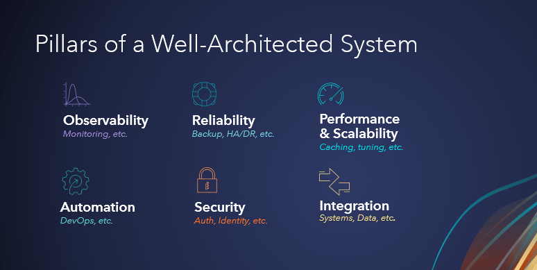
During day two of the Developer Summit plenary, Jay Theodore and others lead us through an exciting series of demonstrations, showcasing ArcGIS as a well-architected and foundational enterprise system that is composed of many products and capabilities. Throughout this section, see how ArcGIS is built on a foundation of six pillars and a well-architected framework with recommended patterns and best practices.

ArcGIS Well-Architected Framework
In the first demonstration, Witt Mathot provides a tour of the ArcGIS Well-Architected Framework and Architecture Center, a new resource intended for organizations to use as they design, deploy, and operate ArcGIS as enterprise systems.
The next presenters will share applications of some of the pillars of a well-architected system mentioned by Witt.

- Learn more by reading the companion blog here: A tour of the ArcGIS Well-Architected Framework
Resiliency in a world of chaos
In this demonstration, Bill and Chris show us how the observability and reliability pillars are upheld in ArcGIS Enterprise on Kubernetes, even when faced with critical failures.
- Learn more by reading the companion blog here: Observability and reliability in ArcGIS Enterprise on Kubernetes
Scalable raster analytics on Kubernetes
Jay then highlights the performance and scalability of ArcGIS Enterprise on Kubernetes. When working with massive raster data, the processing time for certain workflows could take days to complete. With ArcGIS Enterprise on Kubernetes, the settings of the raster processing services can be adjusted to better support your organization.
In Jay’s example, tuning up the number of pods and resources for each pod reduces the analysis processing time from about 97 hours to just under an hour.
Manage your organization using ArcGIS API for Python
Next, Manushi demonstrates compelling automation workflows that help you monitor and manage your ArcGIS organization. She uses ArcGIS Notebooks and the ArcGIS Python API to understand the usage history of organization members, assess credits consumed by members, monitor resource metrics of Premium Feature Data Stores, and more.
- Learn more by reading the companion blog here: Manage your organization using ArcGIS API for Python
Business system integration with SOIs and Salesforce
Shreyas then features the power the of an ArcGIS system integration with Salesforce. He demonstrates how a solar power installation company maintains its existing and prospective customer data in Salesforce using integrated workflows with ArcGIS Pro and ArcGIS Enterprise.
- Learn more by reading the companion blog here: Business system integration with SOIs and Salesforce
Data integration using ArcGIS Data Pipelines
Next, Max Payson highlights a data integration scenario in ArcGIS. He demonstrates how you can integrate and enhance datasets from multiple sources in ArcGIS Online using ArcGIS Data Pipelines.
- Learn more by reading the companion blog here: ArcGIS Data Pipelines


Commenting is not enabled for this article.