To address the demands of rapid urban development happening around the world, urban planners and designers must develop increasingly complex master plans to keep improving cities. If they succeed and manage to create great master plans, our cities will continue to evolve over the decades and transform according to citizens’ needs in the future.
What defines a great master plan?
In essence, a truly great master plan requires both functionality and aesthetic appeal; a successful master plan proposal requires the perfect balance between function and form comprising of both:
- a robust, functional concept that meets the requirements outlined by policymakers, and
- realistic architectural detail impressions and compelling visuals that convince people of the envisioned livability on a human scale.
Why is it challenging to create such a master plan?
Creating a great master plan is a challenging process because of the many actors and software tools required to solve the highly complex urban design problems involved. Typically, a team of urban planners first define goals, regulations, functions, typologies, and massing of a master plan, and then it may be refined by a team of urban designers (architects) and/or visualizers (ranging from watercolor painters to 3D rendering artists).
There is also one important aspect that neither the planner nor the designer can neglect: the geography. Understanding the location and surroundings of a master plan, either at plan-scale or city-scale, is crucial to making the right functional and aesthetic decisions about what is being proposed.
Imagine if this could all be accomplished by one software system?
Well, it can! Within the ArcGIS platform we have two focused applications, ArcGIS Urban and ArcGIS CityEngine. The combination of these two tools bring together the unique master planning capabilities of Urban with the “magical” generative urban design capabilities of CityEngine. This integration merges urban planning and design workflows that should always be executed together. It empowers a city planner to envision a master plan down to the human scale on the ground level.
ArcGIS empowers planners and designers to shape the cities of tomorrow
Let’s take a closer look.
In this article, we provide guidelines on how planners in local government organizations can transform their master plans created in Urban into vibrant urban landscapes using CityEngine, with minimal effort and maximum control. We describe how plans from Urban can be seamlessly opened and refined in CityEngine. Its tight integration into the Urban platform allows city planners to visualize 3D buildings, facade details, streetscapes, and greenspaces early in the master planning process, achieving unprecedented quality at minimal cost.
Note that we assume that the reader is familiar with the fundamental concepts of Urban and CityEngine. For more information on both tools, explore learning resources for Urban and CityEngine.
Let’s get started:
1. Open Plan from Urban in CityEngine
Before you can start, you need to login to CityEngine with an account that has access to Plans from Urban. If you don’t have this, then go to the ArcGIS Urban site and get a trial account. (If you currently have neither product, you can trial both through the ArcGIS CityEngine 21-day trial). In the following example, we use the Boston Plan that is freely available for trial users.
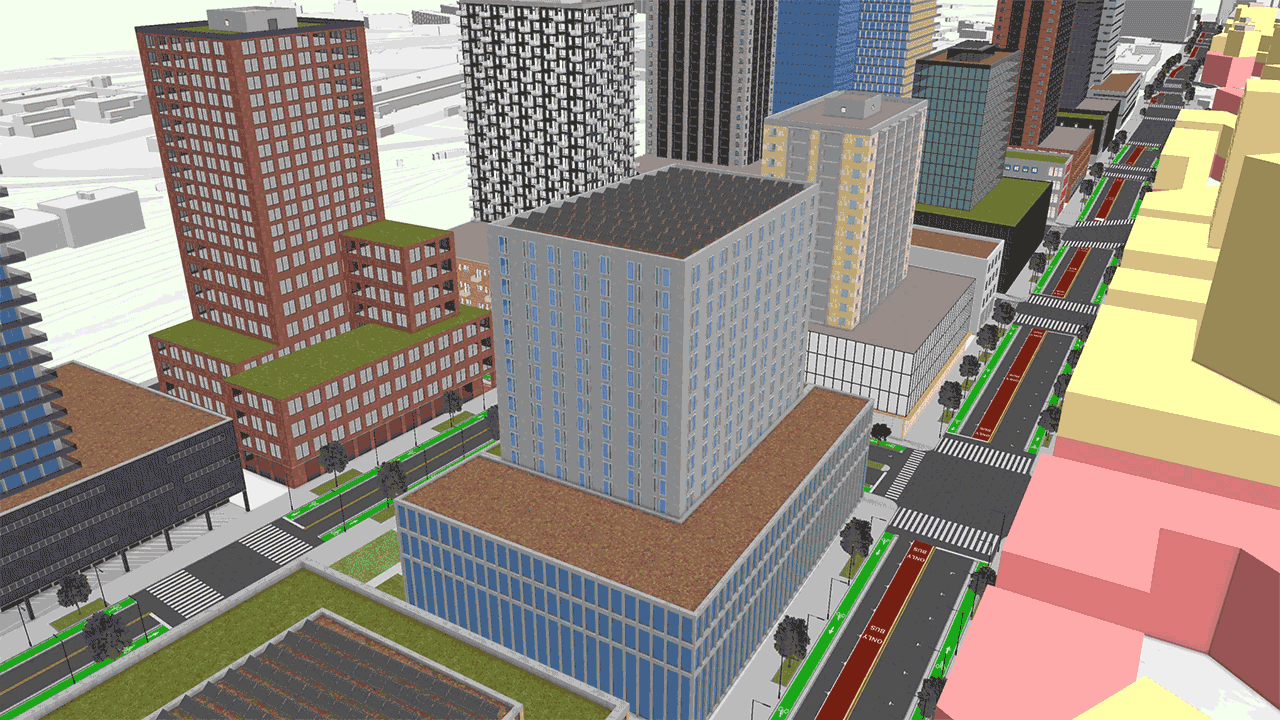
To illustrate this Urban-CityEngine integration workflow, we’ll use the well-known Boston Dot. Ave. example Plan.
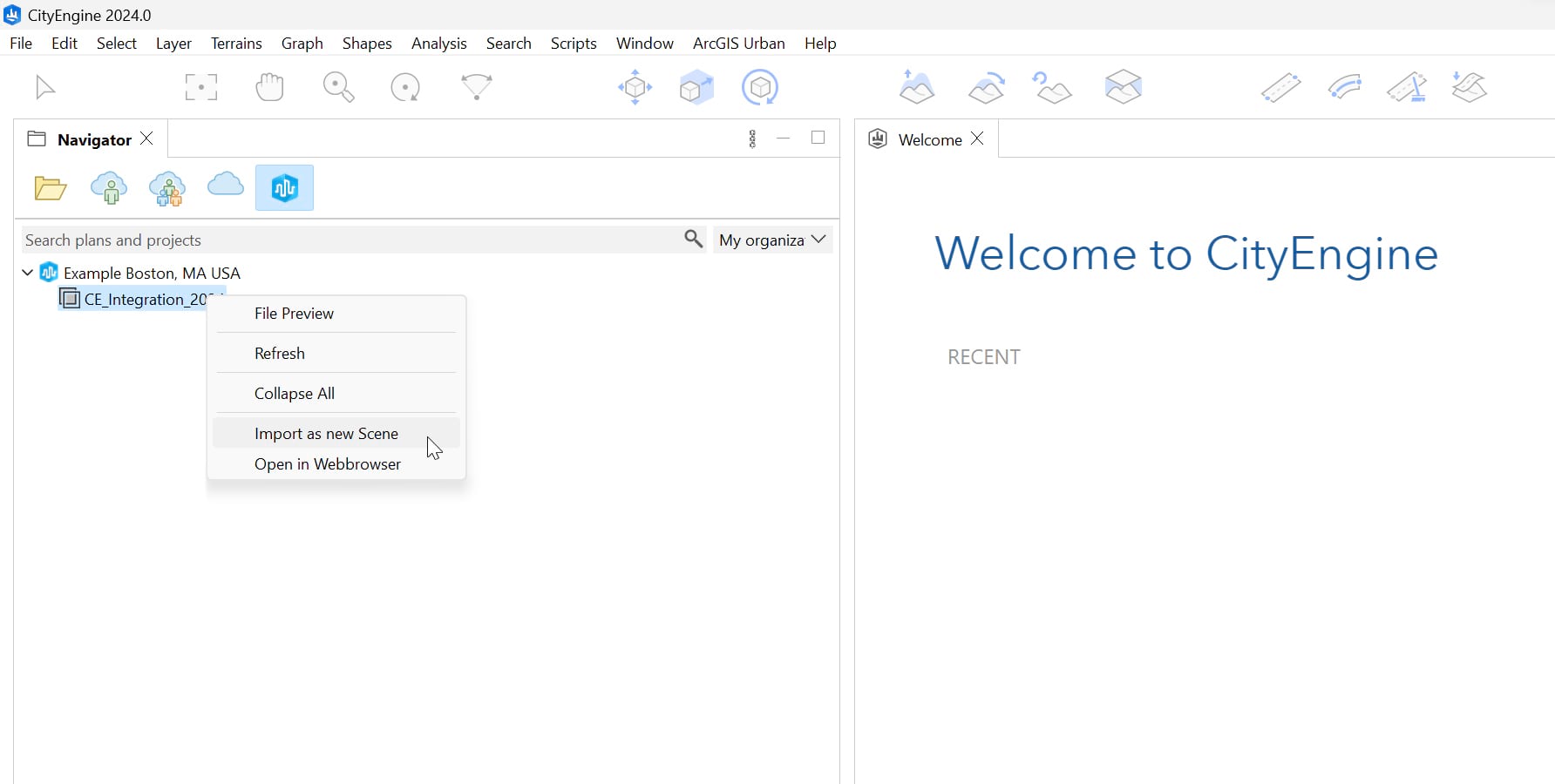
Once logged in to CityEngine, we can connect to the Urban items through the ArcGIS Urban tab in the Navigator window, which displays all the Plans from ArcGIS Urban that you have access to.
Right-click on the Plan we want to integrate and select “Import as new Scene”:
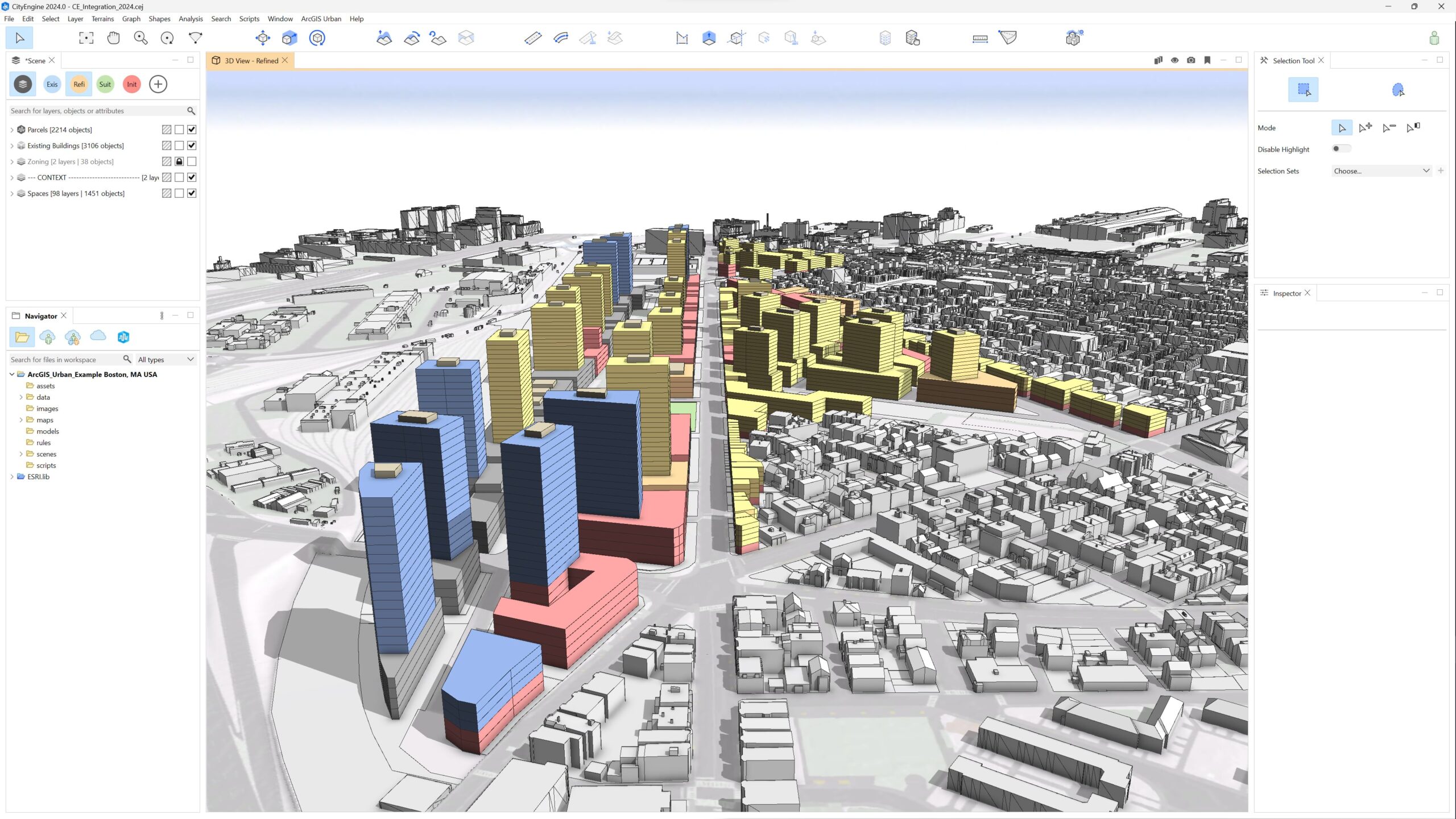
Once the import is finished, the CityEngine scene will contain the following (group) layers:
- Spaces
Per building, a layer with multiple Shapes. A Shape is typically a floor plate where its intended usage (“Space Use Type”) is known. Meaning, in CityEngine a “Shape” is created out of every “Space” in Urban – regardless of whether the Space has been generated procedurally or manually (see special note)
- Parcels
Imported as flat shapes aligned to the original terrain - Zoning polygons
These are needed internally by CityEngine to get the Zoning information on the parcels - Existing Buildings
Buildings that have not been demolished inside the Study Area - Context
- Terrain (automatically aligned to parcel shapes)
- Buildings (surrounding buildings outside the Study Area)
On top of that, the Scenarios defined in Urban will also be present in CityEngine.
SPECIAL NOTE:
- In CityEngine, a Shape is created regardless of how it was created in Urban, which can be ‘procedurally generated Spaces’ or ‘manually created custom Spaces’
- You can apply the Urban Rule on the Parcels layer, etc.
2. Add 3D streets and open spaces
CityEngine has unique capabilities to create 3D streetscapes and open spaces.
Street networks can easily be created using the Street Creation Tools. Then we recommend that you apply the CGA rule from the “Complete Streets” example project (can be downloaded in CityEngine under “Help – Download Tutorials and Examples”). The rule provides controls to design each type of street in 3D.
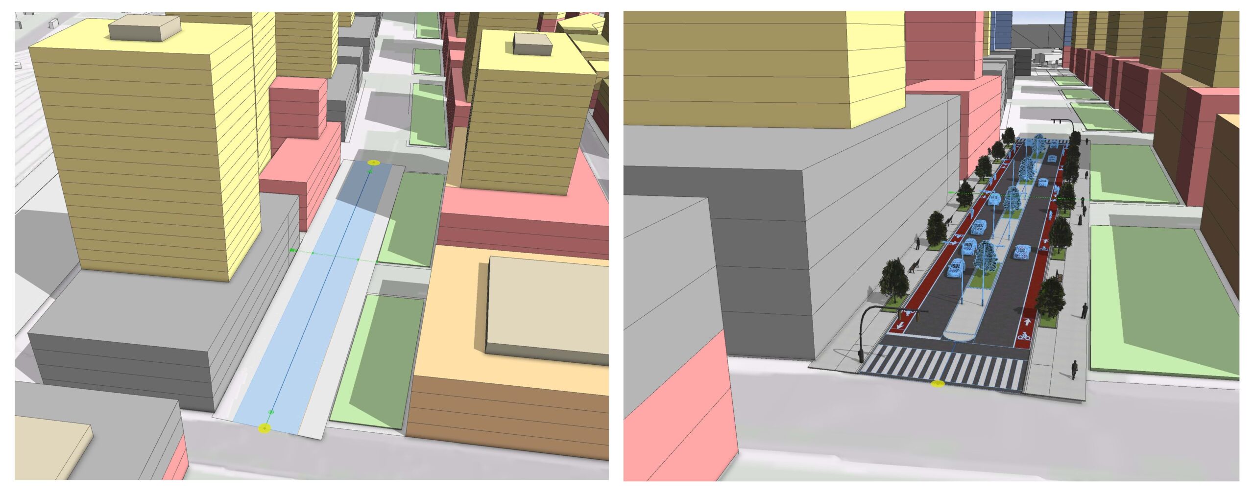
Potential adjustments to the terrain layer may be also carried out in parallel with street creation. CityEngine recently improved its terrain editing tools to give you even more control over your terrain.
Green spaces around buildings or in parks can also be shaped using the rules included in Esri.lib.
SPECIAL NOTE:
To view the resulting 3D streets in Urban, you can export them in CityEngine as an SLPK, publish them as a 3D Object Scene Layer, and open them in Urban via the Design Context Layers functionality.
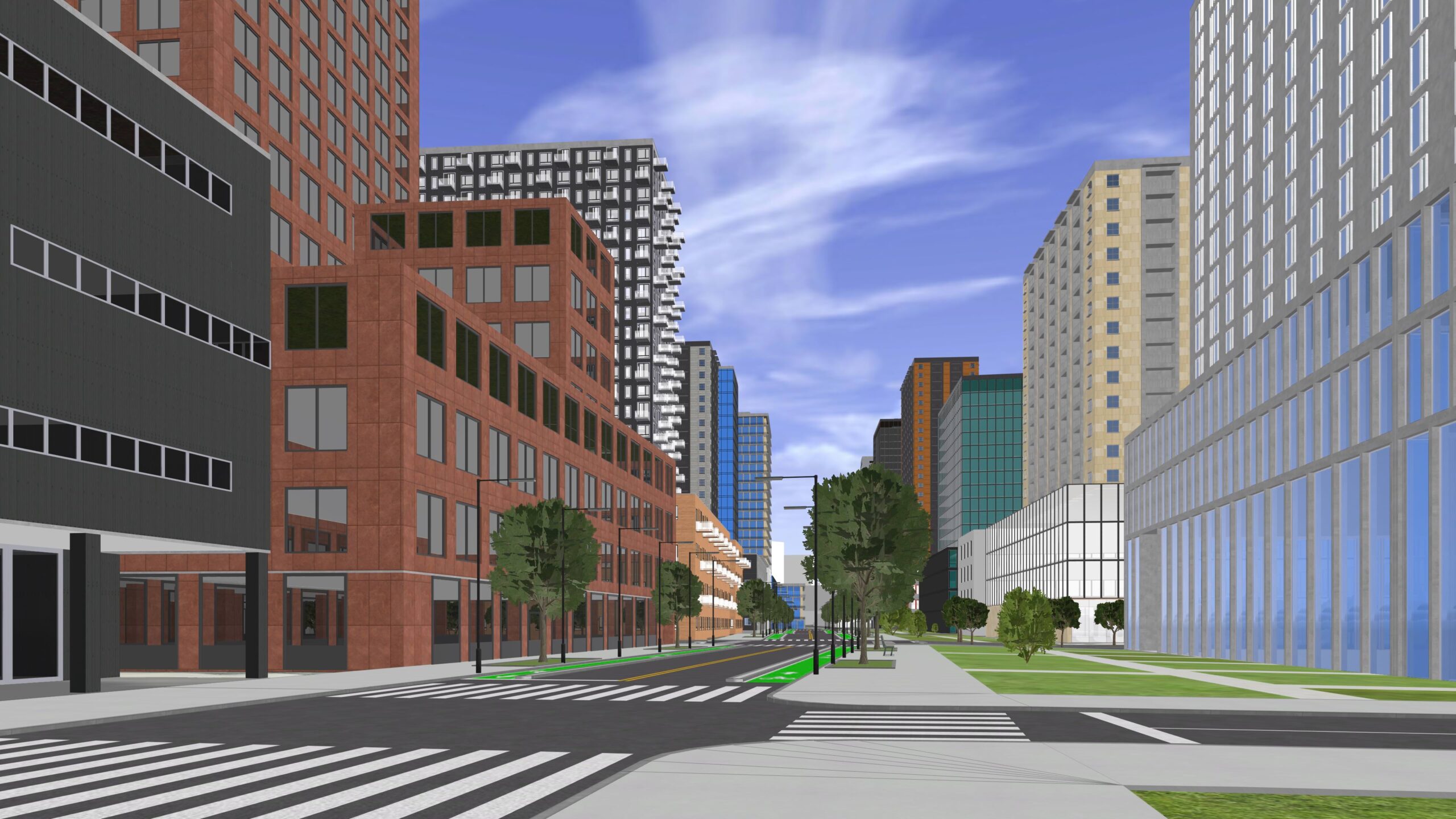
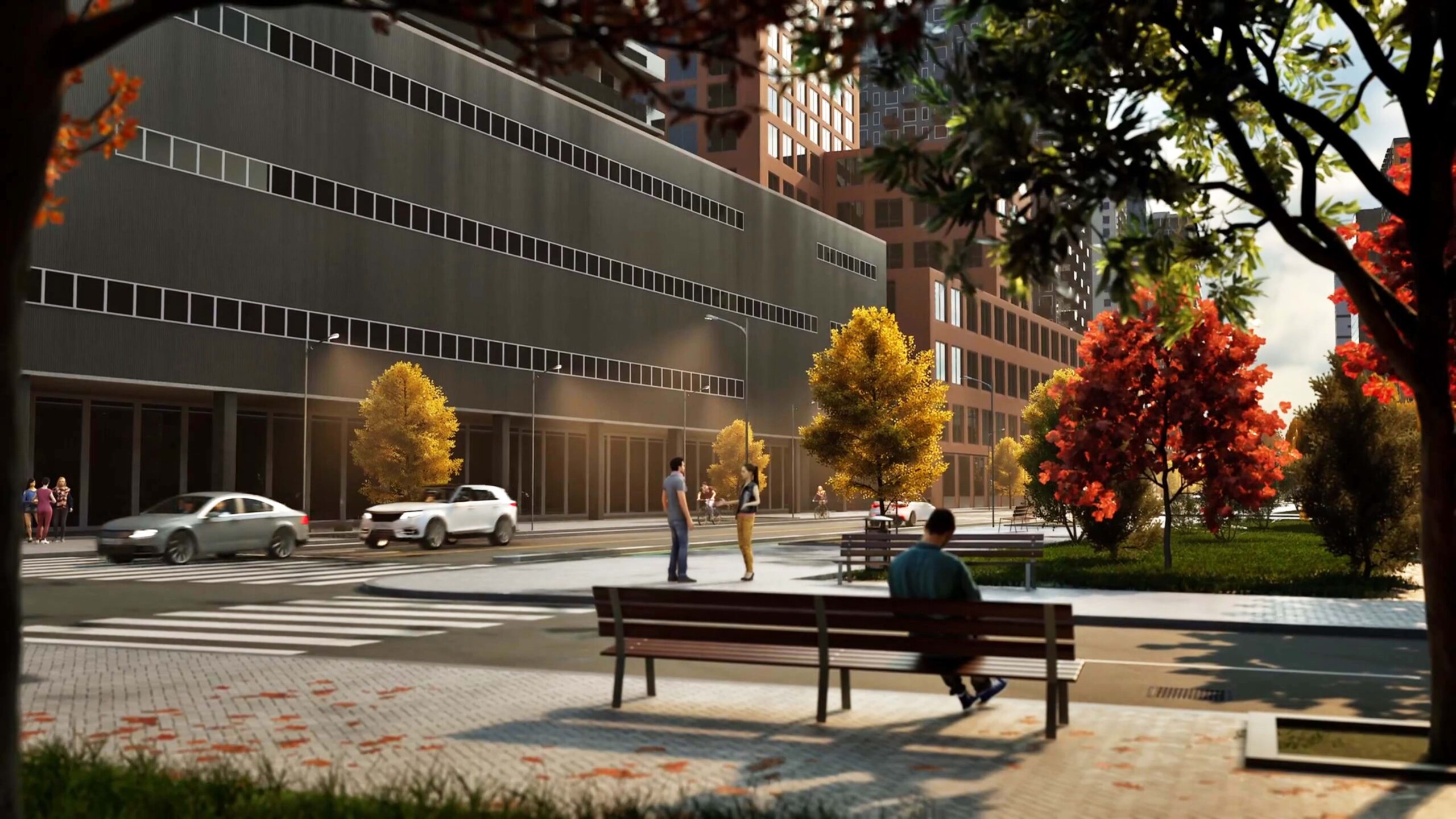
3. Generate procedural facades
Now it’s time to give your massing models some personality — and to do that, the official VCGA (Visual CGA) Playground Example is the best place to start. This is same example that we use here, and it’s a great source of rules directly available from the CityEngine Help menu.
In the Boston Dot. Ave. Scene you will find a good number of façade rules that we can apply immediately to Custom and/or Procedural Spaces. This way, we can turn their exterior appearance into detailed buildings that reflect a variety of uses and architectural styles with very little effort.

You can watch a short demonstration below to quickly learn how they work:
The rule catalog expands with every new release, so over time you’ll be able to bring your designs to life more and more accurately. The goal is to have a great choice of out-of-the-box façade rules to easily transform simple massing volumes into realistic buildings that convey the mood and feel of a very specific urban environment.
Of course, advanced users may want to customize the available rules or even create their own for tailored solutions.
Keep in mind:
- Running “Get changes from Urban” for a specific scenario where we worked out our facades will revert our whole scenario to the original state. Creating a copy of the scenario in CityEngine to work out our detailed version is always good practice to ensure that our design is preserved, even if we retrieve changes from Urban.
4. Refine the building mass models
As we continue applying façade designs on our buildings, it’s important to mention that floorplate shapes can be edited at any time. This way, the original spaces from Urban can be modified in CityEngine to refine our original mass models, or test new ideas if needed.
Keep in mind:
- Floorplates can be edited in CityEngine, but they won’t update as Spaces in Urban. Space integration is currently unidirectional.
5. Render the urban design
To bring our scene to the next level, we can export it into Twinmotion to create compelling visuals and animations.
Once we’re happy with our façade designs, streets and terrains in CityEngine, the whole scene can be easily exported as a Datasmith file format and opened in Twinmotion. We can benefit from this powerful platform and replace assets and materials with their libraries, so our urban concepts really shine in both static and video presentations.
Additional resources
- If you want to learn more about how CityEngine and Twinmotion work together, check out this article covering the step by step workflow in a concise and efficient way.
- For a deeper, more technical look at masterplan design, take a look at this article, Masterplan Design with CityEngine and ArcGIS Urban.
- To get started with Visual CGA, see this playlist or read this tutorial.
Building better cities
Architectural visualization is a fundamental part of urban master plans — not only as a tool to test our designs, but more importantly to communicate the kind of atmosphere we want to create.
Taking advantage of the ArcGIS Urban Suite to use both Urban and CityEngine in combination, this goal can be achieved with a minimal amount of work while also allowing a high degree of control.
We hope this article will inspire you to try these features and start improving your Plans in a very efficient way.
Try the Urban Suite via the ArcGIS CityEngine 21-day free trial (which includes an ArcGIS Urban trial), or purchase online.


Article Discussion: