ArcGIS Pro 3.2/Enterprise 11.2 represents the 8th release of the ArcGIS Parcel Fabric. Although the version of Parcel fabric has not changed since ArcGIS Pro 2.9/Enterprise 10.9.1, the parcel fabric team has continued to add new functionality and quality of life enhancements. This blog will cover the highlights of this release of the ArcGIS Parcel Fabric.
ArcGIS Parcel Fabric
The ArcGIS Parcel Fabric, first released in July 2019, continues to improve, and gain functionality. ArcGIS Pro 3.2/Enterprise 11.2 represents the 8th release of the ArcGIS Parcel Fabric. Some of the functionality has been on our roadmap, others are enhancements that have come from yourself and the market.
Simplified Licensing
When you deploy the ArcGIS Parcel Fabric with ArcGIS Enterprise, the ArcGIS Parcel Fabric is licensed through user types and the ArcGIS Parcel Fabric user type extension. Beginning with ArcGIS Pro 3.2 and Enterprise 11.2 a new user type extension has been introduced. With ArcGIS Enterprise 11.2, the parcel fabric user type extension is replaced by the Advanced Editing user type extension. The new Advanced Editing user type extension enables parcel fabric functionality, in addition to versioning, validation and editing geodatabase topology. If you are deploying the ArcGIS Parcel Fabric with a file or a mobile geodatabase, this change does not affect you.
Depicting Parcel Lineage
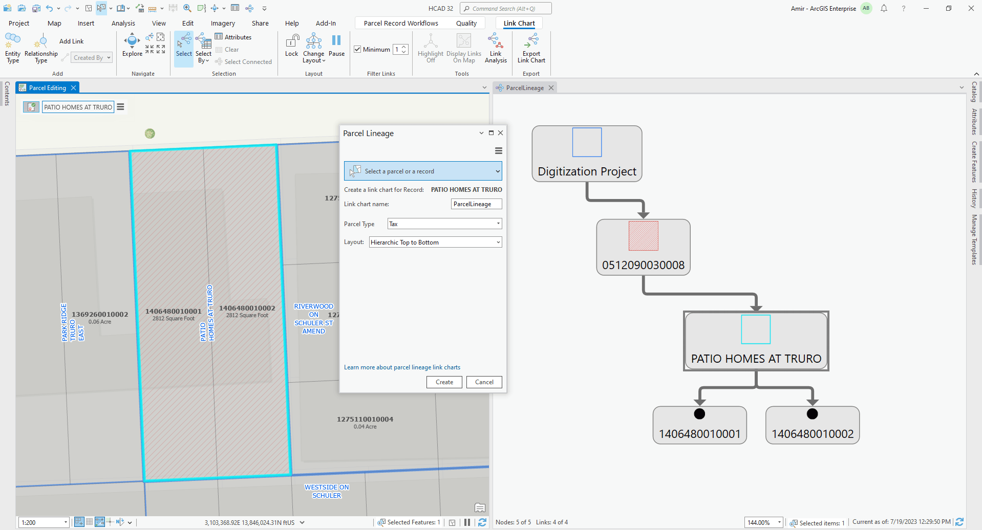
The ArcMap Parcel Fabric created history from parcel transactions. Beginning with the ArcGIS Parcel Fabric, not only do we keep track of historical parcels, but we keep track of the records that created or retired a set of parcels. With the ArcGIS Pro 3.2 release, you will not only be able to visualize historical parcels, but you will also be able to visualize the parcel lineage through link charts. Link charts provide ways to visualize relationships between entities in your data. In the parcel fabric, parcels and records are considered entities. This functionality will help answer the questions:
- Which record created this parcel?
- Which record retired this parcel?
- How many parcels did this record create/retire?
- Which parcel types did this record impact?
Offline Parcel Fabric
ArcGIS Pro 3.2 also brings the ability to take parcel data from your feature service for offline use. This functionality will assist clients that have intermittent internet connection between offices or need to perform edits without a network connection.
A typical workflow would be zoom to a work area, download the map, perform your edits, then sync your changes next time you connect to the network. All features within the map extent will be exported offline. The export includes the full ArcGIS Parcel Fabric data model including multi-part parcels, geodatabase topology, and attribute rules.

Automation Enhancements
Many of the organizations that have implemented the ArcGIS Parcel Fabric have expressed a desire to automate parcel maintenance functions. To satisfy their requests, some of the functionality available only from the toolbars has been made into geoprocessing tools.
Delete Parcel Geoprocessing tool
This tool will delete the selected parcels from the input parcel fabric. The tool works similarly to the Delete Parcels tool in that it will remove parcel polygon(s), and will remove lines and points associated to the selected parcels as long as they are not shared with other parcels.
Create Parcel Seeds Geoprocessing tool
When building parcels from lines, parcel seeds are used. A parcel seed is the initial state, or seed state, of a parcel. A parcel seed indicates to the build process that a parcel can be built from the lines enclosing the seed. Often, these lines may be imported from another format such as a CAD file. Users have requested the ability to programmatically create the seeds from a model or through a script. The Create Parcel Seeds geoprocessing tool available with ArcGIS Pro 3.2 can be used to help automate this process.
Active Record Properties exposed through Python
Users have also requested the ability to interact with the record properties programmatically. They have requested functionality such as the ability to determine the active record, the ability to set an active record, or toggle the visibility of features belonging to a record. Beginning with ArcGIS Pro 3.2, the ability to interact and persist record information has been added to the Esri Cartographic Information Model (CIM) and can be accessed via Python.
Export Parcel Records Features – Before and After maps
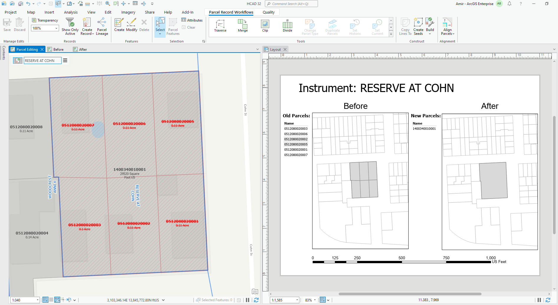
A common workflow among many land records clients is to generate before and after maps to communicate the changes that have occurred on a land parcel. These are maps that are generated for historical purposes to show the land parcel before any edits occurred and the final parcel configuration after the edits. They may be attached to the parent account in the Computer Aided Mass Appraisal (CAMA) system or distributed to different departments to communicate changes.
New at ArcGIS Pro 3.2 is a geoprocessing tool named Export Parcel Record Features. With this tool the user selects a record and it will export the parcel record geometry, and all the parcel polygons, lines, connection lines, and points, that were created and/or retired by the selected record. These exported features can then be added to a map used to generate a layout depicting parcel lineage. A status field is added to the exported data to indicate whether the feature was created by the selected record, retired by the selected record, or both.
Additional Quality of Life Enhancements
In addition to the new functionality introduced with ArcGIS Pro 3.2, there have been enhancements to existing parcel fabric functionality.
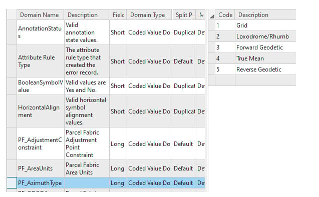
The Least Squares Adjustment (LSA) tool has been enhanced to support new direction types. The newly supported direction types, such as rhumb and geodetic, are used for COGO calculations on the earth’s ellipsoid surface.
The Explode tool has been enhanced to become parcel aware. You can separate, or explode, multipart parcels into individual parcels in the parcel fabric. Exploding multipart parcels can occur in workflows in which multiple parcels under a single ownership are sold to different owners. The explode tool has been enhanced to support the tracking of parcel history and lineage.
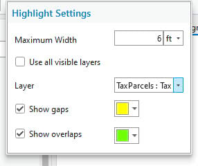
The Highlight gaps and overlaps tool has been enhanced based upon feedback from the user community. Clients have asked for the ability to toggle either gaps or overlaps as well as the ability to check for gaps and overlaps between layers. The tool has been enhanced to detect overlaps and gaps between visible layers, providing the editor with additional control when performing data quality analysis.
Learn More
These are just some of the new features available to parcel editors with the ArcGIS Pro 3.2 release. You can learn more by joining us for our “What’s new – Parcel Fabric@ArcGIS Pro 3.2” parcel fabric meet-up on November 21, 2023 or by watching the video recording on our ArcGIS Parcel Fabric Community Site.
Is there functionality that you would like to see added to the ArcGIS Parcel Fabric? Submit yours or up-vote a colleague’s idea(s) to the ArcGIS Parcel Fabric Ideas page.


Article Discussion: