The pre-enumeration phase of a national census is a time of extensive planning and preparation. A key activity is to divide the work up into small areas of land, known as Enumeration Areas (EAs), sometime also known as Enumeration Districts (EDs), and to produce accurate maps of these EAs for use in the census enumeration process.
EAs are the smallest statistical sample unit in a national census and are usually defined according to the number of households they contain. This number usually aligns with the number of households that a single staff member (enumerator) can visit and interview during the census enumeration period. Therefore, urban EAs usually have more households than rural EAs, as it’s quicker to move between dwellings when they are closer together. The boundaries of an EA typically follow physical features (such as roads, rivers and fence lines), so that staff in the field can easily identify the limits of their area of interest.
The UN recommends each nation carries out a national census at least once every ten years. Most countries already have some form of digital EA map showing their boundaries and identification numbers. However, as people move and landscapes change over the years, the total number of households in each EA needs to be recounted and the boundaries checked ahead of each national census.
To achieve this, a pre-enumeration cartographic survey can take place 1-2 years ahead of a national census with the following goals:
- Identify new buildings that did not exist in the last census
- Physically check all buildings and key infrastructure, and categorize their use (e.g., commercial, residential, industrial)
- Identify all residential buildings and obtain an accurate count of households within
- Define or adjust EA boundaries
- Locate or check features that define EA boundaries
Understandably, a pre-enumeration project is critical and extensive. The data collected and verified in the pre-enumeration phase will be the basis for all work to follow and helps to ensure the accuracy of the resultant count. . For this reason, we have created a new learn lesson Conduct a pre-enumeration survey to demonstrate how a pre-enumeration cartographic survey might be conducted.
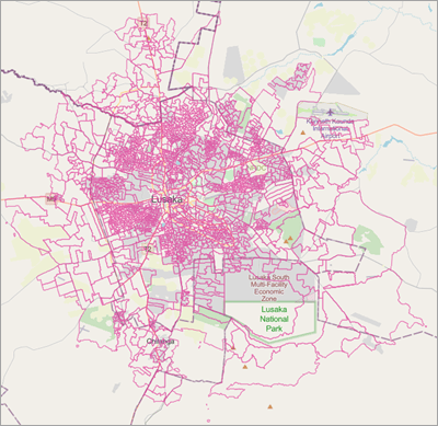
Using Survey123, the lesson demonstrates how to start with existing EAs and create a survey that can be used to update these EAs for the next census.
It also makes use of the following key features of Survey123 that help to optimize the pre-enumeration workflow:
- Prepare a map of existing enumeration boundaries that can be used both online and offline
- Create a survey that uses the inbox to help fieldworkers plan their work based on record completion status
- How to create polygon features in a survey
These are features that are valuable to lots of different types of projects and are not unique to a pre-enumeration survey. Anyone can use this lesson to learn more about these specific features.
Prepare an offline map
Using a feature layer populated with sample data, you will create an online webmap that you will reference in your pre-enumeration survey. This will give you a customized background map in Survey123 upon which to capture new records. However, to ensure the survey can be used offline the lesson also shows you the additional steps needed to take that map offline. These steps are:
- Enable sync on the feature layer
- Enable offline mode on the webmap
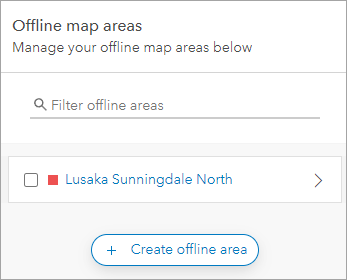
- Create offline areas in the webmap
With offline areas in the webmap, the person using the survey will have the option to download these areas ready for when they go offline.
Use the inbox to identify record completion status
The pre-enumeration survey scenario is a great example of fieldwork that is completed by a very large number of fieldworkers and has a need for records to be verified by office staff and possibly returned to the field worker.
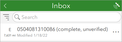
Whilst completing the survey, fieldworkers have the option to check a box to say they are complete. With this check made, the record will be identified in their inbox as ‘complete’. Office staff checking records also have an option to check a box that say the record is ‘verified’, and this too is shown in the inbox.
This lesson demonstrates how to use these ‘complete’ and ‘verified’ statuses in the inbox to order records for viewing. Taking this a step further in your own surveys, consider adding an Inbox query to only show records that meet a desired criteria. For example verification_status=’Returned for field checking’ would only show records in the inbox that the fieldworker needs to check.
Create polygon features
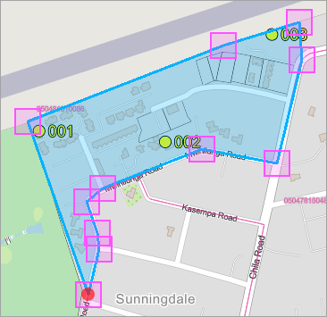
Polygons that represent existing enumeration boundaries are an important starting point for a pre-enumeration survey, but it is essential that these boundaries can be re-drawn to match the updated household information. When new buildings are added, a boundary may need to be made smaller to accommodate the denser population.
New boundaries can be drawn directly on a map in the survey, using the existing boundaries and building points as a guide.
Of course, by its name alone – Conduct a pre-enumeration survey – it’s clear that this lesson demonstrates only the beginning of what is needed for population census project. The census form itself is often a primary focus in census projects and we have a number of lessons that can help you prepare to create your census form. To learn more see the Using GIS for Census Workflows section of the Official Statistics Modernization curriculum.



Article Discussion: