You really, really wanted to land at the Esri User Conference (Esri UC) this year, but no such luck.
No worries. The conference will migrate back to San Diego, California, in 2016—albeit a little earlier in the summer than usual—because the Major League Baseball All-Star Game will be hosted there during the second week of July. So save the dates: June 27–July 1.
It’s almost impossible to totally recapture the spirit of personally interacting with your peers; eyeing hundreds of beautiful, informative maps; watching live tech demos; and trying out GIS apps. But Esri’s video team is posting videos of the keynote address, the technology demonstrations, and more, which will put you at the scene of the action. Esri photographers also took thousands of pictures, which they happily posted on Esri’s Flickr photo sharing site.
For a quick overview of the opening Plenary Session, keep reading:

- Enter the Era of Geographic Enlightenment. Esri president Jack Dangermond introduced the term geoenlightenment during introductory remarks at the Esri UC Plenary Session. What is geoenlightenment? Dangermond said it means understanding how things on our planet are interconnected and applying that knowledge to make the world a better place. “What we do here, affects there,” he said. Watch the video and read the article.
- Analyze Very Big Data with ArcGIS.Geoenlightenment will get a big boost from Esri’s Big Data GeoAnalytics extension for ArcGIS for Server, which is slated for release next year. Mansour Raad, senior software engineer for Esri, demonstrated how Big Data GeoAnalytics was used to analyze where to plant 87 varieties of corn hybrids sold by Beck’s Hybrids in Indiana based on soil type, a specific time window, and heat and soil moisture. This added up to 300 billion spatial and temporal calculations. “We did these calculations in 10 minutes. Pretty cool,” said Raad. Watch the demonstration.
- R You Ready? Esri just launched the R – ArcGIS Community on GitHub. The new initiative’s goal is to build a collaborative community for R and ArcGIS users. R is an open source programming language for statistical analysis. “Now R users can directly access all their organization’s GIS data, and ArcGIS users can directly integrate R into their geoprocessing workflows,” said Esri’s Steve Kopp. Watch Kopp’s presentation, Statistical Integration with R.

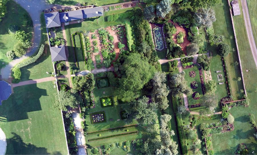
- Buzz Builds for Esri App for Drone Imagery.Esri’s Tony Mason previewed Esri’s new mapping app for drones, which he said “streamlines the processing of drone data.” Within 83 minutes of collecting still imagery of the Oatlands Historic House and Gardens in Leesburg, Virginia, with a drone, the raw data from a Secure Digital (SD) memory card was loaded, verified, processed, turned into a tile cache, and shared via an ArcGIS Online portal. “The app built a stunning mosaic from hundreds of images collected by the drone,” Mason said. “The imagery is so detailed, you can even see individual plants.” See how the imagery looks in ArcGIS.
- Get Ready for Vector Tiles! Esri’s Nate Bennett got the audience up to speed on the fast, responsive vector tiles. “Data is prerendered at various map scales, cut into tiles, then cached for quick delivery,” he told the crowd at the Esri UC, as he showed an example of vector map tiles on-screen. “This looks like a regular raster base mount. But it’s not. As the map rotates, watch the labels dynamically orient.” Very cool! Watch vector tiles in action.

- Mission Possible: The Role GIS Plays in the Fight against Ebola. Dr. Bruce Aylward from the World Health Organization (WHO) took the Esri audience behind the scenes of the battle to wipe Ebola off the map in West Africa. He credited GIS tools for everything from helping track the chains of virus transmission from one person to another to getting the food and medical support needed to the right locations. “This was a huge logistical effort, much of it guided by the kind of work that you do and by the kind of tools that have been developed through the GIS community,” Aylward said. Watch the video.
- Step into the AppStudio for ArcGIS. Esri’s Ismael Chivite, Sathya Prasad, and Elvin Slavik demonstrated how to create native apps for multiple platforms in a snap using the configurable application templates and other functionality in the new AppStudio for ArcGIS. Best of all, there’s no coding required. View the demonstrations.

- Swoon over ArcGIS Ready-to-Use Apps. Chivite introduced Esri’s ready-to-use ArcGIS apps in an entertaining app speed dating session, complete with an app rapper and a country crooner. All the apps are available today, so watch the video and then decide: Which app or apps do you want to use?
- See What’s Trending in Web GIS. Esri’s technology evangelist Bern Szukalski walked the audience through top trends in web GIS, including the establishment of portals for geospatial information, the growing amount of authoritative content that’s available, and easy-to-use analysis tools. Watch his demo.
- Applaud the Winners. Dangermond honored many organizations with awards for their fine work implementing GIS, including Irish Water, which won the Enterprise GIS Award; Abu Dhabi, which received the inaugural Esri Smart Government Award; and the National Audubon Society, which won the Esri President’s Award. The International Centre for Integrated Mountain Development (ICIMOD) also was presented the Esri Humanitarian GIS Award for helping to provide Nepal’s government with vital information that helped officials better respond to and recover from the devastating earthquakes in that country earlier this year.

