Some layers in your ArcGIS Online web map may continually update, such as a GeoRSS feed or a feature service that adds new information as workers in the field perform edits. When the map or layers are redrawn, this data refreshes.
But by using the refresh interval property on these layers (a new capability introduced in the latest ArcGIS Online update), you can force an automatic refresh at a specific time interval. These refreshes occur even while the map is open and idle and will synchronize the map anywhere it is accessed—via browsers, desktops, or devices.
Using the Refresh Interval
The US Geological Survey (USGS) publishes continually updated earthquake data in a variety of formats, including the Atom syndication.
Step One: Access the Feed
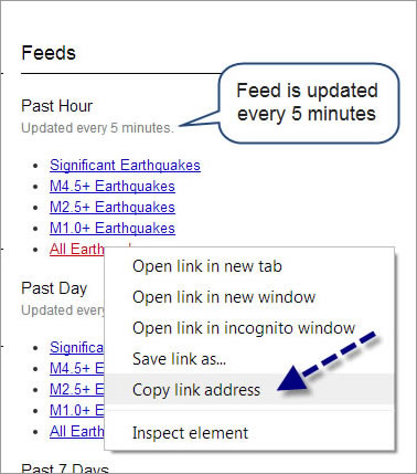
Open the USGS web page. Look in the upper-right portion of the page. You will see a list of available feeds that show earthquakes of various magnitudes in time periods that range from the past hour to the past 30 days.
In the Past Hour section, right-click All Earthquakes to show the option to copy the link. (Your choices will vary depending on your web browser.) Note that the update interval for Past Hour feeds is every five minutes:

Step Two: Add the Feed to Your Web Map
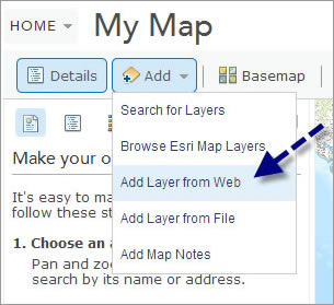
Open a new web map in ArcGIS Online and choose Add, then choose Add Layer from Web:

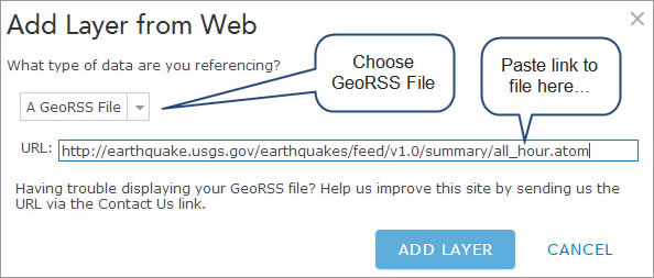
From the drop-down list, choose A GeoRSS File and paste the link you copied from the USGS website into the URL text box:

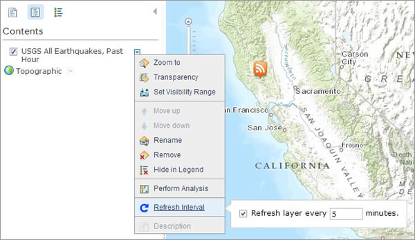
The map now displays earthquakes that have occurred over the last hour. Since the feed is updated every five minutes, set the refresh interval on the layer to match.
Click the arrow next to the layer name and choose Refresh Interval. Make sure the refresh box is checked, then enter your desired interval (in this case, 5 minutes). The interval must be expressed in minutes but can range from 0.1 (six seconds) to 1,440 (one day).
When you save the map, the layer properties persist and the layer will automatically refresh at the interval you specified. View the Sample web map.

For more information, read

