At the heart of the 2030 Agenda for Sustainable Development established by the United Nations (UN) is an ambitious collection of social and economic objectives known as Sustainable Development Goals (SDGs). These 17 goals include eradicating poverty, ending hunger, building infrastructure, and creating inclusive and sustainable cities while protecting land and conserving water. Referred to by the UN as “a shared blueprint for peace and prosperity for people and the planet,” these goals represent an enormous undertaking. It’s difficult to overstate their importance—and it can be just as difficult for individuals and organizations to know where to start when setting their sights on these objectives.
One of the many groups that aims to address the SDGs is the Metabolism of Cities Living Lab (MOC-LLAB), a sprawling, interdisciplinary organization hosted by San Diego State University’s (SDSU’s) Center for Human Dynamics in the Mobile Age that focuses on using data to localize SDGs. While much of the focus is on issues in the greater San Diego area, the lab also collaborates on projects around the world, and its international team includes both graduate and undergraduate students, university faculty, and NGOs.
Directed by Dr. Gabriela Fernandez, a professor in the university’s big data analytics master of science program, MOC-LLAB represents a collaboration between instructors, students, and other partners to bring sustainable development to vulnerable communities. GIS tools such as ArcGIS Dashboards and ArcGIS Survey123 are often critical to these projects, allowing students and project leaders to understand the communities they’re working with. The goal is to create targeted solutions to local problems through a global lens.

“My students have developed several different projects [to support] vulnerable communities such as children, indigenous communities, homeless [populations], and refugees,” said Fernandez.
MOC-LLAB projects range widely, from collecting information about college students’ takes on sustainability initiatives to developing tools that teach children about street safety to creating dashboards aimed at improving San Diego residents’ access to healthy food. No matter the scope, each project has two things in common. The first is a commitment to achieving specific SDGs on a local level. The second is that each project, although it represents an educational opportunity for SDSU students, also has a significant impact on the community outside the classroom.
In the Classroom and Beyond
In practice, localizing SDGs can mean tackling multiple, related issues at once.
“All the SDGs are in a way interconnected with one another,” said Fernandez. “In order to create awareness about poverty, you need to educate the public.” Eliminating poverty and providing quality education are SDGs 1 and 4, respectively.
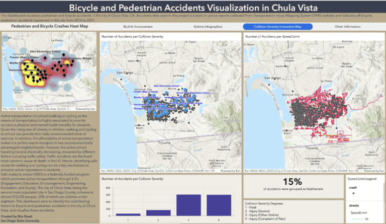
With the Safe Routes to School project, for instance, Bita Etaati used ArcGIS Pro and ArcGIS Dashboards to create a tool that would improve the safety of students walking or cycling to elementary schools in the city of Chula Vista. Etaati’s efforts were part of a larger transportation safety project called Safe-D, a collaboration between SDSU, Virginia Tech, and Texas A&M. Etaati’s 2023 project aimed to tackle SDGs 3, 9, and 11 (good health and well-being; industry, innovation, and infrastructure; and sustainable cities and communities). Etaati, a master of science in big data analytics student in the department of geography, collected data about pedestrian injury hotspots in the Chula Vista area to create an interactive dashboard that displays the frequency and severity of vehicle collisions. The dashboard is available to students and parents to increase awareness of unsafe intersections and to promote safer practices and routes when children walk or bike to school.
A virtual reality game called Kids 4 Safe Routes was also developed for this project by Fernandez and Andrick Mercado, an undergraduate student at SDSU. Intended to help elementary-aged children play out street safety scenarios in a virtual reality environment, the game has been deployed in Feaster Charter Elementary School, leading to a better understanding among kids of pedestrian safety practices. Etaati’s project is detailed in a story created with ArcGIS StoryMaps, which not only provides an overview of the project, but also a breakdown of how to use the dashboard.
Another standout project was developed in 2023 by Nasser Mohieddin. The project, known as We All Count, City of El Cajon, is a surveying effort aiming to gain more comprehensive insight into the large Iraqi refugee community of El Cajon, a city with the highest poverty rate in San Diego County.
According to the project website, “there is very limited information, services, and resources on refugees in the city, and current methods of data collection fail to acknowledge people of Middle Eastern descent independently.”
Using ArcGIS Survey123 to compile data about the area’s population, Mohieddin collected resident feedback into a dashboard created with ArcGIS Dashboards, which has already been used as a powerful tool to advocate for more targeted community needs—including a need for more information, such as a category for Middle Eastern and North African (MENA) individuals on future US Censuses.
In May 2024, largely because of the data-driven advocacy of Mohieddin’s project, the San Diego County Board of Supervisors added the MENA category to all county documentation, a decision that could go a long way toward bringing more targeted resources to the community.
The Impact of Localization through Education
Countless other MOC-LLAB projects have taken advantage of the university’s GIS tools to collect and communicate data to residents in San Diego and elsewhere, from initiatives aimed at helping unhoused populations access necessary resources to an analysis of water pollution in Imperial Beach along the US-Mexico international border. In multiple cases, these resources have empowered residents to take actions such as targeted beach cleanups and voucher systems for unhoused populations sponsored by local businesses.
In February, SDSU held an exhibit developed by BDA graduate student Thai Nguyen to showcase the work MOC-LLAB has undertaken in the community, in both English and Spanish, and to highlight the importance of SDGs not just for the world as a whole, but for the San Diego community. The exhibit included an SDG-focused mural and explanations of the SDGs and local issues MOC-LLAB has tackled. A corresponding virtual exhibit ensured that those unable to attend in person can still experience the exhibit online.

This exhibit was significant not only in drawing attention to the work MOC-LLAB has already undertaken, but also in educating the public about SDGs—in particular, how students, instructors, and other residents can bring these goals into their communities in a tangible, constructive way.
This is one of the major benefits to MOC-LLAB, as Fernandez sees it: the organization provides a GIS education that resonates far beyond the classroom.
“For me, it’s a great feeling to know that this project was not just an assignment,” said Fernandez. “It’s more than that. I want them to continue working on these projects beyond academia, beyond the university.”