Greenville, South Carolina, boasts a high level of walkability for a city its size. The city’s downtown area—with its abundant restaurants, greenways, shopping options, and vibrant workspaces—makes every turn of a corner feel like a thread in a tapestry of experiences, meticulously designed for residents and visitors.
That is, in part, because it was.
Greenville has been incorporating spatial data and analysis into development projects since the mid-1980s. As one of Esri’s earliest customers, Greenville has used GIS technology in many facets of its downtown revitalization initiatives. The results are widely touted as a city development success story by urban planning organizations, business and lifestyle publications, and other influential groups.
Planning and Development with GIS Technology
Now part of the city’s information technology department, Greenville’s GIS division supports many city departments, including public works; police; fire; parks, recreation and tourism; and—of course—planning and development.
GIS technical manager and map enthusiast Carmen Durham joined the city’s GIS division in 2003. Since then, she has witnessed firsthand how the city’s GIS products have evolved—from paper maps to web maps and apps to today’s dynamic digital dashboards.
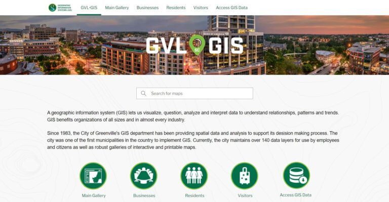
Durham’s team also manages the city’s hub site, created using ArcGIS Hub, where employees, businesses, and the public can access more than 140 GIS data layers and interactive maps and apps, including a popular app for finding parking garages and lots.
Advancing Skills with Esri Training
To help ensure that the city continues to reap the full benefits of GIS, Durham relies on training from Esri. Her team keeps its skills sharp and stays current with ArcGIS software capabilities using Esri Academy web courses, learning plans, and massive open online courses (MOOCs), as well as by attending in-depth instructor-led courses.

“I strongly recommend Esri training courses to [understand] the big picture,” Durham said, adding that she feels supported by a substantial annual training budget for the GIS division, which averages about $3,000 per employee per year.
It wasn’t always like this, however. Durham recalled a turning point for the GIS division when the city’s IT director attended the annual Esri User Conference. The in-person experience illuminated his understanding of the impact GIS technology can make, and he became invested in the value of maintaining up-to-date GIS skills, Durham said. The training budget, which is set by the IT director, allows for flexibility when selecting training opportunities—an advantage Durham is determined to maximize.
Now, part of the annual training budget is allocated to sending one or two GIS division employees to the Esri User Conference, which Durham calls “the best big-picture training there is” for GIS technology. She also invests in Esri Training Passes, which, she said, provide flexibility in fulfilling the city’s GIS training needs. Durham explained that the Esri Training Pass drastically reduces the administrative overhead required to train her team. By purchasing training days, only one invoice needs to be processed per year, instead of a separate invoice each time an employee takes a class.
“The Training Passes have also been a great option to manage remaining training funds at the end of the fiscal year,” Durham said. “For a city [with an approximate population] of 75,000 and seven GIS employees, this is a great benefit.”
Getting Recommendations for Training
To learn about new classes and plan for future training, Durham partners with Esri consultant Phillip Waldron, who provides training recommendations tailored to Durham’s team.
Waldron said Durham exemplifies a proactive approach to training across the city. “She collaborates closely with stakeholders to identify the most suitable training offerings,” he said, “ensuring that new and existing team members receive the best resources available.”
Durham encourages her team to regularly visit the Esri Academy website to find courses of interest. She also incorporates individualized training goals into employee performance reviews.
Training isn’t always planned much in advance, however, and Durham knows the importance of adapting as needed. When one of her team members finds a useful course or webinar, Durham often directs everyone else on the team to complete the same training.
Durham’s partnership with Waldron provides her with insight on ArcGIS training options that are in development. This helps her plan for new projects. For example, when she learned about ArcGIS Arcade and its ability to customize map labels and pop-ups and streamline data validation, Durham knew she wanted her team to leverage Arcade in their projects. With Waldron’s assistance, Greenville’s GIS team members were among the first to attend Esri’s instructor-led Arcade course when it launched in early 2024.
“They were immediately able to use what they learned, especially in ArcGIS Online,” Durham said.
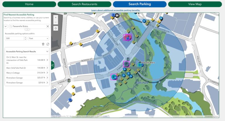
When a big GIS-based project is planned for Greenville, Durham said, she attends training herself. For example, the city’s GIS team needed to support an accessibility app with an ambitious release date for downtown visitors with disabilities. After attending Esri’s Building Web Apps with ArcGIS Experience Builder course, Durham created the AccessGVL web app, which helps users find key information to navigate downtown Greenville more easily. The app highlights optimal routes, parking locations, and restaurant details such as bathroom access.
“This course enabled me—a manager who has a ton of other responsibilities—to really refine and make that application what it is today. If I hadn’t taken the Experience Builder course, I wouldn’t have been able to finish that application in time,” she explained.
The GIS team met the project deadline, and the app has become a valuable and widely praised tool for visitors. In 2024, Greenville and the app were recognized at the Esri User Conference with a Special Achievement in GIS Award.

Mapping the Road Ahead
Greenville has become a great example of a small city that uses GIS technology to support businesses and enhance the quality of life for residents and visitors, and Waldron is impressed by the work that Durham and her team have accomplished.
“[Durham] is instrumental in positioning the city as a center of GIS excellence,” Waldron said. “Her commitment to continuous learning and professional development fosters a culture of growth and innovation.”
Looking forward, Durham expects more GIS projects that will support the city’s needs. She hopes to expand the city’s hub site to make it more user-friendly and include more in-depth information for businesses.
To accomplish these goals, training will again play an important role in preparing the team and filling knowledge gaps.
Durham also wants the team to dive even deeper into Arcade, which has proved useful for enhancing the city’s web maps.
“Everybody will be taking that course,” she predicted.
For more information about Greenville’s GIS program, contact Durham at cdurham@greenvillesc.gov.

