Humans face the challenge of understanding, adapting to, and mitigating the impacts of a changing climate while continuing to thrive on Earth. While NASA is known for unfolding the mysteries of the universe, many may not know that for decades NASA has been focusing on Earth. It has flown satellites and developed models that have enlarged the collection of Earth science data. These data products are being used to study Earth’s climate systems and impact strategic decisions. They have increased the understanding of renewable energy resources and future conditions that affect access to affordable and efficient use of energy worldwide.
In the last five years, NASA has grown its catalog of GIS-focused tools and services, which make it easier to discover, access, and download NASA Earth Observation (EO) data. For example, NASA maintains a public-facing ArcGIS Online organization account where users can discover resources pertaining to Earth science fields, such as water resources and atmospheric composition. The data supporting these resources is hosted in NASA’s ArcGIS Enterprise, the Earthdata Geographic Information System (EGIS), which serves as a centralized hub for NASA EO data, services, and resources that are cloud native and GIS friendly.
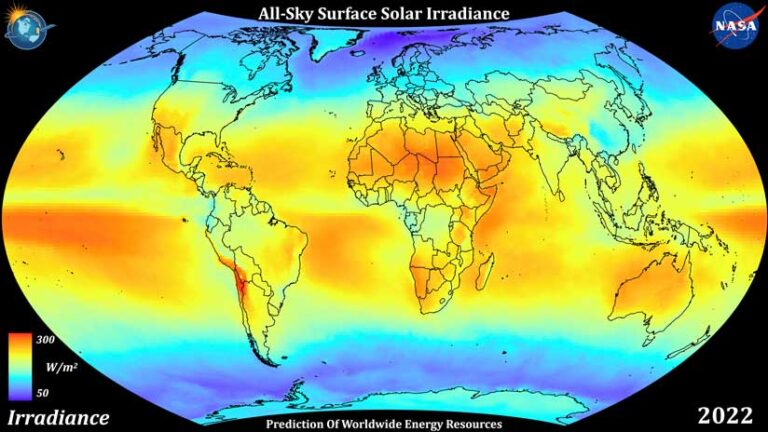
The Prediction Of Worldwide Energy Resources (POWER) Project is one of many NASA Earth science projects hosted within the EGIS. POWER is a cornerstone project for NASA’s Earth Action Program. POWER’s goal is to provide communities tackling energy and infrastructure challenges access to free, geospatially enabled NASA solar and meteorology datasets via ArcGIS image services that are hosted on EGIS.
The GIS community can benefit from POWER’s geospatial services, which offer data in an easily accessible, GIS-friendly format. The POWER Project has worked continuously for 26 years, innovating its GIS-based tools and services and supporting the GIS community.
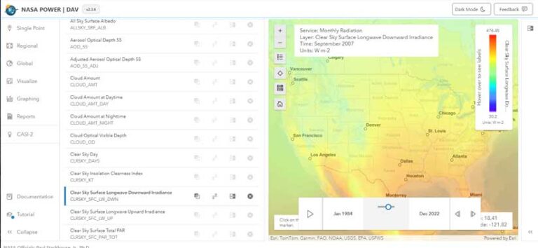
For example, POWER’s Data Access Viewer (DAV) and PaRameter Uncertainty ViEwer (PRUVE) tool directly utilize the project’s image services and serve as an example of how users can use POWER’s services in the backend for developing their own tools. Applications, like the DAV, provide users direct access to POWER’s Application Programming Interfaces (API) while enabling them to create plots. DAV and PRUVE were developed using the Esri Calcite Design System.
Products That Make EO Data Accessible
The POWER Project strives to make EO data easily accessible to users. More than 500 million data requests have been fulfilled since the project’s inception. To attract a diverse usership, POWER offers a suite of tools that provide GIS-friendly, community-specific data that can be easily and efficiently integrated into GIS services and platforms.
DAV, a web application mapping system, provides visualization tools, charting, and data download capabilities. DAV products can be easily downloaded or integrated into custom applications and software. Subset datasets can be obtained by selecting location, time period, file type, and other parameters that enable users to acquire just the data that is relevant to their purposes.
Currently in development, PRUVE is slated for release in late 2024. This tool works as an online, dynamic validation application that utilizes statistical analysis and visualization. It will compare in situ surface site data with POWER data. The comparison data for solar radiation comes from the Global Energy and Water Exchanges (GEWEX) program and the Global Climate Observing System (GCOS) and Baseline Surface Radiation Network (BSRN). Meteorological comparison data is acquired from the National Oceanic and Atmospheric Administration (NOAA). The PRUVE tool will allow users to assess data in a web framework, which improves accessibility and eases the complexity of assessing data uncertainty.
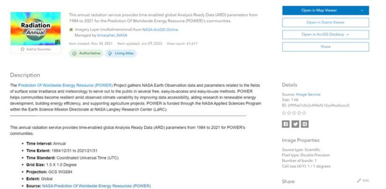
Geospatial services, DAV, and the PRUVE tool are all POWER services that help users address geospatial challenges and create opportunities. This past year, POWER released 16 updated and new multidimensional ArcGIS image services that the GIS community can leverage for its projects and research. POWER’s geospatial services allow users to visualize and explore POWER data as well as enable the data to efficiently interact with GIS applications and tools.
POWER geospatial services include data on:
- Monthly and annual climatology solar and thermal radiation.
- Monthly and annual climatology meteorology.
- Monthly and annual U and V wind components [i.e., geographic wind coordinate system Ugeo, Vgeo] as well as monthly wind speed.
- Tilted surfaces irradiance, horizon (solar geometry), azimuth (solar geometry), and battery sizing for grid independent facilities climatology.
- Thermal climate zones and build thermal moisture climate zones for the period 1981–2021 and difference maps for both types of zones are derived for the most recent 15-year period (2007–2021) minus the earliest 15-year period (1981–1995) to illustrate variability.
- With these geospatial services, which are hosted within the NASA EGIS Enterprise, users can access data via the enterprise’s web browser, NASA ArcGIS homepage, or by searching ArcGIS Living Atlas of the World. POWER’s geospatial services can also be directly accessed using ArcGIS Pro.
A Key Data Provider
The POWER Project is uniquely positioned to support users in three areas: renewable energy, sustainable infrastructure, and agroclimatology. POWER serves as a key data provider to these communities by offering customized NASA EO data products that can be used to meet the demands and needs of these unique markets. POWER addresses market necessities by providing application-ready formats, long time series, globally gridded data, low-latency parameters, and community-specific, value-added data parameters.
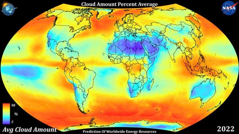
Utilizing information from NASA’s Clouds and the Earth’s Radiant Energy System (CERES) project and Global Modeling and Assimilation Office (GMAO) Modern-Era Retrospective analysis for Research and Applications, Version 2 (MERRA-2) data products, POWER provides more than 400 parameters. Surface solar irradiance data dates back until 1984, with meteorology data since 1981, which enables users to compare how the Earth’s climate functioned, previously and currently. POWER offers data in hourly, daily, monthly, annual, and climatology time periods.
The POWER Project values input from its diverse user community and takes their needs into consideration. The user community ranges from government agencies to nonprofits to industry, both domestic and international. They have found POWER data products and tools to be instrumental in their work due to its near real-time data distribution and global availability for all parameters offered. Many research projects study remote regions of the world where data acquisition is difficult or impossible. The project’s array of tools and services can meet the needs of many groups with various technical, investigative, and developmental backgrounds.
Finding Sustainable Solutions with POWER Data
POWER GIS data has had an impact on a global scale when it comes to finding sustainable energy solutions in areas such as renewable energy, wastewater treatment, agroclimatology, and assessing energy budgets.
At Arunai Engineering College in Tamil Nadu, India, Dr. Saravanan Vasudevan, with the support of his team, installed a 10-kilowatts peak (kWp) solar photovoltaic microgrid system on the college site. The team used DAV to acquire solar and meteorological data, which allowed it to forecast solar power generation. As of June 12, 2024, the system has generated close to 30,000 kWp of electrical energy. The system saves about $100 per month, or 5 percent of the school’s total budget. It is not only used for sustainable energy, but also for education. The system provides an opportunity to educate future scientists and engineers and discuss the importance of solar energy sustainability in accordance with the United Nation’s Sustainable Development Goals.
Produced Water Ecoservices (PWES), a company based out of Colombia, uses a mechanical evaporation process for treating and returning wastewater to its original purity on-site for industrial facilities. Treating water on-site saves transportation costs, shortens the water treatment cycle, and reduces the risk of environmental spillage. PWES has successfully treated and returned more than 2.5 million barrels of water, while assisting the production of 300,000 barrels of oil.
Mechanical water evaporation is a process that is very sensitive to surrounding meteorological conditions, so PWES utilizes DAV for meteorological data. PWES vice president Hubert Borja Quintero said, “POWER’s data access platform has been a very valuable resource of meteorological data, especially in an area where the weather station network is poor or absent.”
The Future of POWER
NASA’s POWER Project aims to introduce projected climate risk information and continue serving the missions of its unique user communities. The project plans to expand spatial coverage of its climate data products regionally and globally, enhance spatial resolution of datasets regionally across the United States, and develop data products that include new satellite datasets.
POWER is always looking for partnerships that will strengthen its impact across the world. One partner, RETScreen International of Natural Resources Canada, uses NASA POWER data to support analyses from its RETScreen Expert Clean Energy Management Software. Using POWER data with this software, the RETScreen team plans on expanding climate prediction calculations to NASA buildings and more locations across the United States and the world.
The NASA POWER Project will continue to serve its communities and make improvements based on their needs. Earth science is vital to understanding a dynamic and ever-changing Earth. POWER provides insights that can improve renewable and sustainable practices that support a flourishing world for years to come.
