A city cemetery was established in Oxford, Ohio, in 1817, but burials didn’t begin in Oxford Cemetery until 1855. In 2023, the city took over management of this cemetery, and quickly realized that the cemetery records were incomplete. The Oxford Cemetery Association, which ceased operations in 2022, had left only partial records of who was buried there and where their graves could be found.
“The records that the city got from the cemetery association were stacks of interment cards,” said Robbyn Abbitt, GIS coordinator for Miami University of Ohio and associate director of the school’s Geospatial Analysis Center. “[The city] also had big paper maps with a grid system that showed ownership. But there were no maps or comprehensive lists showing where people were actually buried. This was a problem, because sometimes the lot owner is not the person interred. There was no way to look up and find who was there and how to find them.”
In addition, the paper maps were not drawn to scale, and they showed roads and pathways that have since changed.
To help preserve this site’s historical relevance, city staff turned to Abbitt, who guided 54 GIS students—using tools such as ArcGIS Pro, ArcGIS Online, ArcGIS Field Maps, and ArcGIS Hub—to gather cemetery data and then map and share the results.
Putting the Pieces Together with GIS Technology
“The city now has to manage this property,” Abbitt said, “and managing something is hard without knowing what’s there. You had to wander around and hope that the lot owner is the same person or [has the same last] name as the person who is interred.”
On the other hand, the students had a useful resource: notes taken in the 1960s by a local historian named Hazel.
“Hazel had cataloged everyone’s name up to the mid-sixties,” Abbitt said. “That was helpful for headstones that we can no longer read.”
Abbitt listed several desired data categories: veteran plaque placements, empty lot locations, and places where only one partner is buried but both are named on the headstone.
Working for more than 500 hours combined during the university’s fall 2023 and spring 2024 semesters, the students defined locations for more than 6,300 headstones and processed more than 4,300 interment cards.

The project began with data collection. Students used ArcGIS Field Maps, drone imagery shared by the city, and digitized historical maps to collect features throughout the 31.4-acre property. Using the Create Fishnet geoprocessing tool in ArcGIS Pro to designate sections and individual grave sites, each student could conduct individualized research and build a web map with their own data layer—all while sharing results as they were entered. For their final projects, students were put into teams to create web maps, web apps, and dashboards using this data.
“From a teaching perspective, the ability of multiple people to edit in a single feature class was amazing because it was like an enterprise system. The ability to group edit was a game changer,” Abbitt said.
Using ArcGIS Pro, students could combine their results in a database that included headstone attributes linked with information from hard-copy interment cards from the cemetery files. Data was then stored as feature classes in ArcGIS Online, so the students could easily continue working on and access the data for future visualization needs.
Newly available drone imagery provided a level of detail that Abbitt said was unavailable for her previous GIS classes’ projects.
“With drone imagery, we only missed maybe 10 headstones out of more than 6,000,” she said. “We loaded the drone imagery into ArcGIS Online and created a feature service that anyone in the group could edit, and it was built to go into Field Maps when needed. The drone imagery was so good that we could lay down points for everything that looked like a headstone, with no GPS adjusting needed.”

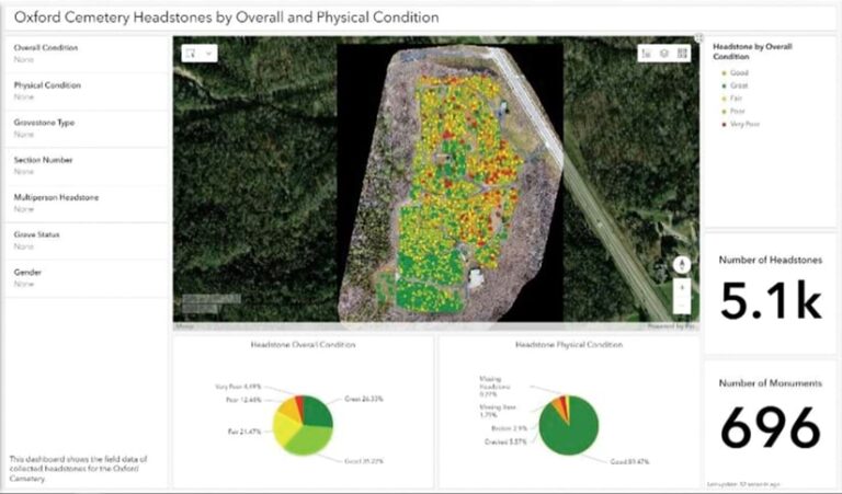
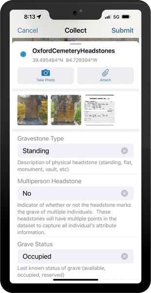
After gathering and integrating this data, the students used various methods to visualize and present information about the cemetery. Tools such as ArcGIS Pro and ArcGIS Online enabled data creation and integration. ArcGIS Field Maps facilitated adding photo attachments and updating data the students collected in the cemetery. ArcGIS Dashboards and ArcGIS StoryMaps helped students tell stories and provide context beyond what was found on the headstones.
Linking Lives and Locations
The results—collected on a website created with ArcGIS Hub—include the students’ maps, apps, and stories created with ArcGIS StoryMaps, providing details such as headstone conditions, notable gravesites, and stories of former town residents interred in the cemetery.
One such story, titled “The Unsung Heroes of Oxford Cemetery,” describes the childhood friendship and 52-year marriage of Shirley and Robert Younts—including their daily crossword puzzle competition; Shirley’s work at the university’s zoology department; and Robert’s experiences as a university flight instructor, including piloting flights for Martin Luther King Jr. and astronauts Alan Shepard and Neil Armstrong.
After the students completed the project, city staff spent some time determining what to do next with the data for long-term management of the cemetery. Now, the City of Oxford and Miami University have collaborated using ArcGIS Online so that the city can use the data collected by Abbitt and her students to actively manage and update records.
With all this information plus online access to student-made digital maps, associated details, and personal stories related to Oxford Cemetery grave sites, visitors can better understand the cemetery and how it provides connections with the past.


