2020 Census Demographics and Housing Characteristics Available in ArcGIS Living Atlas of the World
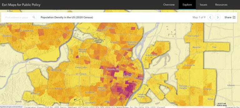
In the second quarter of 2023, the US Census Bureau released the 2020 Demographic and Housing Characteristics File (DHC), which contains 249 tables with nearly 10,000 attributes on topics such as population, age, sex, race and ethnicity, household type, occupancy, family type and more. The ArcGIS Living Atlas of the World policy maps team compiled the most popular tables into hosted feature layers in ArcGIS Online, organized by topic and geography.
The hosted feature layer provides total population counts as a nested layer containing nation, state, county, tract, and block group geographies. Five additional layers for total population provide legislative, place, metro, school, and tribal geographies. The total population is broken down by single race/ethnicity, male or female by age, urban and rural populations, dependent age groups, and relationship to householder. Tables have been joined to 2020 Census TIGER boundaries trimmed along coastlines, lakes, and major rivers to create cartographically pleasing maps of census data.
Essential metadata is built into the layers and can be accessed from within ArcGIS products. Since a differential privacy algorithm has been applied to this data to protect the privacy of respondents, the census bureau encourages data users to aggregate small populations and geographies to improve accuracy.
Collaboration Makes Advanced Spatial Analytics Available to Data Scientists
Analyzing data in a geographic context can uncover patterns, make predictions, and optimize workflows to create operational efficiencies. Esri has partnered with Databricks, the data and AI company, to provide users with advanced spatial analytics capabilities of ArcGIS software, made easily accessible in Databricks’ big data platform, the Databricks Lakehouse Platform. This integration will allow data scientists to access the most comprehensive set of spatial analytics tools available natively within the Databricks environment.
Esri Founders Receive Conservation Visionary Award
The International Land Conservation Network (ILCN) honored Esri founders Jack and Laura Dangermond with the Conservation Visionary Award at the 2023 Geodesign Summit. The award recognizes the Dangermonds’ ongoing work toward understanding the connection between humans and the planet to help build a more sustainable world.

ArcGIS Pro Add-On Provides Access to EarthCache Data
An ArcGIS Pro add-on enables ArcGIS users to access, manage, and distribute high-quality satellite imagery from SkyWatch’s Earth observation platform, EarthCache. ArcGIS Pro users can publish to ArcGIS Online; create tiled basemaps from disparate georeferenced images; and customize how acquired data is saved, shared, and managed without maintaining commercial relationships with each data provider. Download this add-on.
Boosting Geospatial Services for Rwanda’s Social and Economic Development
In July 2023, the Rwanda Space Agency (RSA) and Esri signed a memorandum of understanding (MOU) to establish a collaborative partnership that will provide the foundation for promoting geospatial services to drive socioeconomic development in Rwanda. This agreement aligns with RSA’s mission to harness space and GIS to foster sustainable and cross-sectoral development in Rwanda. In joining with Esri, RSA plans to leverage advanced geospatial technologies to address various developmental challenges and support a more prosperous future for Rwanda.


opens in new window
