In El Paso County, Texas, the Lower Valley Water District (LVWD) investigates unusual spikes in water use and monitors water rights, often in partnership with other water districts, such as El Paso Water. For years, those investigations involved dusting off paper maps and manually keeping track of customers and violations. If it turned out that there was a violation and a water user pushed back, there was little physical evidence to prove otherwise.

That changed when LVWD adopted a GIS-centric approach to its investigations, shifting information collection online and including photos of violations. Now the utility can clearly identify issues, such as when residents illegally dig canals, install pumps, or flood their properties to access water that isn’t theirs.
“We’re able to prove that residents are stealing water,” said LVWD’s IT director Ryan Rodriguez, who explained that mobile crews can now show residents maps and photographs of violations or disputed water rights claims on an iPad. “There is proof in the picture. A picture says a thousand words.”
When Rodriguez joined LVWD in 2018 as the IT director, he noticed that the utility hadn’t taken advantage of its existing location intelligence tools. Rodriguez advised LVWD to modernize its operations by fully embracing GIS technology. He saw GIS as a go-to solution and felt that the rest of the organization would come around to that thinking, too.
Becoming a geospatially driven organization would not be easy. But putting in the work would address challenges across multiple facets of the business, ultimately improving workflows and providing better service to residents. First, however, staff members would have to undergo GIS training—an essential step to agencywide GIS adoption.
GIS Training Across the Utility
To help key LVWD staff members learn the technology, Rodriguez and his team created a plan for them that leveraged support and educational resources available through the Esri Advantage Program. The team started by assessing where GIS tools could solve critical business problems in various departments.
Rodriguez met with stakeholders, mobile workforce staff members, team leaders, and other potential users to identify challenges and brainstorm GIS-based solutions. Takeaways from these conversations included the need to create apps, visualize data with dashboards, migrate data, upgrade databases, and update workflows to improve data quality.

Building from those business goals, Rodriguez worked with a team from Esri Services to develop a training program for LVWD GIS users that ranged from beginner to advanced. Rodriguez himself completed six training courses, including Using ArcGIS for Water Utility Workflows and ArcGIS for Server: Site Configuration and Administration. He and other employees also took courses related to key GIS workflows such as data management, mobile GIS, map design and visualization, spatial analytics, and enterprise administration.
Finding Ways to Better Serve Residents
In addition to working on a new workflow for water rights investigations, Rodriguez and his team focused on developing solutions for water management and waste modernization.
Rodriguez used ArcGIS Pro to create a map that tracks and highlights water meters around the county, helping operations managers determine which water meters—out of 12,000—need to be replaced. He also worked with the solid waste department, using ArcGIS QuickCapture to plot current trash pickup routes and create optimized itineraries for future operations. GIS even proved helpful to human resources when, in the early months of the COVID-19 pandemic, Rodriguez assisted the department in developing a questionnaire with ArcGIS Survey123 to track employee exposure to COVID-19 with the aim of reducing risk.
“While it has been a challenge to get everyone to adopt using this technology daily, I would say every department in some way has benefited from using GIS,” Rodriguez said.
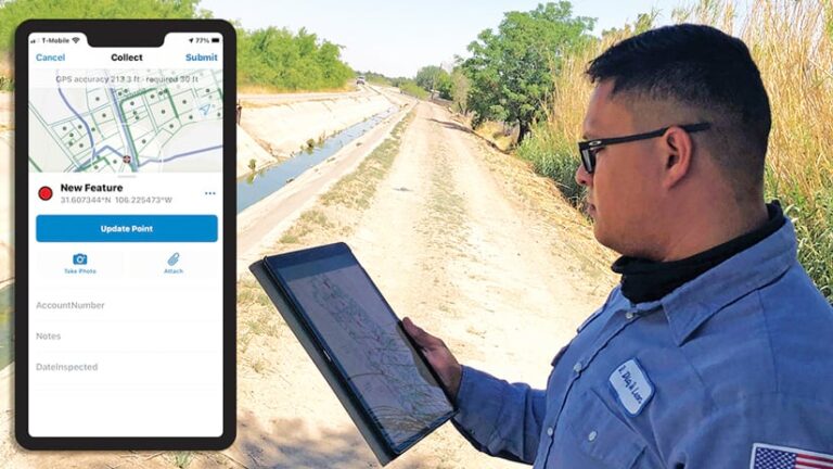
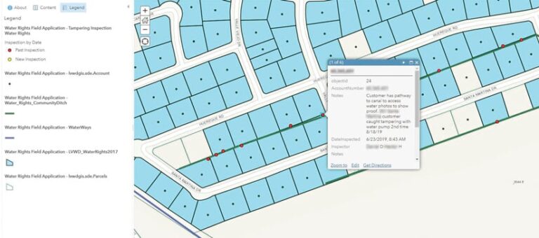
That is what happened with the water rights department. After seeing the benefits GIS brought to other divisions, officials came to Rodriguez and his IT team to get help with tracking violations. Rodriguez built a mobile data collection app using ArcGIS Collector that stores customer account information along with details on ditches and canals throughout El Paso County. This information integrates with ArcGIS Pro to create a data-layered map.
The app allows utility staff members to edit canals and submit photos and videos, enabling field personnel to take pictures of violations and attach them to their reports. The reports supply water rights management with vital real-time data. Additionally, the app has fillable fields so users can enter notes, account numbers, inspection dates and times, and the inspector’s name.
“It Made Their Job So Much Easier”
Collaboration among the water rights staff, Rodriguez, and Esri Services yielded positive results. The app provides mobile workers with easy access to customer information, allows them to capture proof of stolen water and issue citations, and enables increased cooperation between mobile and office staff. So far, the app has helped the team prove 92 violations and issue appropriate penalty fees.

Rodriguez and his team received positive feedback for their work on the app, which has encouraged more departments to reach out with requests for similar solutions.
“[Water rights staff members] are just loving the application because it made their job so much easier, and I know they’re going to be using it more,” said Rodriguez. “If anything, it probably created a little bit more work for us because they realized how quickly we can make applications.”
After successfully implementing training, adopting more ArcGIS technology, and building unique apps like the one used to determine water rights violations, LVWD has a bright future with GIS. Rodriguez and his team envision more uses for the technology—for billing, tracking unreported hydrant use, maintaining meters across the district, and even expanding into solid waste management.
“I think [GIS] has made everyone more efficient,” said Rodriguez. “Everyone is using it now. I feel that whenever a problem arises, people come to me to see if I can figure out a solution.”
With a growing list of projects, Rodriguez hopes to continue collaborating with Esri Services as his organization works toward becoming even more geospatially driven.

