the farmer pushed the slow earth into teats • primed
with water • worried with seed. still the rice
wandered into shrapnel • stalks ripen into flame.Dennis Schmitz, “Vietnamese”
By the time the Vietnam War ended in 1975, 7.5 million tons of ordnance—including cluster bombs, grenades, and land mines—had been dropped on Vietnam, Laos, and Cambodia. The Vietnamese government has estimated that 10–30 percent of it failed to detonate. Over the last 40-plus years, about 105,000 Vietnamese have died from or been injured by these explosive remnants of war (ERW).
Throughout the world, there are more than 60 countries contaminated with ERW. According to some estimates, more than two billion square meters of land are currently lost to the threat of ERW. These munitions can sit for decades underground, primed and ready to explode when disturbed by agriculture, construction, or curiosity.
To help curb the widespread incidence and broad impact of ERW, the nonprofit Geneva International Centre for Humanitarian Demining (GICHD) was established in Switzerland in 1998. The organization works in close partnership with national authorities and international and regional organizations all over the world to reduce the magnitude of ERW and their effects.
“Our ultimate goal is to save lives, return decontaminated land to productive use, and promote development,” said Olivier Cottray, head of information management at the GICHD. “We do this through various initiatives that focus on mine removal, strategic planning, and information management.”
As part of its efforts, the GICHD provides the Information Management System for Mine Action (IMSMA), an information management tool that gives the mine action community enhanced decision support, spatial analysis, coordination, and reporting capabilities to increase the efficiency of demining activities. Recently, the GICHD developed the newest iteration of the system as a web-based GIS environment. Called IMSMA Core, this system is rooted in ArcGIS Pro and ArcGIS Enterprise.
While getting the web-based functionality was important, it was going to be difficult for the GICHD to keep IMSMA operating smoothly during the transition. So the organization contracted Esri’s Professional Services to help develop the newest generation of its system.

Managing Mine Action with GIS
IMSMA is key to much of the GICHD’s work and has become the de facto standard for information management systems in the mine action sector, according to Cottray. The GICHD provides the system to governments and nonprofit organizations all over the world that are involved with the removal of ERW.
“We do not maintain the data for the various national entities and other agencies that use the system, as often that is a matter of national security for them,” said Cottray. “But we do provide training and support for their use of the system.”
The GICHD has used Esri technology for all the system’s iterations from the very beginning.
“The first generation of IMSMA was implemented using ArcView with a MySQL database,” recalled Cottray. “The next generation, IMSMA NG—which is still in use in over 40 countries today—uses a Java-customized client/server app on top of PostgreSQL, and runs ArcGIS Engine.”
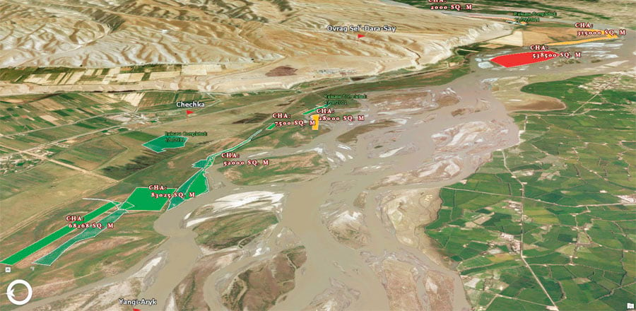
Now, for this latest iteration, IMSMA Core can put all the ArcGIS capabilities to the service of mine action, including route analysis, terrain modeling, predictive modeling, buffer zones for suspected ERW, automated reporting, and drones for imagery collection.
“We are also creating a complement of web apps that allow various users easy access to the specific information they need for their work,” said Cottray. “The updated system will open up all sorts of new possibilities in terms of what we can do with mine action data.”
A New Modular System to Meet Changing Needs
The GICHD contracted Esri’s Professional Services team in 2016 to implement IMSMA Core.
“It has been a complex task to support existing IMSMA workflows while bringing in the new functionality offered by a web-based GIS environment, made easier by providing access for pilot programs and testing using cloud-based hosting during the development process,” said Sam Libby, the technical lead from Esri on the project. “We developed the system architecture through close collaboration with the GICHD and have built IMSMA Core based on ArcGIS Enterprise and ArcGIS Pro, with heavy usage of Survey123 for ArcGIS for structured data collection. We also helped convert existing information management workflows for use with ArcGIS Pro and provided web-based applications for data review, editing, and approval.”
Professional Services collaborated with Esri Switzerland for local support. And in 2017, the team successfully piloted the system with several partners in different countries.
IMSMA Core is modular and allows the GICHD’s partners to easily access those components specifically related to their work. What’s more, many United Nations (UN) agencies and departments, as well as nongovernmental organizations (NGOs), use the ArcGIS platform for different aspects of humanitarian work, including human rights monitoring, refugee support, food distribution, education, finance, agriculture, peacekeeping, and disarmament. IMSMA Core is therefore completely compatible with these systems and allows those in the mine action community, as well as in the wider human security realm, to more easily share vital operational information with one another.
Our ultimate goal is to save lives, return decontaminated land to productive use, and promote development.
Simplifying the Training Process
Because the GICHD works with so many countries at varied stages of ERW removal, it was important to have a simple training process. Thus, the GICHD standardized the roles required to manage the information associated with mine action and specified the levels of IMSMA expertise needed to perform those roles. It then created the Mine Action Information Management Qualification Scheme.
With that, “we can now keep track of who is qualified and at what level, whether they are administrators, specialists, developers, or end users,” said Cottray. “It helps us determine, country by country, what the level of skill is and helps us target those countries that require further capacity development.”
From there, the GICHD relies heavily on ArcGIS training materials to build people’s skills and keep them up to speed.
“With IMSMA Core and because of the many training modules that Esri has developed for ArcGIS, we can now spend less time and energy on creating material,” said Cottray. “We can simply tailor training tracks using existing Esri materials to meet the needs of particular user groups in their local language. This [allows] us to focus more on understanding their information requirements and on translating those requirements into processes and tools for implementation in their IMSMA.”
The Workflow’s Digital Transformation
National governments are responsible for mine action, but it is implemented by a variety of agencies, including commercial companies, NGOs, the military, UN agencies, and community-based organizations. It is generally a combination of these entities that works to eradicate ERW.
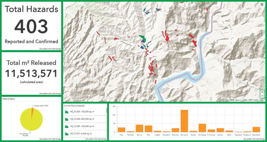
“The standard workflow starts with a nontechnical survey with local populations to understand from their witness accounts what the extent of the ERW hazard might be in that area,” explained Cottray. “This is followed by technical surveys to identify more precisely the areas actually contaminated. These surveys generate an enormous amount of field data. Currently, these are captured through paper-based forms, but with the implementation of IMSMA Core, the field surveyors are now able to make use of Survey123 and Collector for ArcGIS. The submitted data goes through a number of validation processes to ensure the best possible quality before it is committed to the national database. It can then be used to provide the overall picture of the contamination problem in that country and analyzed to determine land clearance priorities. Clearance tasks are then assigned to operators who go out and perform the actual demining. As they start clearing an area, the revised contamination status of the land flows back up to the national database so that decision-makers can keep track of the progress being made. This entire process is supported in IMSMA Core by the use of mobile and web applications that each performs specific tasks along the way.”

To facilitate the process, the GICHD has also developed a multicriteria prioritization tool called PriSMA that allows mine action stakeholders in any community to express their priorities. Minefields can be fast-tracked for demining if they are located near areas and facilities that local residents are required to visit, such as hospitals, schools, and agricultural land.
“The impact of clearing each of these hazardous areas will vary according to the overall needs of the community,” said Cottray. “PriSMA provides a very interactive way for stakeholders to set their criteria for demining priorities, and then it determines an impact score for clearing each specified area.”
The Next Technological Steps
Employing remote sensing to a greater extent is the next big technological step in mine action, according to Cottray.
“We are carefully watching the research being done with multispectral analysis to see whether or not we can find spectral signatures that are characteristic of contaminated areas,” said Cottray. “A few studies, for example, use the Normalized Difference Vegetation Index, which looks at the health of vegetation. The theory is that when the nitrates in explosives leak out, it can actually boost vegetation growth. So these sorts of anomalies in vegetation in postconflict areas might provide clues to the presence of unexploded ordnance there. The problem is that there’s too much noise and ambiguity in the spectral analysis at the moment, which produces false positive readings.”
Mounting ground-penetrating radar on vehicles to detect the location of hard objects underground may have some potential as well.
“This is also promising, but we are again seeing too many false positives at the moment,” explained Cottray. “The mine action sector is fairly conservative in adopting new tools because of the risks involved in getting it wrong.”

