City of Surrey Fire Service Focuses on Fire Reduction Education Programs
In fire and rescue, prevention is the primary phase for creating safer communities. While focus is always on getting to the emergency faster and being better equipped, the new frontier is information sharing—and teaching people, businesses, nonprofits, and communities to understand how they can make their homes and offices safer. One agency in Canada—the Surrey Fire Service—is putting geoanalytics into this formula. The agency created a focused home inspection that resulted in fewer residential fires/emergencies.

Surrey Fire Service and the Surrey Fire Prevention Branch provide emergency response for fire and medical emergencies to the citizens of Surrey, British Columbia (BC), Canada. The agency has 17 stations covering 123 square miles with a population exceeding 450,000 people and worked more than 27,000 emergency and nonemergency incidents in 2011.
Deputy fire chief Larry Thomas has been with the service for 23 years, starting as fire fighter. While working with fire chief Len Garis on restructuring the Prevention Branch, the two discussed the need to find a more effective method for public fire prevention education. Like many fire departments, the approach of the day was very broad brush, primarily directed at educating children in school. Resources were dedicated to general fire prevention education with no real ability to measure if the education was effective or not.
Evolution
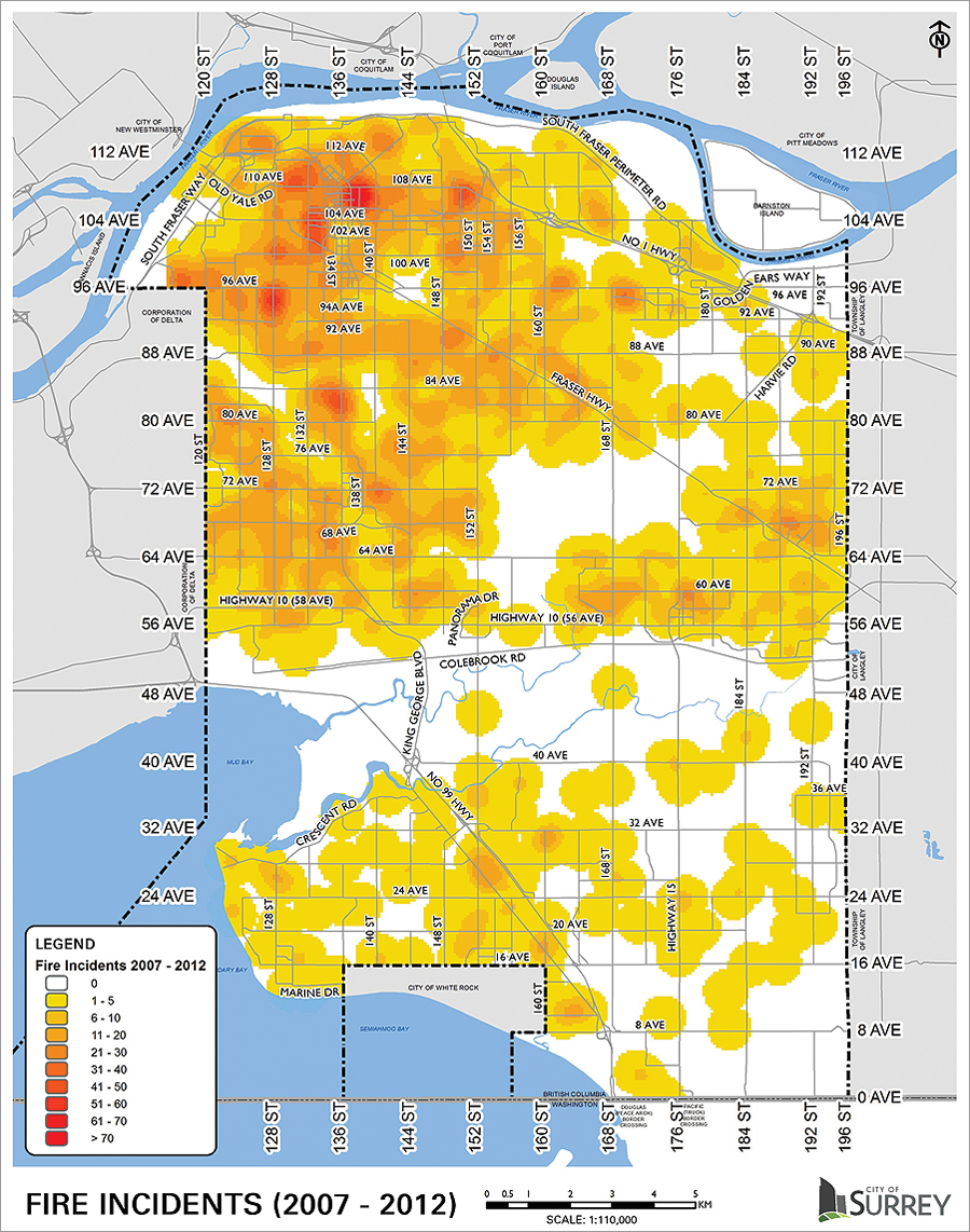
In 2007, the University of the Fraser Valley conducted research using the Surrey fire incident database covering a 20-year period. The research identified the most common types of fires and the demographics associated with the most common fires. The results painted a focused picture:
Young, elderly, and economically challenged residents were more likely to experience a fire than other citizens.
This problem statement led Thomas and Garis to devise a process for fire prevention education that could be measured. With the assistance of City of Surrey strategic analyst Dr. Joe Clare, they planned a study that directed fire prevention education to targeted homes and developed a means of measuring its effectiveness. They would measure over time if a reduction in home fires occurred in the targeted areas compared to similar demographic areas that didn’t receive the education. To facilitate the study, fire education packages were developed to address the communities’ most common fire causes to raise awareness among the most vulnerable.
By this time, the team realized that an important tool in the research would be GIS, and it so happened that the City of Surrey GIS department had been using ArcGIS for many years and had won several Esri awards for excellence.
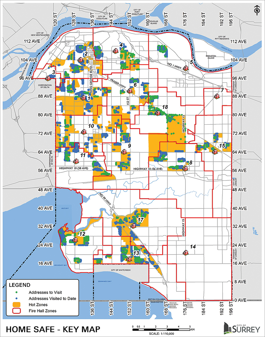
“So contacting our GIS department for support was essential for the success of our program,” says Thomas. Staff needed to identify targeted and nontargeted areas of similar high fire risk. They used ArcGIS to plot residential fire locations with data from the department’s computer-aided dispatch system. Then census information was used to locate children under 6 years old, adults over 64, single-parent families, and unemployed residents. Census data about dwellings was also used to capture the risk posed for residential structures, such as building age. City zoning data was used as a layer to ensure single-family residences were targeted.

This was achieved by identifying areas of the city with a large proportion of dwellings constructed prior to 1991. The distributions of risk were blended within ArcGIS, and a set of high-risk zones was identified across the city. Location analytics helped target addresses used by fire crews to deliver fire prevention education packages in person, door to door.
“GIS played an extremely important role in identifying the specific high-risk locations so a targeted study could be measured,” says Thomas. “GIS allowed us to use demographic data to identify locations that met the study parameters for risk. It has provided us with the ability to test our theories, measure them, and reduce home fires by using targeted education at high-risk locations. It has given us another tool to help apply a cost-benefit analysis to education initiatives.” The study lasted 25 months, and more than 18,000 homes received the education packages. The results were amazing. Areas that received educational packets delivered door to door experienced a 63.9 percent reduction in home fires compared to preintervention rates of fire per 1,000 homes.
“Prior to using GIS data, we would rely on anecdotal experience by administrators to target at-risk neighborhoods utilizing a shotgun approach,” says Thomas. “The ability to measure change was not practical.”
Reporting the Results
The results of the GIS work were cataloged, quantified, and distilled into a detailed report written by Clare. “It documents measurable results that clearly communicate the process so it can be implemented virtually anywhere,” says Thomas. After peer review, the Journal of Safety Research published the report. “The mechanism for delivering preventive interventions in the home and the approach with GIS,” continues Thomas, “will drive target selection for future iterations of this home education campaign.”
According to Surrey Fire, the mapping process used to identify where to target prevention efforts could also be enhanced by building on the hot spot identification and demographic locations of high-risk citizens. Such a strategy would ensure that prevention efforts are continually focused on the areas of the community with the greatest need. Indeed, there are benefits from sharing information among service providers who work with high-risk members of the community and the fire service. The range of social service infrastructure could include police, health bodies, voluntary organizations, community outreach teams, and local advocates, all working in partnership with the fire service.
“Our next application will be to refer those at greatest risk of residential fire to have smoke alarms installed free of charge,” explains Thomas. “Canadian estimates suggested present and functioning smoke alarms can reduce occupant death by up to 42 percent, while the US Fire Administration suggests this reduction can be as large as 63 percent. As we further develop our program, we are planning to look at fall prevention and other education awareness initiatives for seniors.”
For more information, contact Larry Thomas, deputy fire chief, City of Surrey.

