Sophisticated Cell Tower Analysis Helps Los Angeles Law Enforcement Pinpoint Criminals
Catching criminals and enforcing the law can be arduous and time-consuming. It’s a piece-by-piece, evidence-based process. And it doesn’t stop at apprehension. Arming prosecutors with the evidence they need to get a conviction is just as vital.
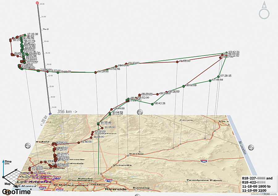
For years, tracking cell phone usage and location information has helped law enforcement put offenders behind bars by establishing motive, placing suspects at the scene of a crime, reconstructing timelines, and connecting suspects to victims and each other. Unfortunately, the technology used in these types of investigations has been limited. Reconstructing timelines can take investigators many hours. And while hand-drawn link charts and paper maps have helped, they’ve lacked intuitiveness, and connections may be missed. Two-dimensional maps don’t clearly show the necessary relationship between cell towers, call locations, cell phone movement, and criminal activity. Moreover, the lack of a temporal dimension—which tracks movement through time as well as space—limits the effectiveness of the map.
The Los Angeles Regional Criminal Information Clearinghouse (LA CLEAR) has implemented an innovative approach to addressing these challenges. Using a solution based on ArcGIS from Esri Partner Oculus Info Inc. (Toronto, Canada), the agency has rapidly streamlined the mapmaking process for tracking cell activity. It has overcome the time and dimension problem as well—sophisticated 3D maps can show movement and activity over time, whether it’s throughout the course of a day, a week, or an entire month.
LA CLEAR and the Need to Track in Both Time and Space
Based in Los Angeles, LA CLEAR is nationally recognized and modeled after the US government executive branch’s Office of National Drug Control Policy’s High Intensity Drug Trafficking Area (HIDTA) Intelligence Support Center. LA CLEAR provides strategic investigative research and postseizure analysis, tactical case support analysis, electronic surveillance capabilities with accompanying operational intelligence support, and training and conference opportunities to the more than 184 LA HIDTA-specific agencies and task forces within the four counties of the LA HIDTA.
LA CLEAR is managed by sworn law enforcement executives and staffed by a fully integrated team of nonsworn law enforcement, military, and contract specialists organized into the following component units:
- The Intelligence & Deconfliction Watch Center (“war room”)
- The Analytical Unit
- The Special Operations Support Unit
- The Los Angeles HIDTA Training Initiative (hosted by LA CLEAR)
- The Information Systems Support Unit
- The Administrative Support Services Unit
For years, LA CLEAR analysts have mapped individual crimes, the locations of known criminals and suspects, and related crime activity. This has proved invaluable in assisting law enforcement.

In particular, mapping the use of cell phones by criminal suspects assists in making arrests and securing convictions. Yet it hasn’t always been easy.
“We were limited to two-dimensional views of cell tower hits,” says Toni Nunez, senior lead analyst, LA CLEAR. “Deputy district attorneys were asking us for something that could express both time and space for their court presentations.”
For example, these first digital maps did not clearly display multiple hits in the same location over a period of time. On a two-dimensional map, one dot appears where, in fact, there are multiple calls. A three-dimensional map extrapolates this information in time to allow anyone using the map to easily visualize and understand where multiple calls and violations have occurred over time. Staff needed to find a way to include time variables within its maps to be able to see if two suspects were not only at the same place but at the same place at the same time.
After looking at different technologies, LA CLEAR staff contacted Oculus to view demonstrations of its GeoTime solution, which provides data visualization and analysis, specializing in the display of movements and events over time. It provided LA CLEAR with a unique 3D time viewer to simultaneously visualize geospatial, temporal, and link data. It was exactly what LA CLEAR needed to support its mission.
With its new capabilities, LA CLEAR was able to map cell towers, which in turn allowed it to assimilate and comprehend complex cell datasets. Officials could make faster, more accurate decisions by identifying where suspects had been and where they were headed.
After a successful evaluation and trial period, the agency implemented the solution in 2010. LA CLEAR then expanded its Esri ArcGIS license for all analysts who would be mapping cell sites, and analysts are trained in both ArcGIS and GeoTime.
Expanding the Map
Eighteen analysts use ArcGIS in the agency’s war room to plot critical events, such as search warrants, surveillances, and active cases involving other agencies, onto situational maps. They also enable detectives to deconflict cases—or connect agencies that may be working the same address/location so that they are aware of each other’s presence. Prosecutors can use the mapped information to help win cases.
Another nine analysts use ArcGIS and GeoTime to analyze call detail records, gang activity, or illegal drug transportation.
For analyzing call detail records, the analyst can easily map and research call patterns from all major cell phone carriers. This allows investigators to trace movement, reconstruct travel patterns, and confirm meetings and communications between suspects.
Gang member interactions and social networks can be analyzed to place gang members together and in the vicinity of crime locations.
For illegal drug transportation, data is recorded that details meeting locations between dealers and buyers. These locations can then be mapped so that drug houses can be identified and interdictions planned. Vehicles of suspects are also mapped along Los Angeles County highways and streets. This helps law enforcement officials from the 214 agencies and task forces within the six counties that make up LA CLEAR set up future traffic monitoring in high-risk areas. The GeoTime tool is also used for GPS tracking of offenders and suspect vehicles, as well as in courtroom presentations.
Prior to the use of GIS and temporal tracking software, analysts received call detail records provided by the phone company, determined the latitude and longitude of each cell tower during a specific time range of interest, and individually plotted towers into MapPoint. This was a time-intensive manual process, and it was difficult to make changes to produced maps. Analysts can now process in seconds what used to take hours or days.
The process of cell site analysis is an emerging skill and is being used more and more in support of investigations. Datasets containing phone records are subpoenaed from the cell phone companies for investigative purposes. LA CLEAR staff members easily import all subpoenaed cell site keys, which gives GeoTime unique identifiers on which to map locations, allowing analysts to batch import call records for the handsets they requested. The cell tower ID is the unique tower that is identified from the site key. The analyst can map locations by triangulating the points between cell towers. As a cell phone is “pinging” various cell towers used by a person traveling or changing locations, the analyst is able to pinpoint that phone’s location by the towers it is hitting.
At different times, these various views are each invaluable at corroborating or disproving suspect statements about their locations or visualizing different theories of the progression of a crime.
Now a case involving four cell phones will typically take only 4 to 12 hours to develop a presentation that displays slides in three different views. Previously, it would have taken 20 to 30 hours to complete one to four charts for the investigators or court prosecutors.
The maps not only depict cell phone use for the hours surrounding a crime but also depict the entire date range of the cell phone records. An investigator can see if the suspect has typically been in the crime area, cased the location prior to the crime, or left the area after the crime, etc.
“We can see if multiple cell phones meet before or after a crime to, say, deliver or hand off a weapon,” says Nunez. “We can also display all this movement in a video that dramatically increases viewers’ understanding of what they are looking at.”
For more information, contact Toni Nunez, senior lead analyst, Los Angeles Regional Criminal Information Clearinghouse (tel.: 323-869-2576).

