GIS and geographic information science (GIScience), the science that underpins GIS technology, are fundamental to how practitioners and researchers work to advance collective knowledge and solve pressing, real-world problems.
Spatial data and the technologies that support its collection, management, analysis, and visualization have become integrated into daily life, with billions of people using interactive digital maps every day. Smartphones have become modern geographic data loggers, and now anyone with access to the internet can use AI.

These technological advances have had innumerable benefits for humans, but they are also driving major disruptions. Given how crucial spatial data is to modern technology and scientific research, spatial data scientists and GIS practitioners need to be at the forefront of developing solutions to ensure that this field is open, collaborative, and inclusive and keeps up with the latest breakthroughs in technology.
Technological Advances Present Opportunities and Challenges
New technologies are changing how scientists approach problems. Data-intensive scientific discovery has shifted not only the practice of science but also the set of scientific products that researchers prioritize and pursue.
For example, the expanding cyberinfrastructure ecosystem and algorithmic advances in AI have created new modes of discovery that challenge long-standing practices and open the possibility of widespread social reorganization. At the same time, climate change and other societal disruptions continue to alter physical and human geography, shifting the theoretical and empirical rocks on which many scientific disciplines stand.
These disruptions show no signs of slowing anytime soon. Predictive AI, generative AI, and causal AI have reached different levels of maturity, but each needs further development, particularly with respect to spatial data. New forms of spatial data continue to become available in a variety of contexts, resolutions, and veracity, while private industry remains the leading authority to control access. The effects of climate change and communication platforms are apparent, but attribution science and social media research continue to change as the impacts of both phenomena evolve. While these disruptions may serve as a catalyst for innovation and make it possible for humans to tackle the tremendous global challenges at hand, they simultaneously raise ethical questions about science and practice and bring into focus structural barriers to equity and participation in research and education.
How GIScience Can Help Overcome Grand Challenges
It was under this framing that the Center for Spatial Studies at the University of California, Santa Barbara (UCSB), held a specialist meeting in December 2023 on spatial data science in an age of scientific disruptions.
Twenty-five GIScientists from around the world came together to discuss priorities for teaching and research in a time of disruption. Over the next year, papers and conference sessions will broaden participation in the conversation that started at the specialist meeting.
Themes emerged around the need for spatial data scientists to lead open, collaborative, and convergent science; foster inclusion and diverse partnerships; engage more directly in data creation processes; and develop safe and secure infrastructure for accessing private or sensitive data. Participants also noted a resounding need to integrate generative AI and large language models such as ChatGPT into GIS technology and GIScience research and training.
A particularly exciting theme that emerged from the workshop was the idea that GIScience and the geographic approach need to be amplified to overcome these grand challenges. This can be done via collaborative science and community-embedded work.
Working Together to Expand Knowledge
The goal of collaborative science is to cocreate or codesign knowledge in a manner that informs management and decision-makers by involving scientists, practitioners, policymakers, communities, and others to advance understanding in a way that each group could not achieve by working alone.
Codesigning project aims, methods, products, and outcomes first requires a link where participants from varied backgrounds, industries, disciplines, or training can find common ground. Maps often serve as the link that can draw many voices to the table.
Participatory GIS—which brings the practices of GIS and mapping to the local level to promote knowledge production by local and nongovernmental groups—is naturally inclusive and well-suited for codesign. It can, therefore, play a fundamental role in collaborative science that addresses key challenges such as housing, conservation, and sustainability.
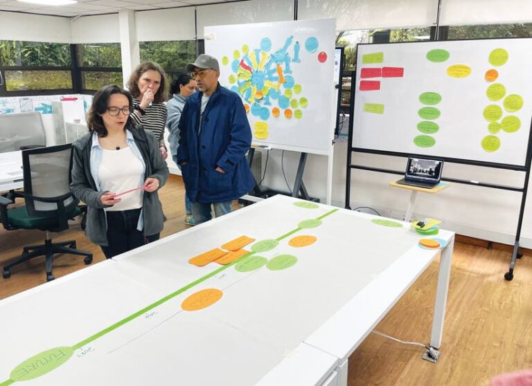
GIS practitioners and GIScientists are naturally positioned to lead and contribute to these collaborative efforts through the geographic approach by facilitating codesign through participatory GIS. Dr. Amy Frazier’s team, for example, is working with partners at the Alexander von Humboldt Biological Resources Research Institute in Colombia—an independent entity of the Colombian government that conducts scientific research on biodiversity—to codesign maps and scenarios of future land-use needs. By including many different voices, actors, and agencies throughout Colombia in the mapping process, the team aims to build collaborative land-use scenarios that balance future needs for increased food production and clean energy expansion with the preservation of key plant and animal species.
Integrating Science with Decision-Making
Community-embedded research connects science to practice, and GIScientists—who are often trained in geography—are uniquely positioned to be the connective tissue that integrates science and decision-making.

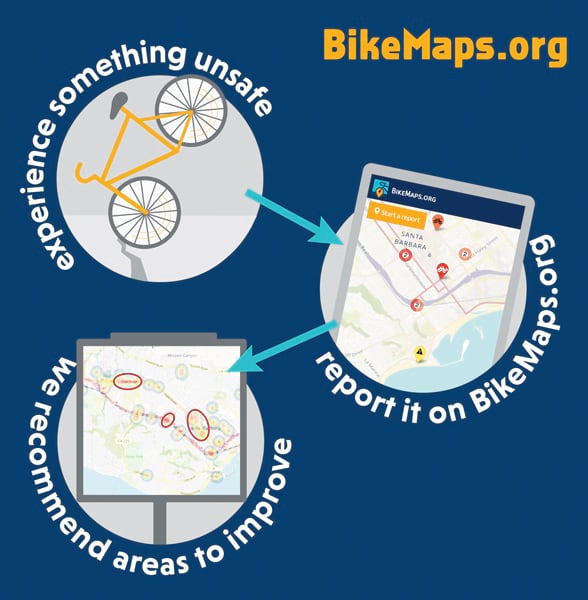
An example is the participatory GIS initiative BikeMaps.org, which maps bicycle collisions, near misses, and hazards around the world. Founded by Dr. Trisalyn Nelson, the Bikemaps.org platform not only offers a user-friendly map but also pairs GIS technology with outreach and engagement resources that support city-level decision-making.
For more than a decade, Nelson’s team has been using BikeMaps.org to assist transportation planners in deciding where, when, and how to invest in infrastructure that makes bicycling safer and more accessible for all people. The team is using the BikeMaps.org mapping platform as a tool for community engagement and, through the map, is generating important conversations among community members, decision-makers, industry leaders, advocates, and policymakers.
Given that GIS professionals are often invited to provide information for decision-making, BikeMaps.org is a good example of how GIS and mapping can be used to convene conversations, generate knowledge, and build consensus around public policy.
How to Amplify the Impact of Your Work
GIS professionals all leverage maps to better understand the world around them. So think about who is being included and supported in these efforts.
Who is involved and who is excluded in the creation of GIS questions and answers? And how can you pair your GIS work with codesign and community engagement to amplify the impact of your work?
There has never been a more exciting time to be a GIScientist. It will be exciting to see where all this leads!
For more information, reach out to Frazier at afrazier@ucsb.edu or Nelson at trisalyn@ucsb.edu.


