Esri partners can help customers implement GIS for a range of needs, from streamlining operations and asset management, to monitoring and being proactive about network management. Take a look at how Esri partners Clearion, Schneider Electric, ITpipes, and Eos Positioning Systems assisted utilities and cities in making the most of their GIS implementations and improving performance.
Routing Tree Cuttings Toward Eco-Friendly Causes
For most utilities, it is a continual challenge to keep vegetation away from power lines and manage the resultant debris. In Georgia—which has heavy tree coverage even in the metropolitan capital of Atlanta—this challenge became an opportunity for the state’s largest utility to help feed local zoo animals and support nearby farmers.
-

At Zoo Atlanta, elephants, giraffes, and other browsing species eat tree cuttings from Georgia Power as part of their diet.
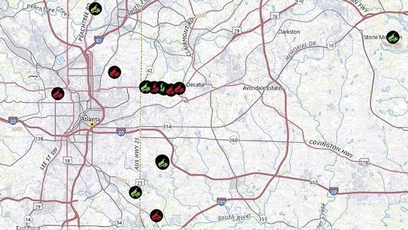
Georgia Power, an investor-owned electric utility that provides reliable service to more than 2.7 million customers, partnered with Clearion to find eco-friendly ways to manage freshly cut vegetation and wood chips. Clearion developed two specialized workflows that enable Georgia Power’s tree pruning contractors to pinpoint where trimmed branches from certain tree species are located so they can be routed to two partners. The first, Zoo Atlanta—a leader in conservation and one of the oldest continuously operating zoological institutions in the United States—takes the tree branches, known as “browse,” for elephants, zebras, giraffes, and other browsing species to enjoy as part of their diet. The second, the Grassroots Growers Alliance (GGA), takes the tree cuttings and distributes them as wood chips to local Atlanta farms.
To allocate these resources efficiently, Georgia Power tapped into Clearion’s vegetation management platform, which is built on ArcGIS Maps SDK for JavaScript and ArcGIS Maps SDKs for Native Apps. By leveraging this platform along with ArcGIS Field Maps and ArcGIS Dashboards, the utility found innovative ways to repurpose tree branch cuttings that would otherwise go to waste.
Horticulturists at Zoo Atlanta use Field Maps to navigate to places where tree trimmings are available for collection, and within minutes they have a hefty supply of browse for hungry zoo animals. The GGA employs Field Maps to update the status of its wood chip delivery points to ensure that farmers receive the wood chips they need. Both partners, along with Georgia Power, use the dashboards to get a high-level look at the locations of available tree trimmings and, in the GGA’s case, the status of wood chip drop-off sites.
As a result of this initiative, Georgia Power has significantly reduced disposal costs by avoiding unnecessary travel to distant dumping locations. Contractors can now rely on Clearion’s platform to locate tree trimmings and wood chip delivery points, lowering fuel expenses and mitigating their environmental impact. Zoo animals benefit from locally sourced, nutrient-rich browse that enriches their diets, while zookeepers and horticulturists have a simplified workload thanks to a reliable, streamlined process. Additionally, local farmers that feed 130 families on a biweekly basis receive a steady supply of wood chips that enhance soil quality and crop yields for the entire community.
Georgia Power’s motto is to be “A Citizen Wherever We Serve.” This effort spotlights the utility’s strong commitment to sustainability and support of environmentally focused nonprofits. And its collaboration with Clearion stands as a model for creative resource management, demonstrating how technology-driven solutions can benefit business operations, local communities, and the environment.
Bringing Network Management Up to Date
Connexus Energy, Minnesota’s largest customer-owned electric cooperative, serves more than 145,000 customers with reliable and sustainable electricity. Known for its innovative energy solutions, including solar and battery storage, Connexus prioritizes community service and environmentally friendly practices.

In 2019, leaders at Connexus decided that the company needed to modernize how it manages its network. They wanted to introduce an integrated outage management system and a supervisory control and data acquisition system to streamline operations and improve reliability. Leadership recognized the importance of having a modern network management system to advance the company’s distribution goals and aimed to upgrade the design-build workflow to incorporate real-time data.
Connexus previously used ArcFM Classic from Schneider Electric for outage management and GIS editing. For this transition, Connexus implemented Esri’s ArcGIS Utility Network for a unified model to manage its connected network, Schneider’s ArcFM Solution XI Series to streamline design and construction workflows, and Schneider’s EcoStruxure ADMS to get real-time forecasts and historical views of the distribution network. This new system supported the company’s immediate design-build and GIS needs, reducing design backlogs and enhancing productivity.
The project, which began in late 2019, was phased, with Connexus issuing a request for proposals to integrate various systems. The GIS team played a crucial role in data migration, ensuring minimal duplication and seamless operations. By early 2023, Connexus had a robust data model and had finalized its software vendor selection. Utility Network went live in mid-December 2024, with the ADMS set to go live in early 2025.
Connexus has already experienced benefits from the new system, including improved data management and optimized processes. The Utility Network data model enhances data quality and simplifies management, aligning closely with systems such as the ADMS. Business and validation rules ensure data accuracy, and the company has seen performance improvements. The project has also optimized processes by reducing overhead and cutting down on unnecessary data capture.
The new digital environment at Connexus supports efficient workflows. Having tools that are designed for specific roles enhances training and operations. Moreover, the system incorporates ArcFM Feeder Services, which provides an out-of-the-box bidirectional integration between ADMS and ArcFM Solution XI Series, ensuring an up-to-date operational network. This simplifies processes and troubleshooting.
Video- and GIS-Based Inspections Enable Proactive Asset Maintenance
The City of Tuscaloosa, Alabama, faced significant challenges managing its extensive sewer infrastructure, which includes 507 miles of sanitary sewer lines and 252 miles of storm drains. Frequent sewer overflows, environmental hazards, and costly emergency repairs highlighted the need for the city to take a more proactive and efficient approach to maintenance.

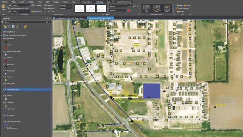
So the city partnered with ITpipes and Esri to integrate video inspection technology with advanced GIS. ITpipes’s inspection software seamlessly connects with ArcGIS Pro 3.2 and an asset management system from another Esri partner, CentralSquare Technologies (formerly Lucity). This enables teams across the city to engage in comprehensive data sharing. Mobile crews and office workers, for example, can access asset data in real time, meaning they can prioritize maintenance based on accurate pipeline condition assessments.
The city deployed ITpipes Mobile, allowing city staff to conduct pipe inspections using closed-circuit television (CCTV) feeds. Since ITpipes Mobile integrates with ArcGIS Pro, crews receive cached, location-based visualizations and detailed information about each asset. Using mobile inspection PCs, crews can view GIS-based maps preloaded with pipeline attribute data, select assets for inspection, and record findings in the system.
Each night, inspection data and videos that are collected in the field using ITpipes Mobile are automatically synced with ITpipes Web. This process updates ITpipes Web and ArcGIS Pro with newly gathered inspection data while simultaneously downloading fresh work orders to ITpipes Mobile. This ensures that mobile crews have the most up-to-date assignments the following day.
Within three years of implementing this solution, the City of Tuscaloosa achieved a 50 percent reduction in sewer overflows and significantly decreased emergency repairs. By inspecting and assessing more than 400,000 feet of its system annually, the city shifted from performing reactive maintenance to doing predictive maintenance, optimizing resource allocation and reducing downtime.
According to Tuscaloosa asset management quality control specialist Joy Cowart, the new system has strengthened operational efficiency and supports data-driven decision-making, contributing to a cleaner, safer community.
“ITpipes [provides] a very versatile tool that helps efficiency in all processes through the City of Tuscaloosa, including [not only] repairs and maintenance of sewer assets but also billing and capital improvement projects,” Cowart said. “Its seamless integration with Esri’s GIS platform enhances data accessibility and decision-making. It is very user-friendly, and the tech support team is amazing!”
Through this partnership, the City of Tuscaloosa has shown how cutting-edge technology can elevate sustainability in municipal infrastructure management.
Accurate GIS Data Is Key for a Growing City
The City of Seguin serves over 30,000 residents with water, wastewater, and electric utilities. The Utility Services Department, led by smart grid solutions manager John Saldana, supports internal utility infrastructure teams with an enterprise GIS.
-
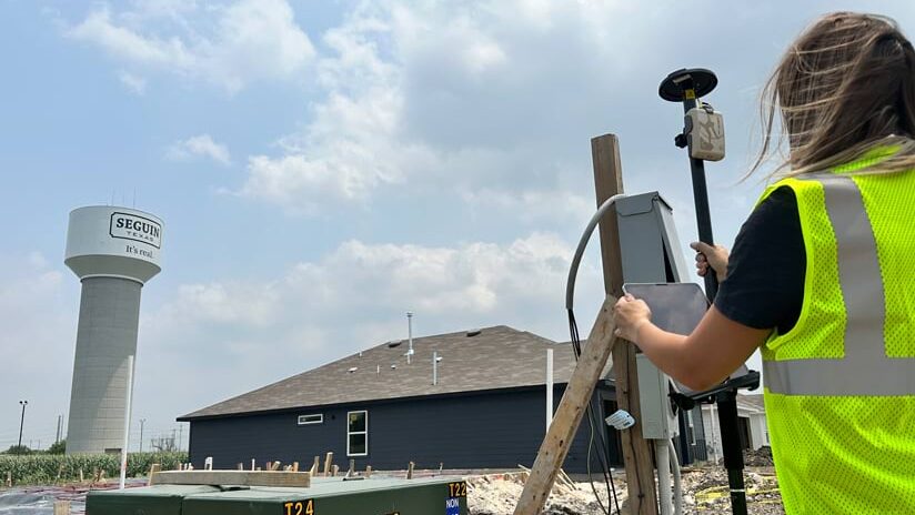
The City of Seguin is mapping utility assets as new neighborhoods get developed.
“We are the middleman between utilities and the city,” said Saldana.
Rapid expansion in Seguin has increased demand for utilities. As surrounding farmland gets developed, staff at the city wanted to accurately map existing assets prior to construction to help builders avoid accidents. They also wanted to map new infrastructure to streamline future asset management.
To begin this project, Saldana equipped mobile crews with ArcGIS Field Maps and Arrow Gold GNSS receivers from Eos Positioning Systems. The Arrow Gold receiver connects to an Arrow Gold base station, helping the city achieve centimeter-level location accuracy during data collection.
As crews gather information, Seguin data analyst Felicia Helms checks the quality before integrating the data into the city’s enterprise GIS. In doing so, Saldana and Helms have prepared the city for two big projects.
First, Seguin has leveraged smart-meter upgrades to help comply with the Environmental Protection Agency’s Lead and Copper Rule Improvements, which aim to get lead pipes replaced in communities across the United States over the next decade. As technicians upgrade meters, they capture photos and location data for each water meter pit. Saldana is now prototyping an AI model to analyze these photos to identify lead service lines.
Second, Seguin is migrating its electric utility data to ArcGIS Utility Network. Helms leads this effort, which will streamline management of the city’s electricity infrastructure and support its outage management system. A similar process will follow for the water utility network.
Having accurate GIS data is imperative for utility management, Saldana emphasized.
“Data does not exist in a silo,” he said. “It’s designed to be shared, expanded upon, integrated, and consumed upstream and downstream. We keep this in mind as we’re building and capturing something as simple as a point. This is where it all starts.”