Understanding the Need for Clean Water
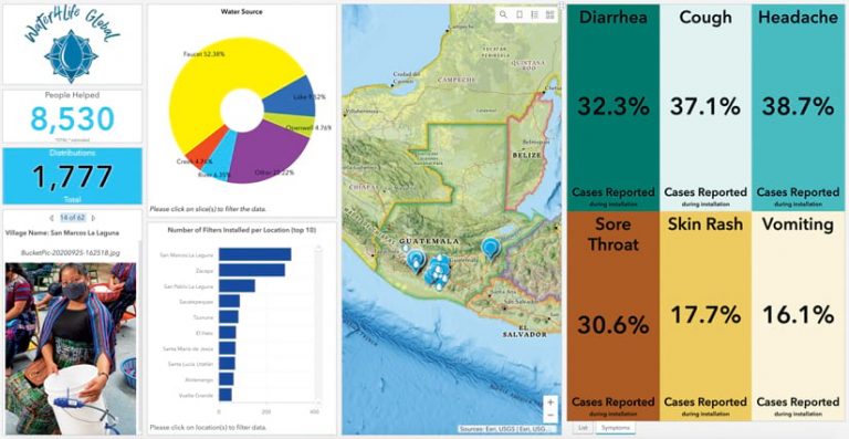
Water4Life Global (W4LG) is a nonprofit based in San Diego, California, that works in Guatemala distributing water filter technology products to villages in need. In Guatemala, it is estimated that 1 out of 20 children will die before they reach kindergarten, and this is mainly due to lack of safe drinking water.
To assist W4LG in its efforts, Bay Park Data Solutions, an Esri partner, developed a custom questionnaire using ArcGIS Survey123 that enabled W4LG to better understand the clean water access needs in each village and track relevant information about each family including a photo for follow-up and marketing purposes. The data collected in rural villages was then uploaded to ArcGIS Online so that US stakeholders could track the project in real time via an online dashboard. ArcGIS StoryMaps stories supported the team’s marketing and fund-raising efforts.

Using Esri’s platform and technologies Bay Park Data Solutions built GIS solutions for W4LG that provide visual information to make better, more informed decisions, improve transparency with donors and stakeholders, and empower W4LG to tell its story visually to increase fund-raising efforts. Water4Life Global has distributed nearly 2,000 water filters over the past two years and plans to distribute an additional 1,500 filters in 2021.
Bay Park Data Solutions understands how important monitoring, evaluating, and tracking outcomes is for a nonprofit. These measurements help a nonprofit’s donors and stakeholders understand its progress each year.
Cloud-Hosted Location Intelligence Accelerates Recovery
According to the National Oceanic and Atmospheric Administration, 2020 set a new annual record with 22 disaster events in the United States. Each event exceeded $1 billion in losses. Postdisaster, the Federal Emergency Management Agency (FEMA) deploys field staff to affected areas to assess damages and justify the flow of federal funding to aid recovery for survivors. FEMA’s mobile damage assessment and survivor interaction tools must be scalable, secure, and easy to use—and in some cases, available 24/7 for weeks at a time while data is collected.

FEMA partnered with Ardent Management Consulting (ArdentMC) to architect and maintain a secure and accredited ArcGIS Enterprise deployment in AWS GovCloud (US). ArdentMC is an Esri partner, holding the Esri Release Ready and Esri Cloud Services specialties. The company is also an AWS Advanced Consulting Partner and has AWS Public Safety and Disaster Response Competency. This unique combination of Esri cloud solution engineering competencies supports public safety and disaster response.
The secure ArcGIS Enterprise environment created by ArdentMC supports FEMA’s Disaster Survivor Assistance (DSA) and Preliminary Damage Assessment (PDA) missions through Esri mobile solutions. These field tools, when coupled with analytics solutions built using ArcGIS Dashboards, ensure the success of FEMA’s mission. Using this environment, FEMA was able to provide the following support in 2020:
- A total of 111,895 disaster survivor interaction surveys occurred.
- A total of 21,814 community interactions were completed, with 8,509 organizations willing to distribute information. This resulted in disaster-related information being potentially available to 8 million individuals.
- In eight states and Puerto Rico, 1,101 PDAs were completed.
Using secure, cloud-hosted tools built on ArcGIS Enterprise, FEMA can now more efficiently collect information on survivor needs, community services, and environmental hazards impacting communities postdisaster.
Digital Assessor Maps Improve Efficiency and Accuracy
In 2015, San Mateo County’s Office of the Assessor-County Clerk-Recorder and Elections (ACRE) created a strategic plan to foster a GIS environment focused on reducing redundant efforts, creating more accurate information, and increasing citizen engagement and transparency.
ACRE is the largest consolidated department in the State of California. It combines the constitutional office of the assessor with other constitutionally mandated functions of the clerk-recorder and elections to serve 770,000 residents in 20 cities and 70 jurisdictions. ACRE has a reputation for investing in GIS and technology to find ways to gain efficiency and reduce waste.

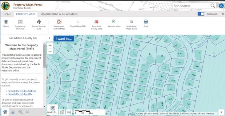
With that vision in mind, San Mateo County contacted Bruce Harris & Associates (BHA), a company specializing in GIS mapping and providing GIS solutions to local government agencies. In 2017, San Mateo County hired BHA to remap the county’s 230,000 parcels, replacing a 20-year-old legacy GIS. Working with the county, BHA consolidated multiple databases and redrew parcels from source materials to eliminate redundancies and greatly improve accuracy. Parcels were delivered in the ArcGIS Parcel Fabric data model on time and within budget.
ACRE can now digitally produce all assessor maps, eliminating the time-consuming hand-drawing process previously used and providing an immediate return on investment (ROI). With this foundation in place, ACRE is now completely aligned to take advantage of ArcGIS as well as the portal infrastructure put in place by the Information Systems Department (ISD).
The county has already used this technology to support response to recent fires and assist work-from-home efforts to ensure business continuity during the COVID-19 pandemic. The county’s strategic plan can now be accomplished using Esri’s applications for local government. ACRE’s investment in GIS and its trust in BHA resulted in a successful project that will continue providing benefits to the county for years to come.

