Imagine completing an ArcGIS project from start to finish without needing to click a user interface, open a tool, load a spreadsheet, or adjust symbols and colors. Rather than manually creating a map, users would simply communicate their requirements in natural language inside the software. A few prompts later, the user would have a map with their desired appearance and specifications.
These are real possibilities being investigated and evaluated by research and development teams building generative AI capabilities into ArcGIS. Early prototypes have shown promise in making this vision a reality.

In GIS, AI assistants offer a compelling opportunity to democratize what is already a powerful technology. They stand to make geospatial understanding more accessible to a wider audience and empower users of all skill levels to tackle complex challenges.
A different type of AI is already in use in ArcGIS.
Geospatial artificial intelligence, or GeoAI, accelerates GIS outcomes by leveraging AI subfields like pattern recognition, computer vision, and machine and deep learning methods. GIS professionals use it to automate feature extraction and similar repetitive tasks and to perform advanced analyses.
The development of AI assistants and GeoAI demands careful navigation, given the sensitive nature of GIS work and the important decisions that follow from it.
Esri is embracing the power of AI and the promise it brings. While it is tempting to move quickly, doing things right is more important than doing them fast.
GeoAI Transforms How GIS Work Is Done
With GeoAI, artificial intelligence is already delivering on its promise to dramatically improve how organizations solve spatial problems. It enables ArcGIS users to automate tasks that once required extensive manual efforts.
GeoAI tools are especially good at extracting meaningful geospatial features from a variety of data sources, including text documents and images. ArcGIS—with any of the 70-plus ready-to-use pretrained deep learning packages from Esri—can help users automate the extraction of features such as buildings, land-use polygons, swimming pools, solar panels, or trees from imagery or 3D point clouds.
Many different types of organizations use GeoAI capabilities to enhance their geographic approach.
A highway maintenance department can use GeoAI to identify cracks in roads based on drone imagery. Then staff can integrate this with data on traffic patterns to prioritize repair work.
Aid organizations can use GeoAI to make quick damage assessments. Using ArcGIS and a deep learning model, they can compare before-and-after satellite images and identify damaged buildings on a map.
In regions of the world where people live in informal settlements, local governments can use GeoAI to take a more accurate census. The process involves capturing aerial imagery and then, with a deep learning model, extracting building footprints to estimate population.

Each of these scenarios would have required tedious digitization that, in the past, was done manually. Now, users can apply out-of-the-box deep learning models to accelerate the job.
GeoAI also enables predictive analysis of vector data through machine learning algorithms. For example, a machine learning model can be used to estimate flash flood risk in an area based on factors related to precipitation, topography, hydrology, policies, and population demographics.
All this allows for better decision-making and planning by incorporating data-driven insight into GIS workflows.
The Importance of Trustworthy AI for GIS
As everyone knows, the GIS community does important work that informs impactful decisions. It is, therefore, imperative that the data involved is accurate and up-to-date.
This is a fundamental GIS concept that has been true for decades. AI raises the stakes—especially where decisions from AI models affect people and communities.
GeoAI in ArcGIS is built by following the highest standards for trustworthy AI, including well-documented models and instrumentation to help users measure accuracy and bias in analysis.
As has always been the case, GIS professionals must ask the right questions of the data.
Development of AI Assistants Shows Promise
Recent advancements in language models have opened exciting new possibilities for building generative AI capabilities into the ArcGIS user experience. These assistants are still in early development, but several prototypes have shown promising potential.
Broadly, two types of AI assistants are being evaluated inside ArcGIS.
The first type, embedded assistants, are designed to boost productivity on everyday tasks. They provide suggestions and automate repetitive actions inside regularly used ArcGIS tools.
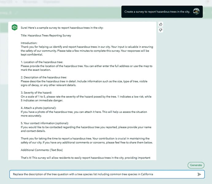
Furthest along in development is a beta feature in ArcGIS Survey123. This assistant simplifies the survey design process by providing a conversational approach to building surveys. Prompting the assistant just as they might with ChatGPT, users can quickly create a survey draft without needing to navigate menus or interfaces in the tool.
Other embedded AI assistants are in the early stages of research and development at Esri.
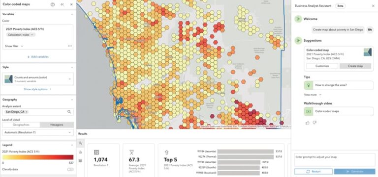
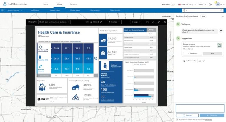
One of these AI assistants aims to help ArcGIS users author SQL, Python, Cypher, and Arcade expressions in ArcGIS Pro. Another is the ArcGIS help system chatbot trained on volumes of ArcGIS documentation that can quickly answer how-to questions. A third assistant would help users conduct market planning and site selection inside ArcGIS Business Analyst.

Apart from the embedded assistants, the second type of assistant being evaluated for use in ArcGIS technology is a broader general AI assistant that might someday encompass the entire ArcGIS experience. Think of this as a sophisticated chatbot that understands GIS data and tools and can answer geospatial questions.
As a simple example, a municipality using ArcGIS Hub could build a site with a public-facing AI assistant that interprets a query about trash pickups. The assistant would reference authoritative open data about the pickup schedule from within the public works department’s hub site and use a geocoding service to discern the user’s location.
Accuracy is paramount in the design. This assistant would invite the user to confirm their location by creating a map showing the geocoded address. For transparency, the assistant would cite its source—a public works database.
Progressing with Deliberate Caution
The development of AI technology is moving at an astounding pace. We have only scratched the surface of what AI can do in GIS.
Users are already doing the foundational work. They are publishing data as services and adding metadata. High-quality data forms the backbone of how AI systems learn and reason.
In developing the AI tools for ArcGIS, much of the work involves mitigating risks. This means constraining inputs to authoritative sources and building configurable guardrails.
The development process demands responsible implementation. An Esri AI advisory board—a cross-functional team of technology, product, legal, security, and privacy officers—provides guidelines for responsibly implementing AI in ArcGIS.
Through a commitment to responsible implementation and continuous learning, Esri is helping organizations apply the promise of geography and AI to solve the most challenging problems.

