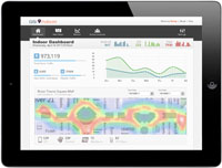
Redlands, California—Esri announced that it has joined the worldwide In-Location Alliance. Esri joins a growing number of companies that have come together to drive innovation and market adoption of high-accuracy indoor positioning and related services. Esri will help to define standards for indoor mapping and logistics across many industries including health care, higher education, finance, government, and retail.
“This is an exciting, new frontier for GIS and location analytics, and we are able to help the global community indoor logistics with standardized, high-accuracy mapping and analysis tools,” said Wolfgang Hall, Esri’s industry manager for logistics and supply chain management.
The Alliance began in August 2012, and provides a forum for collaboration for members to share their experiences, provide solutions based on a common architecture, and work together towards common interests.
Esri and its partners have provided technology for indoor mapping for many years, predominantly in facility mapping. The Esri ArcGIS platform of desktop, server, mobile, and cloud software and services gives users the ability to do the following:
- Move from existing architecture drawings to navigable indoor maps
- Create a common operating picture for indoor asset tracking using the facility management data model
- Manage data for both private and public use for safety and security
To learn more about Esri’s initiative for indoor logistics, visit esri.com/indoors.

