We are pleased to announce the February 2025 update of ArcGIS Survey123, with valuable enhancements and fixes designed to enhance your data collection experience. This incremental release brings improvements to the Survey123 field app, Survey123 Connect, and the Survey123 web app. We are committed to empowering you with a comprehensive suite of tools for seamless form-based data collection in the field and on the web.
- Survey123 Connect: Create hosted feature layer views for submissions
- Updates to GNSS device support in the Survey123 field app
- Updates to the Survey123 web designer
– Map tools
– Z-values
– Large attachments - Other enhancements and bug fixes
(note: The updated Survey123 mobile app will be available soon on the Google Play Store, alternatively Android users can download the latest version as an APK from the Survey123 website)
Survey123 Connect: Create hosted feature layer views for submissions
We are excited to introduce a new feature in Survey123 Connect that enhances your data management capabilities: the ability to create hosted feature layer views for submissions.
Feature layer views in ArcGIS Online allow you to visualize and analyze your hosted feature layer data in various ways without modifying the underlying dataset. These views serve as customizable lenses, enabling you to give others unique and customized access to feature layer data.
Hosted features layer views can improve data security. When working with sensitive information, it is crucial to protect your survey’s source feature layer. By keeping your survey feature layer private and creating feature layer views, you can maintain better control over sharing and privilege settings, ensuring the security and integrity of your data.
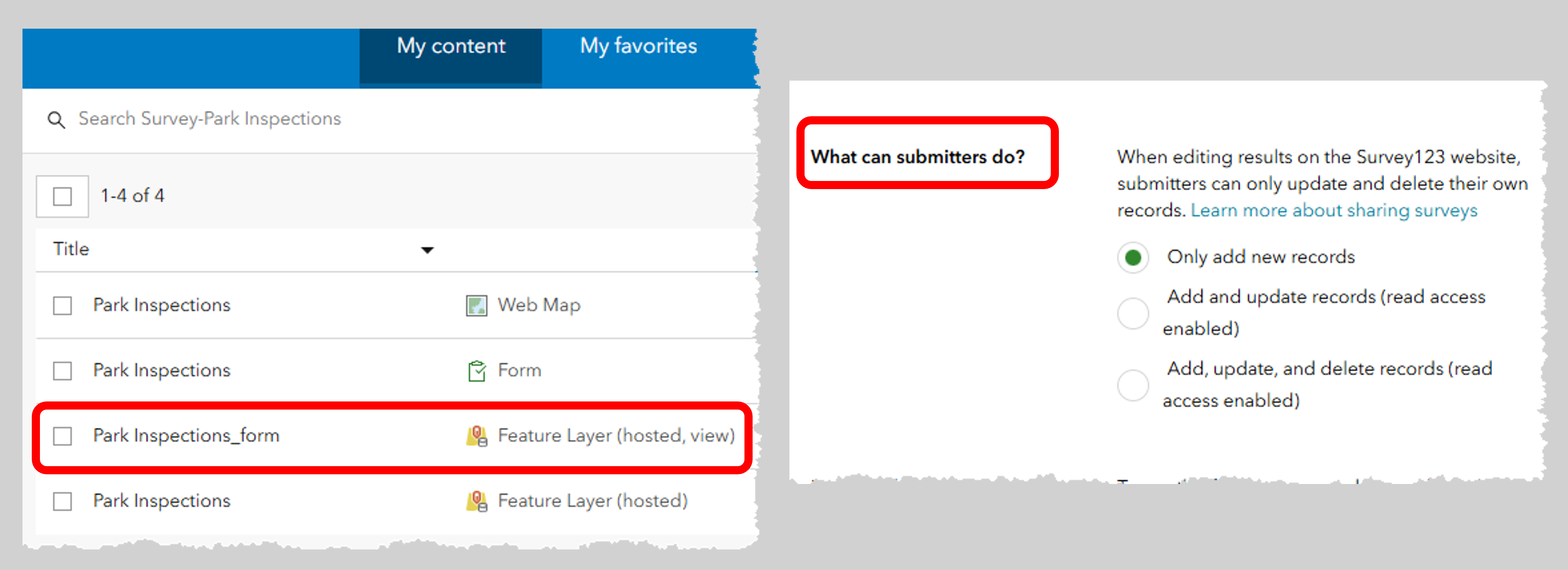
In this release of Survey123 Connect, a new submission feature layer view is now automatically generated the first time you publish your form. This hosted feature layer view, named “SurveyName_form”, manages editing access to the survey’s feature layer. You can then control specific submitter access through the “What can submitters do” option in the share results section of the Survey123 web page.
Note: This new feature in Survey123 Connect complements the existing capability of creating hosted feature layer views when publishing surveys using the Survey123 web designer

Updates to GNSS device support in the Survey123 field app
A key feature of the Survey123 mobile field app is its support for external GNSS receivers, enabling high-accuracy location data integration into data collection workflows. This release of Survey123 includes updates to expand the range of GNSS units supported by the app.
The Emlid Reach RX is a compact and lightweight GNSS receiver designed for high-precision surveying and GIS data collection. Survey123 now supports connections to the Emlid Reach RX (Android) and Emlid Reach RX MFi (iOS, Android) external GNSS receivers.
Additionally, we have enhanced support for connecting to Leica GNSS receivers operating on Android 12 and later versions.
Updates to the Survey123 web designer
Map tools
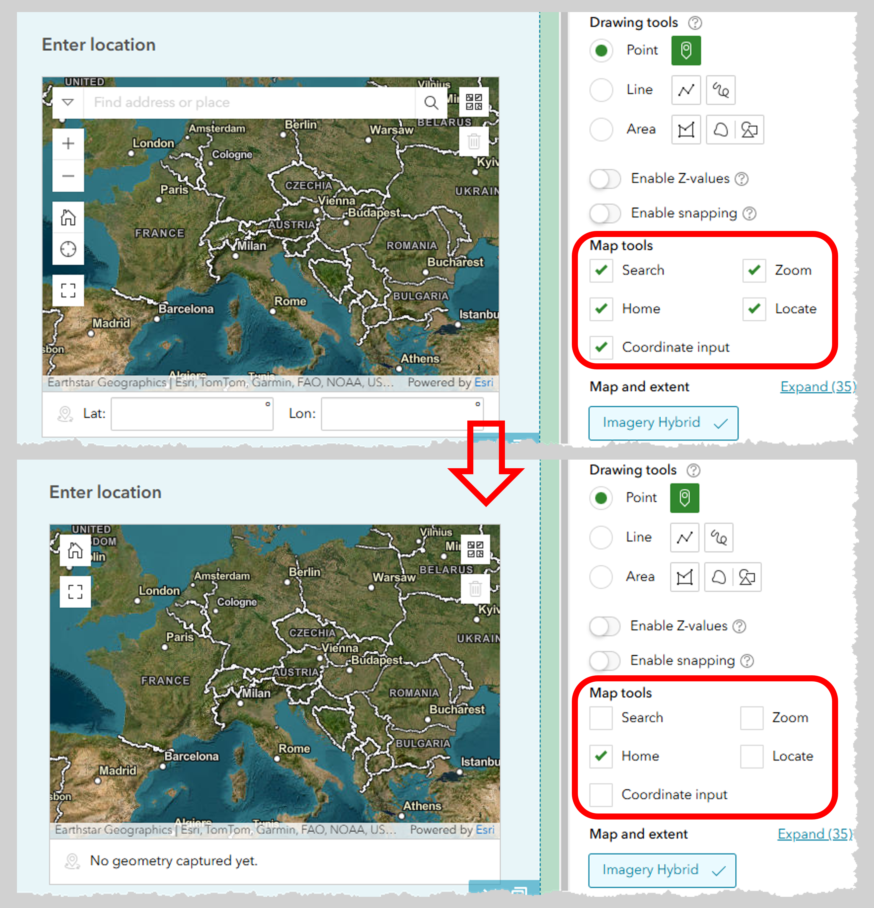
When designing a form using the Survey123 web designer, you have the option to utilize a map, address, or location list question to capture location data. You can now customize which tools are available in the map question, allowing you to provide a focused and streamlined experience based on specific data capture requirements. The individual map tools that can be enabled or disabled include the Search, Home, Coordinate input, Zoom, and Locate tools.

Z-value support
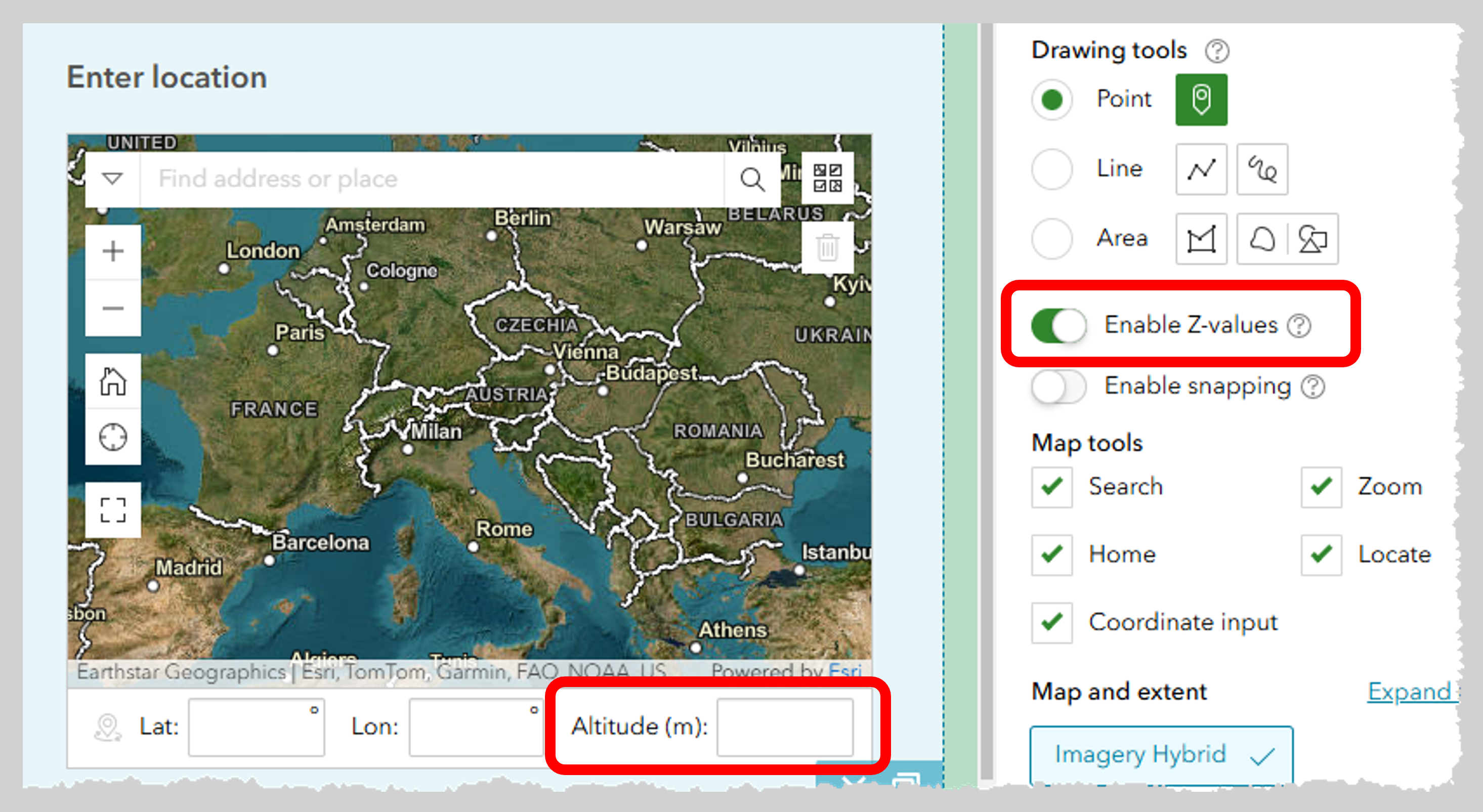
Z-values enable the display and analysis of GIS data in three dimensions. While standard feature layers utilize x and y coordinates to define locations on a two-dimensional plane, z-values add an additional dimension by representing height above or below a surface. The Survey123 web designer now includes an option to create Z-value enabled feature layers when authoring map (point) questions. Once z-values are enabled for a published feature layer, individuals submitting data can include the z (altitude) value for a collected point location.

Large attachments
Attaching media (images, audio, video) and files (doc, pdf) to surveys is a common practice for many users. For surveys in ArcGIS Enterprise 11.3 and above, the maximum file size for image questions has now been increased to 100MB, and the maximum file size for file questions has been increased to 500MB.
Other enhancements and bug fixes
- Field App
- BUG-000171796 A bug was fixed in which attachments with very large ID numbers would not display in a form that was opened from the Inbox.
- Connect
- BUG-000155440 A bug was fixed in which a survey connected to a feature layer view could not be updated.
- Website
- Support rendering content in Markdown format in Survey123 assistant
- BUG-000172800 Survey fails to publish or preview when question visibility rule refers to a value in a previous question containing unclosed quotes
- BUG-000173405 Some questions used in a calculation in the ArcGIS Survey123 web designer will not appear in the preview on the Edit panel even though the calculation executes as expected
- BUG-000172563 When there are three or more images in a notes section in Survey 123, the images disappear.
- BUG-000171268 ArcGIS Survey123 questions with custom-defined bind::esri:fieldLength return a back-end-code or non-human-friendly error when editing sent responses in the ArcGIS Survey123 web designer.
- BUG-000172930 Users with non-administrator roles are not able to access shared surveys from the My Favorites tab in the ArcGIS Survey123 website. ([My surveys] “My favorites” survey misses icons if the survey is shared to a non-owner/admin user)
- BUG-000172859 When viewing the response of a map question in the Data tab of Survey123, the question does not respect a configured zoom extent applied in the survey’s Design settings
- BUG-000172995 The results view layer for a survey published from the ArcGIS Survey123 web designer contains duplicate sublayers
- Web app
- Improved performance for multilingual surveys that contain dozens of languages
- Support
mapTools=in thebody::esri:stylecolumn for geopoint, geotrace, and geoshape questions. - BUG-000171336 ArcGIS Survey123 Connect allows publishing a survey with an incorrect HEX code, returning the error “The survey is not accessible or does not exist” when attempting to access the survey form.
- BUG-000166224 An Arabic survey doesn’t align to the right in Survey123 web app when the first label or the customized survey description (the hint of generated_note_form_title) is not in Arabic.
- BUG-000172041 Pulldata(“@layer”) queries work intermittently when using a survey in the Survey123 web app (browser). (Issue with multiple pulldata JS, multiple async function cannot assure the correct answer is returned)
- BUG-000172998 Basemap gallery does not have scroll bar when launched in a map question when viewed in large map mode in the ArcGIS Survey123 web form
- BUG-000172666 Submitting an ArcGIS Survey123 response containing a repeat with a minimal appearance creates an empty repeat record for that submission
- BUG-000169683 The multiline appearance is not available in the ArcGIS Survey123 web form for an image question with a count-selected constraint
- BUG-000172671 The ArcGIS Survey123 web browser does not recognise photos with special characters in the filename uploaded for the image question
- Report
- Support new syntax
attachmentsDefExpin report template to filter attachments (equivalent to attachmentsDefinitionExpression) - BUG-000171173 Generating reports in ArcGIS Survey123 fails and returns an error message when the form_id string contains non-ASCII characters
- BUG-000166816 Generating a report for a ArcGIS Survey123 survey containing an unanswered geoshape question returns the error “An error occurred when rendering by report engine.”
- ENH-000165299 Request to add capability to generate a report for ArcGIS Survey 123 forms that identifies unanswered geoshape questions
- BUG-000172075 Survey123 reports fail to generate when a related table has an empty outStatistics parameter
- Support new syntax
Please stay tuned to our Survey123 Early Adopter Community and release blogs for more updates.
Join Us at the 2025 Esri Developer and Technology Summit! The Survey123 team will be present at the 2025 Esri Developer and Technology Summit, taking place from March 11-14 in Palm Springs. This is a fantastic opportunity for you to connect with our team, ask questions, and gain insights. We will also host a variety of technical sessions focused on advanced Survey123 topics, explore the latest updates, and share what’s on the horizon for the platform. We look forward to seeing you there!
- ArcGIS Field Apps Integration and Automation
- ArcGIS Field Apps: Best Practices for Field Workflows
- ArcGIS Field Apps: The Road Ahead
- ArcGIS Field Apps: An Introduction and What’s New
- ArcGIS Survey123: Getting Started with the Survey123 JavaScript API
- Automating End to End Workflows with Webhooks and ArcGIS
- Advanced Survey123 Form Expressions
Article Discussion: